Partner Profiles | Dymaxion Labs delivers geospatial analytics insights out of the most complex planet-scale imagery scenarios. We sat down with Co-Founder and CEO, Federico Bayle to learn more.
Hi Federico, we’re very impressed by your work over at Dymaxion Labs. Can you let us know a little bit about the history of the company?
Hi Nathan! I met my Co-Founder, Damian working in a real estate startup in Buenos Aires. Then, I began working on my Master’s thesis on informal settlement detection with satellite imagery and machine learning. After reading about space tech and the future of this market, I discussed the possibility of Damian joining me and starting Dymaxion to create tools to make geospatial analysis easy for data scientists.
We’re intrigued, where does the name, Dymaxion Labs, come from?
We are GIS nerds, and it shows in our name. The term Dymaxion comes from the Dymaxion map, which is an interesting map projection that allows you to project the Earth onto the surface of an icosahedron and unfold it in many different ways.
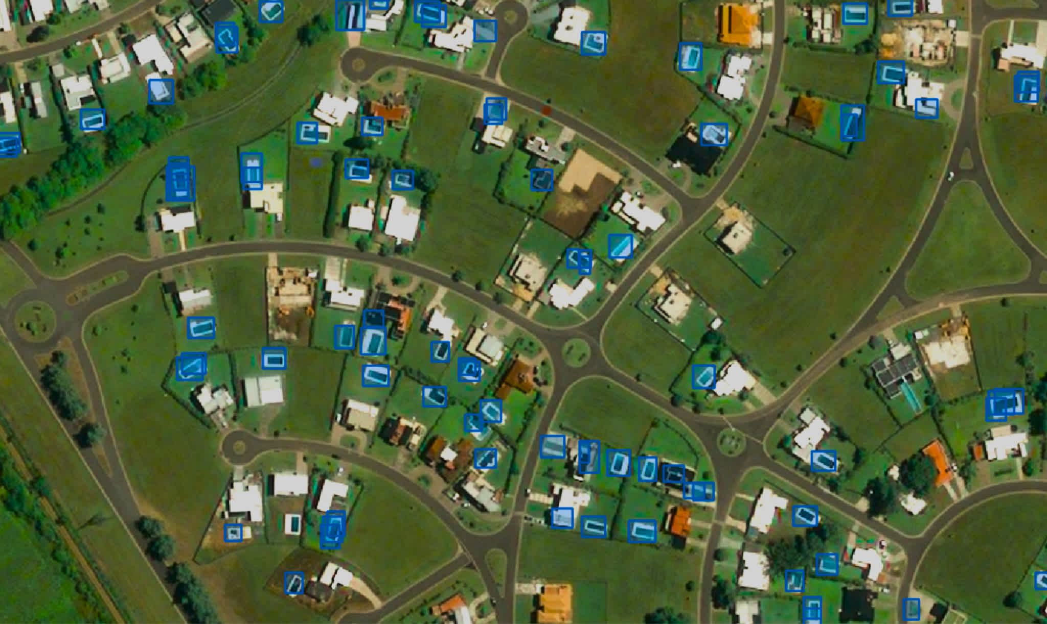
Dymaxion Labs have made their swimming pool detection algorithms available to UP42 customers. But you also offer agriculture, deforestation, and mining solutions. What is the common thread between these solutions? How does Dymaxion decide what algorithms and solutions to develop?
Great question. At the very beginning of the company, we figured out that 80% of the steps for creating solutions for each vertical have the same backbone. After working hard scaling them, we released it as an API to concentrate our effort in understanding, in depth, the last mile of each vertical. The first step in the roadmap is releasing our tools for optical data.
Your solutions leverage a wide range of data sources, from climate data to satellite-SAR-aerial-drone imagery. What are the challenges when working with such diverse data sources?
I think the most important challenge is understanding the acquisition process for each data set. When you understand the difference between passive and active sensors or between a weather station and an estimation with satellite imagery, then it’s easy to gather them in the same database. Even though our API is focused currently on optical data, we help our clients to integrate these different sources to add more value.
Dymaxion Labs has a mission to further urban development and contribute to solving the global challenges of climate change and food insecurity. Could you outline some of the challenges in these areas?
We think that urban development, climate change, and food security are problems that need to be addressed with a comprehensive point of view. As we mentioned in a blog post, we realized that our approach to mapping informal settlements was not enough to understand the complexity of the temporal evolution and dynamics of these areas. Analyzing each image at each date separately, without taking into account the environment in which the informal settlements are located, did not allow us to understand their dynamics in depth. In particular, we observed that the fragility in the macroeconomics of these countries associated with the agricultural sector and the exposure to climate change make a huge impact on the development of these areas.
How is Dymaxion Labs and, on a wider level, the geospatial community able to move the needle in solving these complex challenges?
At the same time that the upstream market continues to evolve and take more frequent and cheaper shots of our planet, the geospatial community will need to grow and incorporate developers, designers and social scientists to the teams. I’m very excited about the rise of new startups working on different steps of the chain value, from simplifying the data acquisition process to creating custom solutions for different verticals. We are filling the gap between training and deploying machine learning models in massive areas.
Solving these challenges requires global effort from mission-driven companies and NGOs. How do you balance the social mission of Dymaxion Labs with its commercial success?
We believe that it’s a decisive moment for our planet and we must make the necessary changes to make sustainable life on Earth for future generations. It’s common to hear those kinds of claims these days but I think that if we can help agriculture companies to produce more food more efficiently, insurance companies to evaluate the impact of a hurricane, and NGOs and governments to get up-to-date data of informal settlements location, we can have a concrete impact. Our strategy to accomplish that is giving the data science community tools to face these problems with Earth Observation data.
Could you tell us about your algorithm now available on UP42? And what the swimming pool detection block means for UP42’s users?
We are excited to start sharing our algorithms with UP42 and their community. Swimming pools’ location can be used not only for realtors but as a proxy for land value and urban development. The synergy between companies in the geospatial space can have a bigger effect compared to working each one separately.
Dymaxion Labs has a strong focus in South America—specifically with the block on UP42 able to study the region in detail. South America has a very active geospatial community. What are your thoughts on the current state of the market there and what opportunities exist for further development?
I think South America is a vast region with different kinds of natural resources. This creates a lot of opportunities to create technology for agriculture, mining and oil, and gas. Here we have a big entrepreneurial spirit that allows us to tackle problems that are not present in other regions. Part of the challenge that we are facing to live on a more sustainable planet is strongly associated with places located in our region, like the Amazonas in Brazil.
What are your plans for Dymaxion Labs in the next year?
This year we focused on releasing our API and started engaging with companies in the US and Europe. For the next year, we plan to close a seed round that will allow us to build a direct sales team there.
And, how do you see UP42 being a part of the future?
It’s a milestone for us to be part of the UP42 marketplace and we plan to upload more algorithms there. One of the most important steps that I think the geospatial community needs to do is explaining in simple words the value that our tools can add to a wide range of industries and UP42 is doing great in that regard.
Many of our readers are looking into the possibility of geospatial solutions. What would you say to people that haven’t yet discovered what geospatial data and analysis can do for them and their company goals?
I would say that I think in geospatial analytics as a way to incorporate up-to-date data with worldwide coverage. These days are highlighting the perks of being remote, not only regarding offices but also for data collection and monitoring. This market is just taking off.
What brings you the greatest satisfaction in your work?
My greatest satisfaction is working together with the amazing Dymaxion Labs team. The second greatest satisfaction is developing a product for which we are the first customer.
Any advice for aspiring entrepreneurs that want to start a company in the industry?
Think long term in an industry in which Earth is only the first step :)
Are there any geospatial books or magazines that you’d recommend?
There is a great community on Twitter. I love Joe Morrison’s geospatial market threads haha. Seriously, there is great content delivered in the Project Geospatial podcast. It’s a great point to start digging into our market. For a more technical perspective, The DownLinQ blog has amazing content.
What’s your favorite planetary perspective? (this can be anything from a specific satellite, processing algorithm, or geospatial insight that you’ve learned from geospatial analysis for clients).
Let me mention two perspectives. From the imagery side, I love the view of the Río de la Plata in the pictures taken from the ISS. Regarding algorithms, the Large Scale Mean Shift algorithm implemented in Orfeo Toolbox will be forever in my heart. It was my best friend during my thesis days and the Dymaxion’s beginning.
 Río de la Plata as seen from the ISS


