Use the UP42 data platform to grow your geospatial business

Introduction
Here at UP42, we’ve had the privilege to serve a wide range of geospatial customers, solving their problems and enabling their use cases. Along the way, we’ve learned a thing or two about the challenges that geospatial solution providers need to tackle along their growth journey. Finding the right archive imagery for your use case is often the first step in a long, complex process. How do you ensure the archive order doesn't exceed your budget? And how do you automate the purchase process to integrate imagery into your data pipeline?
The UP42 data platform is our singular solution – an API-first platform that provides access to the most advanced collection of archive satellite imagery from providers like Airbus, Capella Space, 21AT, and more. In this article, we’ll take a real-world approach to show how the UP42 data platform can help solve some major industry challenges.
The challenge
Imagine that a geospatial solution provider needs to build a change detection algorithm for a customer. The solution provider already has a technical team, with the required AI and machine learning expertise to build the model. What are some of the biggest bottlenecks they’ll face before they even begin to build the algorithm?

Let's assume that the solution provider needs an AI model that performs change detection over construction sites in Texas. They’re not looking for a single specific area of interest; instead, they need enough imagery over Texas to fit their particular technical and budget requirements. This collection of images will eventually be used to train the change detection algorithm and glean the required insights.
There’s already lots of conversation within our industry about the challenges of buying satellite imagery, so we won’t outline that here. In this scenario, our geospatial solution provider needs to place an order for thousands of high resolution satellite images with the following set of constraints:
- Imagery should be high resolution archive satellite imagery (less than 1m GSD) that covers Texas construction sites
- Cloud coverage should be low or negligible so that it doesn't interfere with analytics
- Programmatic API-based access should be possible so that images can be easily ingested into data pipelines
- Entire order should not exceed the initial budget estimations
Alright. We’ve established the business use case and the challenges. Now, the UP42 data platform comes in.
The UP42 data platform

You can sign up for free, enter your organization's relevant details, and dive right in. In this article, we’ll showcase how you can use the data platform API to find the imagery you need, estimate the price, and place an order for our business use case. We’ll use this documentation guide as a reference to set up the workflow and go through the various steps.
1. Discovery
The Data Discovery API shows you all available datasets on UP42. You can use the API to browse available data providers and specific data collections made available by a provider (Pleiades Neo, SPOT 6/7, TripleSat, etc.).
List Available Providers
The endpoint GET api.up42.com/hosts returns the following information about all data providers (or hosts) available on UP42.
List Available Collections
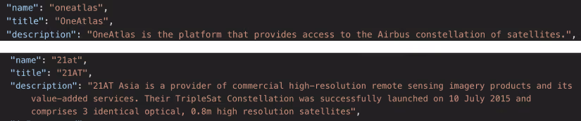
The individual datasets available from each provider are called a collection. Each collection represents a specific set of assets associated with the same sensor and technical specifications.
GET api.up42.com/collections returns the list of data collections, along with their generic information and metadata. This information helps us to make informed decisions about which dataset we’ll eventually order. In this use case, we’ll consider the following collections:
- TripleSat by 21AT
- Pleiades Neo by OneAtlas
- Pleiades by OneAtlas
- SPOT 6/7 by OneAtlas

2. Search
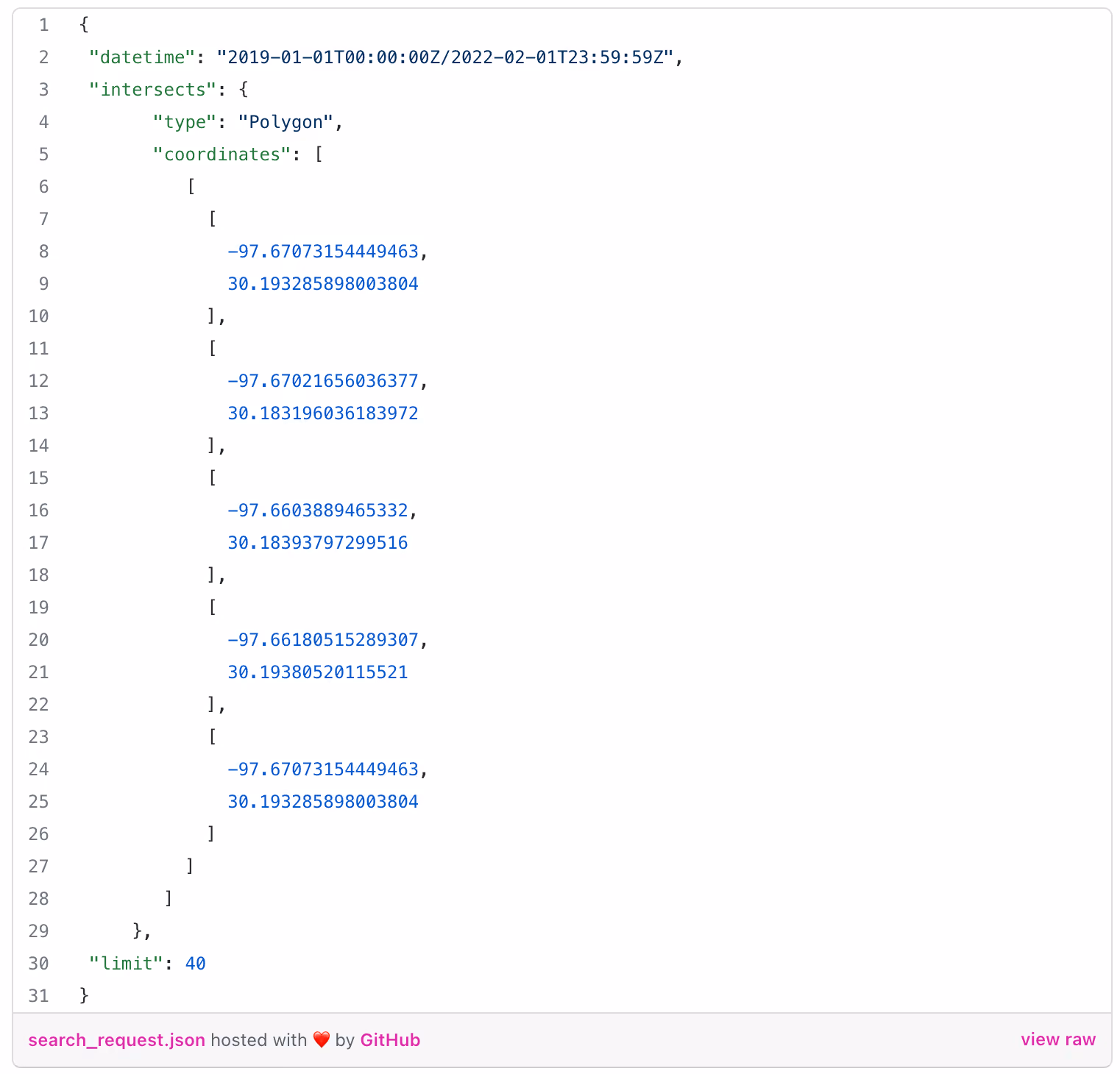
Now we have an idea of the available satellite providers and data collections at our disposal. We can already decide which collection to use based on factors like resolution and pricing. The Data Search API lets us search for all available imagery from a specific provider, and then further define search parameters until we find the exact type of archive imagery we need.
The endpoint POST api.up42.com/catalog/hosts/{hostName}/stac/search lets you query for all of the available images from a satellite data provider. The next step is to create a search request body that covers the coordinates, date range, and total number of images that we’re looking for.
3. Estimation and Ordering
At this point, we’ve identified the specific images that meet our requirements. The next step is to estimate the credit costs required for this order.
POST api.up42.com/workspaces/:workspace_id/orders/estimate returns the estimated number of credits you need to place the order. The cost estimation endpoint can be used to see how much the order costs. This way, we ensure that we fit the budget constraints. For this use case, we will place an order for TripleSat collection from 21AT with the following request body.
{

   "dataProduct":"37c26f4d-f6a9-47c9-ae4d-a095569ab8bc",

   "params":{

      "id":"TRIPLESAT_3_PMS_20220107163903_003B0CVI_012",

      "aoi":{

         "type":"Polygon",

         "coordinates":[

            [

               [

                  -102.88320004298258,

                  32.264981686710435

               ],

               [

                  -102.91136356544563,

                  32.257618640375384

               ],

               [

                  -102.9162790454608,

                  32.26345111457411

               ],

               [

                  -102.91749560562005,

                  32.27161334834995

               ],

               [

                  -102.84245733311445,

                  32.28952210079255

               ],

               [

                  -102.83907930528883,

                  32.28547466107444

               ],

               [

                  -102.8374890194068,

                  32.276612786110654

               ],

               [

                  -102.85633017913673,

                  32.27199225805447

               ],

               [

                  -102.86939841492453,

                  32.26763040450924

               ],

               [

                  -102.88320004298258,

                  32.264981686710435

               ]

            ]

         ]

      }

   }

}
4. Order Status Check and Download
Once the order is placed, the system will monitor the order status to see if it’s been completed (fulfilled). The following endpoint can be used to check the status:GET api.up42.com/workspaces/:workspace_id/orders/:order_id
Once fulfilled, the data will be delivered to storage on UP42. The asset ids information can be used to generate a download link:GET api.up42.com/workspaces/:workspace_id/assets/:asset_id/downloadUrl

Results
We just saw the end-to-end process involved in searching for the right kind of archive data for a use case, estimating the price, and then downloading the images to UP42 storage. When you’ve downloaded the images, you can use an open source tool like QGIS to visualize the output, and then use these images to start building your AI model for construction areas.
This is just one example of how the UP42 data platform adds value for geospatial solution providers. Watch this space for more data platform stories coming soon.

Subscribe to our newsletter
Stay up to date and learn about our fast-growing new features
