Wyvern and the power of hyperspectral imagery
Here at UP42, we recently added our first-ever hyperspectral partner: Wyvern. Which makes now the perfect time for an article that dives into all the amazing stuff hyperspectral imagery can do.
We’ve written about multispectral and hyperspectral before, but this time, we’ll focus solely on the hyper. First off, a definition, cause while we’d love it if you'd already read our first article, you may not have. We’re not judging you.
What does spectral mean?
When we say spectral, we're referring to part of the electromagnetic spectrum, which is separated into sections based on wavelength. Our eyes can see a small subset of the electromagnetic spectrum.
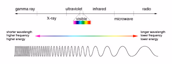
Radiation along the spectrum is classified by its wavelength. Gamma rays have wavelengths of less than 10 picometers (a picometer is one trillionth of a meter). The visible light portion of the spectrum ranges from around 380 to 750 nanometers (one billionth of a meter). And at the very end of the spectrum, the longest wavelengths, radio waves, can be anywhere from one millimeter to over a kilometer.
In remote sensing, the wavelengths that a sensor can capture are referred to as spectral bands. A sensor like Pléiades Neo, from Airbus, could be considered multispectral, as it captures 6 different bands, each of various widths:
Panchromatic: 450-800 nm
Deep Blue: 400-450 nm
Blue: 450-520 nm
Green: 530-590 nm
Red: 620-690 nm
Red Edge: 700-750 nm
Near-Infrared: 770-880 nm
Uniquely, the panchromatic band combines different wavelengths (blue, green, and red) to produce a higher resolution image, with the final output in greyscale. If you want to know more about the panchromatic band and how it can be given color, we have a whole article dedicated to that topic.
So that's spectral, in a nutshell. But how about hyperspectral?
Hyping up the spectrality of it all
Hyperspectral means even more spectral bands. There's no universally accepted definition of hyperspectral at the moment; different sources say different things. But you'll rarely find a sensor with more than 12-19 bands described as "multispectral."
While multispectral satellites usually capture bands in a range of 50 nm and upwards, hyperspectral satellites can get even more granular, going as low as 1 nm (though this isn't very common).
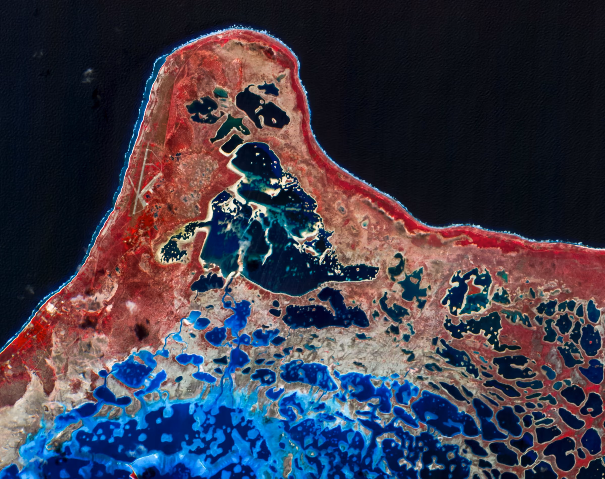
The true strength of hyperspectral imaging lies in its ability to distinguish spectral signatures with a much higher degree of accuracy than other imaging methods. Every material with its unique chemistry has its own unique spectral signature, which is how they emit, absorb, or reflect different types of radiation across the electromagnetic spectrum. For example, vegetation reflects green light and absorbs red and blue light.
With multispectral imagery, you can distinguish between different objects and types of terrain. Hyperspectral imagery provides more information and insight than multispectral imagery. With hyperspectral imagery, you can determine the surface chemistry and detect variations in surface materials that would be indistinguishable with multispectral sensors. An object's unique spectral signature and the added detail of hyperspectral imagery can unearth tons of insights. We'll get into more detail on this shortly.
But first, let's talk about hyperspectral in the context of our hyperspectral partner.
Wyvern: Finally, hyperspectral on UP42
Wyvern was founded in 2018 in Edmonton, Canada, where it's still based. Their Dragonette constellation currently consists of three hyperspectral satellites. Dragonette-001, which is fully operational, collects hyperspectral imagery in 5.3 m resolution. Data from Dragonette-002 and Dragonette-003 will be available later this year. Wyvern has plans to begin adding to its constellation with Dragonette-004, 005, and 006 starting in 2025.
Dragonette-001 boasts a resolution of 5.3 m, and 23 spectral bands ranging from 503 to 799 nm wavelengths on the electromagnetic spectrum.
Dragonette-002 and Dragonette-003, and eventually Dragonette-004, 005, and 006, all have a resolution of 5.3 m, and 32 spectral bands ranging from 445 to 880 nm wavelengths on the electromagnetic spectrum.
Wyvern's Dragonette constellation is first to market with high resolution hyperspectral satellite image data. It's well-suited for a variety of applications, including agriculture, energy, mining, forestry, and peace and security. With Dragonette-001, 002, and 003, customers can now receive frequent revisits of high resolution hyperspectral image data, a first for the Earth Observation market.
What are the practical applications of hyperspectral imagery?
As we've mentioned, hyperspectral data provides more has access to ever-more-granular levels of spectral detail, which makes it useful for various industries and missions
across the globe. Here are just three of its many potential use cases.
1. Environmental monitoring: Mining and energy
The ability to remotely monitor active or reclaimed mines or inactive wells from space with hyperspectral image data is critical to minimize the environmental impact from these sites. Hyperspectral imagery can easily capture large areas around mines for vegetation health and contamination analysis. It's great at detecting pollutants like heavy metals and acid drainage, and useful for monitoring sediment runoff, which needs to be carefully controlled.
Through spectral analysis, hyperspectral image data can reduce the need for on-site personnel, offering savings in cost and time.
2. Forestry: Wildfire prevention and planning
Dragonette imagery can improve and support planning, pre-positioning activities, and post-fire analysis and response. Through improved species identification and increased accuracy in forest fuel mapping, Dragonette hyperspectral image data has the potential to improve all parts of the fire-fighting cycle, starting with increased accuracy in fuel grid mapping. The added details from Dragonette hyperspectral bands are essential for species identification and health assessment of trees.
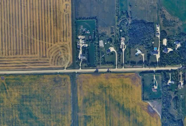
3. Crop classification
Every crop species has a unique spectral signature. With multispectral imagery, it's often hard or maybe even impossible to differentiate similar crops. Not so with hyperspectral.
Operational teams in the agricultural industry rely on crop classification and vegetative healthy analysis to predict yield, for future planning, and for market intelligence. It's hard to understate how important this data is: it's the key to making sure populations are well-fed and resources are used in the most efficient way possible..
Hyperspectral imagery is excellent at large-scale surveying of farmland. It can identify crops, monitor their health by pinpointing chlorophyll content/water stress/nutrient deficiency, and even detect pest or disease issues caused by changes in spectral signatures.
Wyvern on UP42
The above are just a few examples of what you can do with hyperspectral imagery. Curious about your use case? Reach out to us—our team would be happy to help. Or, head to the UP42 platform and start tasking Dragonette-1 now.


Subscribe to our newsletter
Stay up to date and learn about our fast-growing new features
