4 challenges with satellite tasking (and how to overcome them)

Satellite tasking means requesting a satellite to capture an image of your desired area. The ability for an individual to task a satellite is still pretty new; it wasn’t possible before the 2000s. And the ability to do so easily, without mountains of paperwork, is even newer.
Now, the race is on to see who can make it as easy as possible. And, as with any new technology or way of working, there are some bumps in the road.
Think about it this way: when you task a satellite, you’re commanding advanced technology floating thousands of kilometers above us to capture a vast chunk of the Earth’s surface. It’s pretty impressive. But there are lots of things that can impact the process.
To help your tasking order run smoothly, there are a few things that you should keep in mind. Here are four of the biggest challenges around tasking. And, of course, how the UP42 platform can help you solve them.
1. Not enough clarity around order requirements
Let’s say you want to task a certain satellite. You know what you need and when you need it. So you go to place your order, only to be met with a resounding “nope.”
The requirements for tasking, all too often, aren’t very clear. So the majority of customers won’t know about up-front limitations.
Most satellites will have a minimum Area of Interest (AOI), so if you try to place an order smaller than that area, it won’t go through.
Another thing to note is the complexity of your order. Are you looking for one simple square AOI, or do you have a bunch of different AOIs in elaborate shapes? Is one capture (also called mono) of your AOI enough, or do you need to capture it from different angles (stereo)? Also, if your AOI is larger than your chosen satellite’s swath width (the maximum area it can capture in one pass), you’ll need multiple passes to complete the order. And on top of all that, how much cloud cover is acceptable in your final images?
All of these factors contribute to the feasibility of your order. The time of year will also have an impact—for example, June through August is high season in the Northern hemisphere, so orders placed during this time usually take longer, and you might be facing competition for your desired sensor in busy areas.
How we’re solving this
When you create a tasking order on the UP42 platform, we try to make all the requirements clear right away.
If you’re using our console, you can either draw your AOI yourself, or upload an AOI file. We’ll instantly tell you if this AOI meets your chosen sensor’s requirements.
Our console also explains each parameter that you can configure, as shown below:
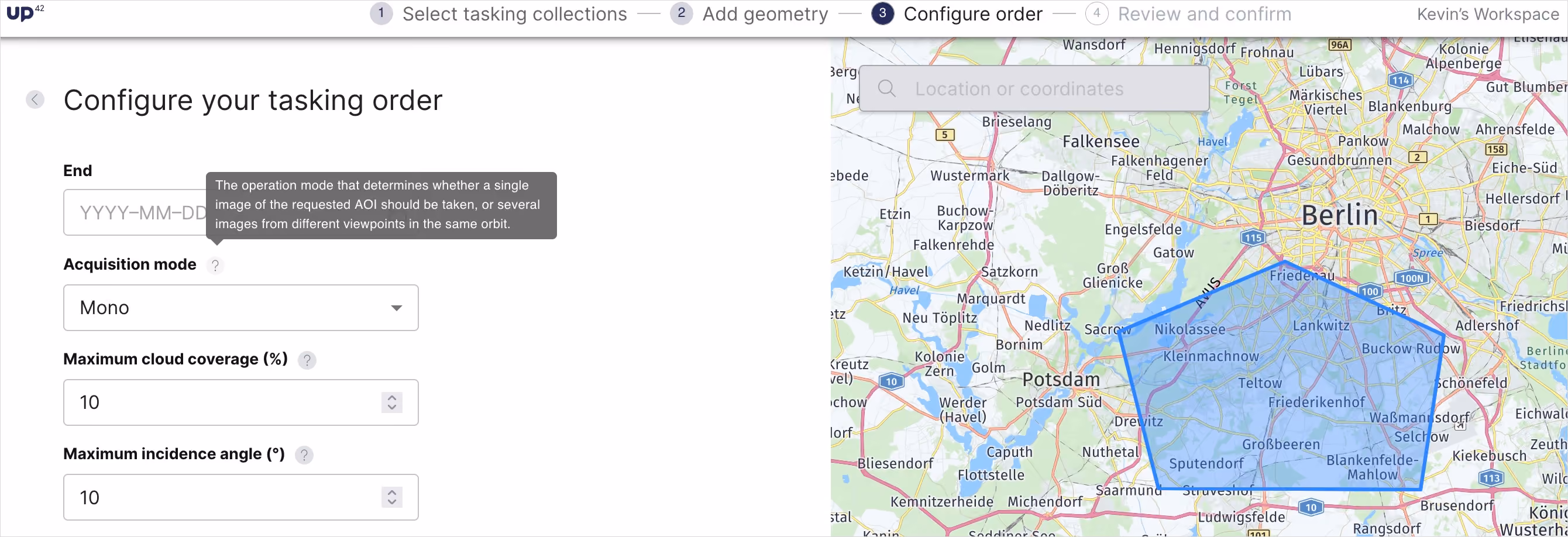
Once your order is placed, our operations team will work together with the provider on a feasibility study. They’ll then let you know if your order can proceed, or, if not, exactly what you can do to make it feasible.
The discover opportunities feature also helps with this by showing you potential time intervals when your selected sensor will pass over your AOI (please note that this feature isn't yet available for all collections.) And soon, you'll also be able to see which acquisition modes and image types are available from the provider selection screen.
2. Not enough transparency on pricing
Pricing: almost nobody’s favorite topic. But an essential one.
The vast majority of satellite companies that make their data commercially available don’t list prices on their site. You have to reach out to them, discuss what you need, and then negotiate. This makes for lots of uncertainty when you’re trying to plan out your budget.
How we’re solving this
UP42 uses credit-based pricing, where one credit is equal to one Euro cent. Our console shows each collection’s baseline price in credits, though it’s worth noting that we do discounts for larger orders.
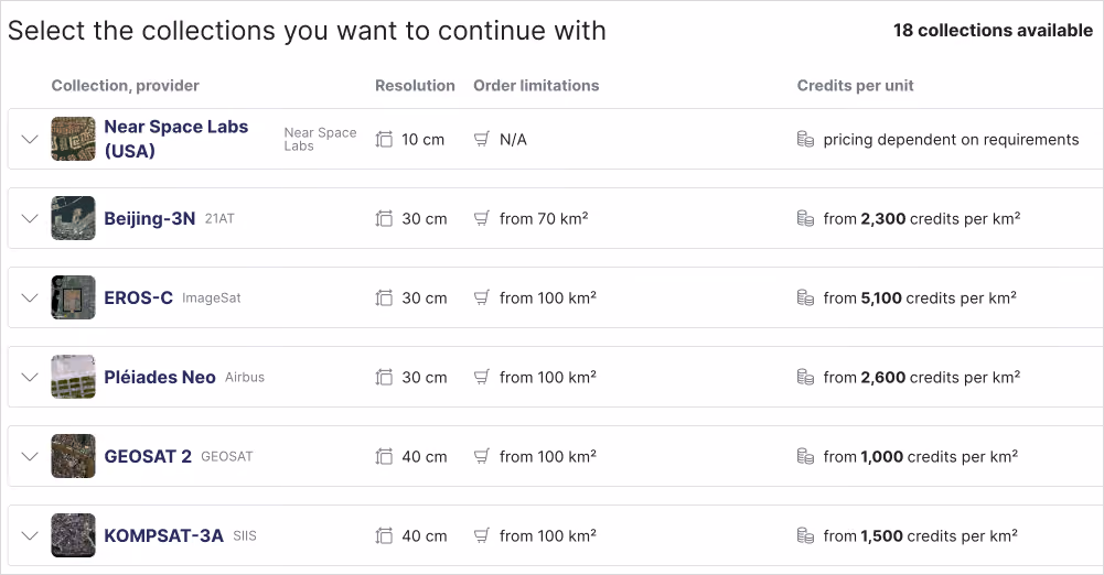
Once you’ve selected your AOI, you’ll then get an instant price estimate, as shown below, before you submit your order, so you can make sure the final price matches your budget. Note that there are still some factors that can impact the final price, including surface area, rush orders, and acquisition modes.

3. Inability to track order progress
Sometimes, tasking orders feel like you’re throwing them into a void. Once you’ve sent it, you have no idea what’s going on.
This isn’t ideal for scheduling or project planning, even if you’re given a rough idea of how long it might take upon submission. You should be able to see how much of your order is complete and how much is still remaining.
How we’re solving this
Our platform shows order completion in a few different ways: as a percentage, and overlaid on a map. This makes it easy to visualize how much of your order remains, and exactly which areas are finished.
But we take it even further. If you’re in a rush, and most of your desired AOI is complete, you can halt the order, download whatever is ready, and then get refunded for the remaining credits that weren’t used in your final order. You can also download the geometry for your unfinished AOI, and either use it in a future tasking order or search through archive imagery to see if it’s already been captured.
4. A lack of quality customer support
Even with a well-laid-out ordering page, there’s still a dizzying amount of options available when you’re trying to narrow down what you need for your project.
This is especially true if you’re not from the geospatial industry: while Earth observation data is extremely useful for a ton of different purposes, it’s really tough to figure out exactly what you need. And sometimes, your use case is best served by a few different types of data (like optical and elevation) instead of just one. But how would you know that in the first place?
How we’re solving this
The UP42 platform has extensive and comprehensive documentation, which we’re constantly updating to make sure everything is accurate. You’ll find tons of info about collections, tasking parameters, and more.
On top of documentation, our customer support team is also here to help out. They’re geospatial experts who can assist with choosing the right collection for your use case, as well as with multi-sensor support, if your order would be best suited with data from multiple providers. And if your order is made up of lots of complicated AOIs, they’ll guide you through every step of the process.
We've made massive strides in getting EO imagery into customer’s hands fast, with a minimum of manual effort and back-and-forth emails. And if help is needed, we’re here. Check out tasking on UP42 or contact our team today.


Subscribe to our newsletter
Stay up to date and learn about our fast-growing new features
