Satellite tasking at UP42: Place and track orders all in one place
Gone are the days when tasking a satellite for a specific location meant lengthy phone conversations and emails. Earth observation companies disrupted this process and reduced data delivery time to a few days, or even hours.
Satellite tasking is now available to all of us, and at UP42, we’re making it easier than ever to obtain new images. So we’ve brought all tasking actions together in one place. Whether you’re looking to place a new tasking order or monitor your request, it’s all possible with the push of a single button on the UP42 platform. Welcome to a new way to task a satellite!
Do you have a project and need new imagery?
Let’s assume you’re working on a new project that requires imagery of a specific resolution or type. If you can’t find the right archive data, you’ll probably turn to satellite tasking. This gives you the freedom to define exact parameters such as cloud coverage, processing level, image capture technique (like mono, stereo, or tri-stereo), and spectral bands, collecting the perfect image and supporting informed decision-making. This all sounds great. However, you might still face several challenges:
- You need to task satellites from different providers
- You have a fixed window of time to acquire the imagery
- You have budget constraints
How can UP42 help?
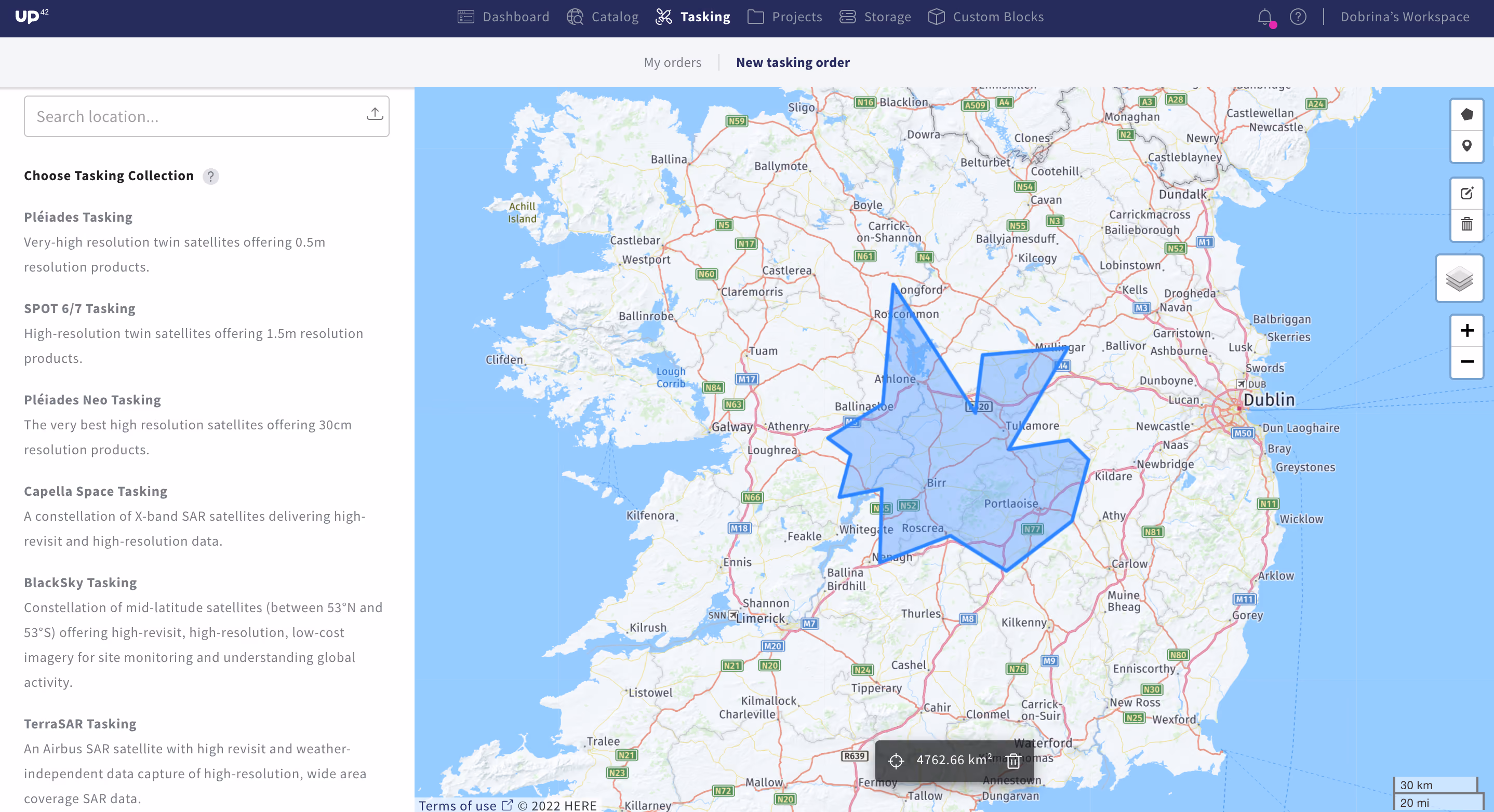
Placing a tasking order is now easier than ever with our new tasking tab. Go to 🛰 Tasking and click on New tasking order. If you are using a tasking collection for the first time, you will need to request access to it by selecting your collection. Let’s use Capella Space as an example. Click on Request Access to Capella Space Tasking, fill out the form, and press Submit.
Our customer support team will then come back to you. You can start your order by specifying your Area of Interest (AOI). Either draw an AOI by pressing the ⭓ icon on the top right corner and clicking on the base map, or upload your AOI by tapping the upload icon on the search bar. Next, specify your parameters. For your Capella Space order, for example, fill in your order name, acquisition window, mode, and polarization, and click Next.
Click on Submit Request. For some collections, a feasibility study is needed. This will be managed by our operations team who will look at parameters such as cloud cover, local climate, seasonal restrictions, acquisition interval, and incidence angle. You will then receive an email indicating if the order is feasible with the study as a pdf, if it requires modifications with suitable options proposed, or if the order isn’t possible. Our team will also coordinate acquisition schedules and work with you to ensure you have the best possible window to collect imagery. Once you accept the study, a price quote will be generated and sent to you via email. You can easily confirm your offer on the platform, in the My orders tab of the console.
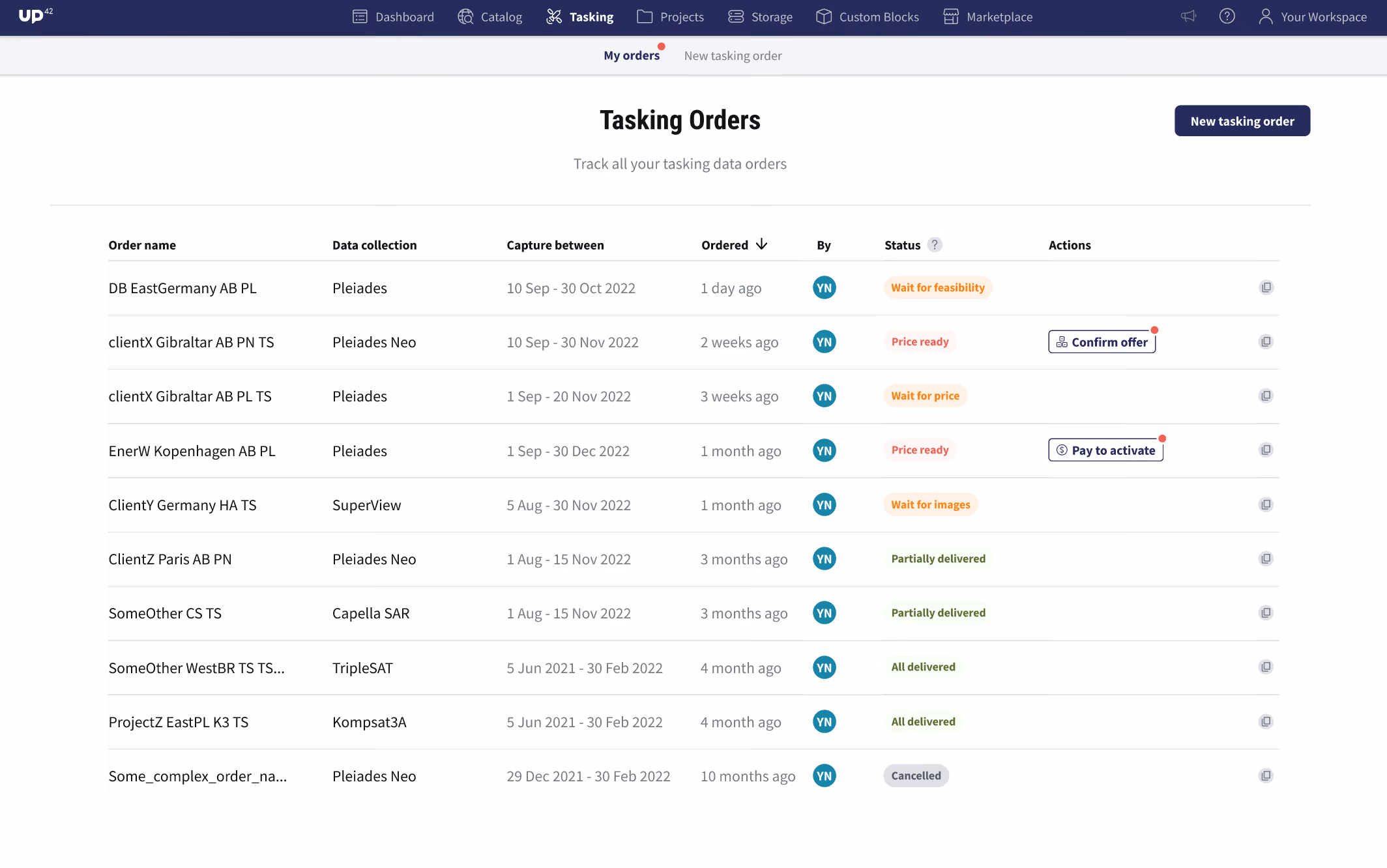
Stay informed by easily monitoring your orders
In addition to placing an order, you can also track the status of your order using our new tasking tab. Go to 🛰 Tasking -> My orders to find an overview of all your tasking orders, monitor their status, download assets, and process them. Selecting an order will automatically open up a sidebar with order information such as the AOI, order configuration, status of delivered data, and assets delivered for the order.

Being a developer-first platform, we give you the flexibility to use our console, API, or Python SDK. For a guide on how to task a satellite via our API or SDK, please see our documentation.
Need imagery from multiple providers?
Complex projects sometimes require tasked imagery from multiple providers that then need to be integrated into a single data pipeline. The UP42 tasking platform gives you direct access to satellites from Airbus, Capella Space, ICEYE, and BlackSky directly, so you can benefit from different spatial, spectral, and temporal resolutions.
Optical imagery is great if you want to see the world as the human eye does, making it more accessible and easier to digest and interpret. You can choose from:
- Pléiades Neo: acquired by four very high resolution optical satellites on a twice-daily basis, Pléiades Neo delivers 0.3m resolution with stereo and tri-stereo capacity.
- Pléiades: this constellation of very high resolution twin satellites has been designed for daily revisits anywhere on Earth, offering 0.5 m resolution with stereo and tri-stereo capacity.
- SPOT 6/7: high-resolution twin satellites offer 1.5 m resolution products and daily revisit frequency with stereo and tri-stereo capacity. They can cover large areas in a single pass, up to 100,000 sq km.
- BlackSky: a constellation of 14 satellites launched into a mid-inclination orbit provides a high revisit rate, resolution up to 0.83 m, responsive last-minute tasking, timely collect-to-data delivery latency timeframes, and stereo capabilities.
While optical sensors measure reflected solar light, radar sensors can penetrate through clouds and image both day and night in almost all weather conditions, making them great for persistent monitoring and change detection.
- Capella Space: this constellation of SAR satellites delivers a high revisit rate and high resolution data acquired globally on a sub-daily basis.
- ICEYE: acquired daily with four acquisition modes available, ICEYE tasking provides persistent monitoring using the largest operational constellation of SAR satellites.
- TerraSAR: acquired by two high resolution radar satellites (TerraSAR-X and TanDEM-X) every 11 days anywhere on the globe, and with six different imaging modes available.
Need to integrate data from multiple providers into a single data pipeline?
Now that you’ve acquired the imagery you need for your project, you can process it externally, or even better: on our platform, where you can easily analyze the data and collaborate with your team members. Data originating from your tasking orders is delivered to UP42’s cloud-based storage, where it will be available for further processing. Combine data from multiple providers, augment SAR with optical data and vise-versa, combine data with 3rd party analytics capabilities, or even bring your own data and algorithms. Your data is also available for integration with other ecosystems, such as QGIS or Esri. Existing Esri users can immediately access UP42 storage and projects directly from your ArcGIS Pro account.
Why task a satellite via the UP42 platform?
It’s faster and cheaper than a site visit. You get a view from above. You can detect changes or monitor progress. With the right team and infrastructure, UP42 is always ready to process urgent requests so you can obtain your data as soon as possible and stay on budget. With Earth observation increasingly being used in more advanced use cases, satellite tasking will become a natural part of the process. Watch this space as we continue to improve your experience, giving you the freedom and flexibility only satellite tasking can provide.

Subscribe to our newsletter
Stay up to date and learn about our fast-growing new features
