Solve your data management challenges with the UP42 ArcGIS Pro Add-in

We’ve had a busy year at UP42 so far. New and exciting data and analytics partners have joined our platform, offering high-quality geospatial data sets for different use cases. Now, we're looking downstream at the next big challenge - how do we make it easier for a geospatial user to access and visualize imagery that they’ve purchased through UP42?
On that front, we took a significant step forward last month: a new partnership announcement with Esri. As the leading provider of commercial proprietary geospatial solutions, Esri offers a suite of GIS and geospatial applications focused on mission-critical elements of a geospatial organization. ArcGIS Pro, in particular, is a powerful software used extensively for data analysis, visualization, and collaboration across companies and institutions focused on geospatial projects.
That’s why we’ve worked together to launch the UP42 ArcGIS Pro Add-in. The add-in is a simple tool that lets you connect both accounts within seconds, enabling you to access your UP42 storage and projects directly from ArcGIS Pro.
An easier way to access and visualize data
For all the progress made in the geospatial world over the past few years, getting the right data still remains a complex process. Whether you’re a data scientist at a 10-person startup or a GIS analyst working for a big enterprise team, data access remains one of the biggest hurdles to getting a project off of the ground.
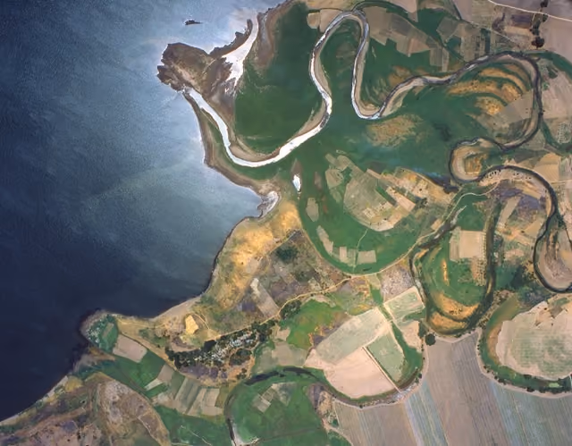
Let's consider the case of a team of GIS analysts working on a remote sensing project. Once they’ve defined their area of interest, they usually need multiple external geospatial data providers to purchase this imagery.
This is where things get tricky, because there’s no "standard" way to go about things from here on. Some areas of interest might not have any associated archive imagery, or existing images might be of poor quality. In this case, the team has to approach a data provider to task new imagery and ensure that the output fits their technical requirements. New projects may also require data with varied technical specifications - imagery with different resolutions, processing levels, and spectral bands, for example.
This is exactly where UP42 comes in. With our unique platform and marketplace offering more than 170 geospatial datasets through a single touchpoint, we erase the biggest headaches for our users.
This new integration offers an intuitive, streamlined way for users to access the imagery assets purchased on UP42 directly from ArcGIS Pro. Users can get started in seconds by downloading the add-in for free from the UP42 or Esri marketplace. Our extensive documentation also walks you through the setup.
Once the integration is complete, you can open UP42 storage and projects, directly within your ArcGIS Pro environment. Users can open existing projects, download purchased data sets into ArcGIS Pro, and also view the metadata associated with purchased assets. This offers a simplified, intuitive process for businesses to handle large volumes of geospatial data. It dramatically reduces data management challenges by removing the need to constantly switch between tools.

After opening the purchased assets on storage, you can add them to your base map on ArcGIS Pro. This integration facilitates a simplified workflow that lets you order the imagery you need for your project, visualize it on ArcGIS Pro, and then build custom solutions based on your specific business requirements.

What we’re planning next
Our product integrations team is already working hard to release the next version of the add-in. In V2.0, you can expect much more functionality, including searching through the image catalog and placing orders directly from your ArcGIS Pro account.
Watch out for new updates coming soon, as we look at new ways in which we can tackle some of the biggest pains for geospatial users.

Subscribe to our newsletter
Stay up to date and learn about our fast-growing new features
