


Earth observation data plays an important role in enhancing our capability to understand the Earth. Information derived from the data informs, among others, agricultural practices, environmental monitoring, and climate change mitigation efforts.
But storage, access, analysis, and management of Earth observation (EO) data presents difficulties.
Specifically, collecting and managing large amounts of EO data from multiple sources–delivered at different times–is challenging. More so for traditional workflows, which are often characterized by the user downloading EO data on their computer.
For such traditional workflows, previously purchased datasets may be inaccessible, leading to multiple purchases of the same data. In addition, further analysis or integration with other datasets may be cumbersome. Ultimately, traditional workflows are costly and may lead to delayed decision-making.
To reap the benefits of EO data, we need to deal with data storage and access challenges.
UP42 storage aims to address these challenges.
What is UP42 storage?
UP42 storage is a cloud-based storage space that centralizes access to purchased EO data and the processing algorithms that go with it. It enables you to access and manage geospatial data arising from archive or tasking orders on the UP42 platform.
Storage brings together past and current datasets into one place, making it easy to integrate them into your workflows.
So, how do you get started with UP42 storage? But maybe more importantly: why should you get started? Because UP42 storage offers the following advantages:
-
Around-the-clock access to geospatial datasets so you can use your data anytime and anywhere.
-
A single point of access to all your UP42 orders means your team members can easily access and integrate the datasets into their workflows, eliminating data duplication for more efficient use of storage resources.
Access UP42 storage by logging into your UP42 console and clicking on the Storage tab. Our detailed guidelines will help you navigate storage for archive orders or tasked datasets.
Let us now look at the specific benefits you can expect once you log into UP42 storage.
What can you do with UP42 storage?
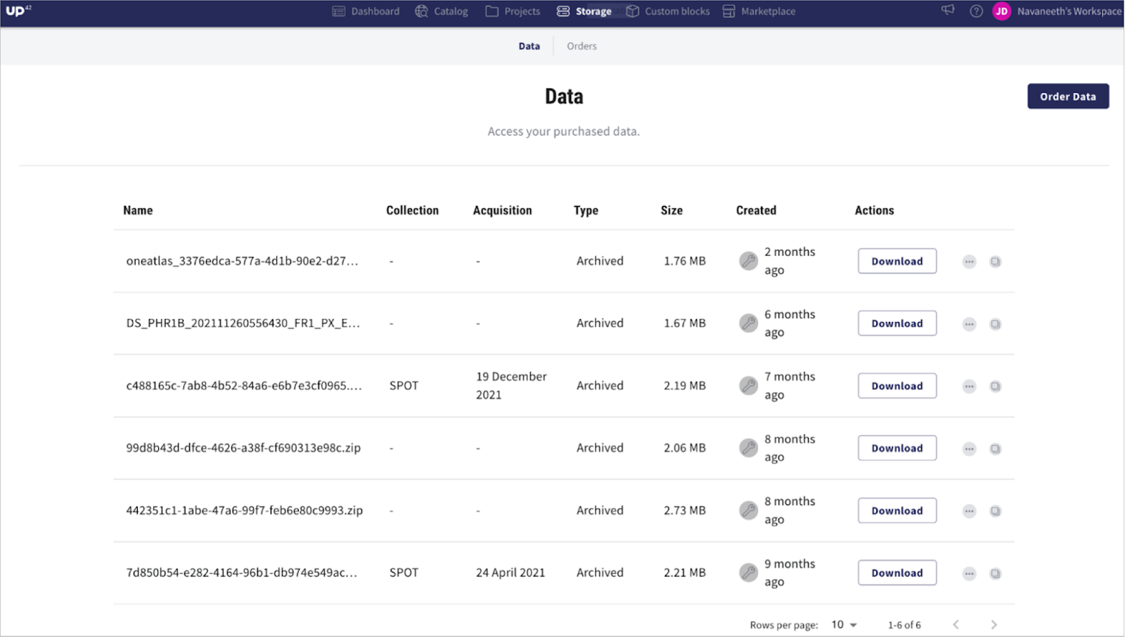
View previously ordered geospatial datasets
By default, clicking on the Storage tab takes you to the Data tab. Here, you can view a list of archive datasets previously ordered via the catalog, or through satellite tasking.
Storage enables a central point of discoverability for your orders. You, therefore, spend less time gathering data from multiple storage sources and more time discovering insights–for an efficient decision-making process.
In addition, you can integrate previously downloaded archive data, with fresh images in your workflows, adding value to your results.
What else can you do with previously ordered geospatial datasets delivered in UP42 storage? Let us find out.
Download datasets and view metadata
Recognizing that you may need to:
-
View or undertake further data analysis using a specific software;
-
combine the data stored in UP42 storage with internal data sources;
-
access the data offline;
-
or share the data with others outside your organization;
UP42 storage enables you to download the datasets associated with a particular order by clicking the Download button.
But before you hit download, it may be a good idea to view the metadata.
Metadata describes your data to enable better understanding, management, and use of that data. In short, metadata provides context about your data. For example, the metadata displayed in UP42 storage includes the name of the originating satellite sensor, acquisition date, whether it arose from a tasking or archive order, file size, etc.
In UP42 storage, the name displayed against your dataset is a unique ID generated with each successful order. While the ID is useful when processing directly from the storage (e.g., through a workflow), it does not tell you much about the data. Viewing metadata ensures you avoid the unfortunate situation of downloading/ processing unintended data.
Display metadata by pressing the three dots and selecting Image information.

Pressing the three dots also gives you the option to preview, which we look at next.
Preview an image footprint
When looking through the list of datasets delivered to your storage folder, it may be hard to tell their respective areas of coverage and location. Previewing the image footprint is a good way to ensure that you choose the correct datasets before downloading or processing.
Where do you start?
Click on Preview after pressing the three dots (

The base map is automatically zoomed out to provide context and thus enable you to determine the general location of the selected image.
Process delivered datasets
Turning the delivered datasets into value calls for some degree of processing. UP42 storage provides you with two ways to do this.
Option 1: Process datasets from storage
Processing from UP42 storage means you get to process the delivered datasets without the hassle of downloading. Besides saving on costs associated with in-house storage, going with this option lets you take full advantage of the UP42 platform, namely:
-
Paying for storage and CPU processing infrastructure only when needed–effectively gives you the flexibility to scale up or down depending on your requirements.
-
A selection of over 80 ready-to-use processing algorithms. You, therefore, do not have to build and train an algorithm from scratch–reducing the time between data delivery and insights.
-
The option to combine the delivered data with a variety of other data sources–be it radar, optical, or elevation–in your workflows, enhancing your insights.
Check out our process datasets from storage step-by-step guide to learn how to process geospatial datasets delivered to your storage folder.
But what if you want to process the delivered datasets using external tools? Well, this is where option 2 comes in.
Option 2: Download datasets and use 3rd party tools like QGIS or ArcGIS Pro
To leverage the capabilities of 3rd party tools to visualize or analyze your data, you first need to download the datasets from UP42 storage and save them locally.
If you are using QGIS, this guide walks you through visualizing the downloaded datasets.
If your tool of choice is ArcGIS Pro, you do not have to download the datasets separately. This is because we have recently introduced the UP42 ArcGIS Pro Add-in. You can now access UP42 storage and job run results directly from your ArcGIS Pro account.
That's right. No more switching between UP42 storage and ArcGIS Pro. Just easier access to your UP42 storage datasets so that you can leverage ArcGIS Pro analysis capabilities to enrich your applications and projects.

Discover how to access UP42 data directly within ArcGIS Pro.
Finally, as you await data delivery, you can:
Monitor the status of your archive and tasking data orders
UP42 storage keeps you informed of the status of your active and past data orders. This way, you can track your order at any given moment.
From the moment you place your order until delivery, clicking on the Orders tab gives you a transparent view of your order status–which may be marked as In Progress or Completed.

Completed data is already delivered to storage and can be viewed by pressing the Data tab.
When a tasking dataset is delivered, you will receive an email notification with information about the order, the delivered file, and a link to storage to download the data.
Note: If you are a developer, you can use Webhooks to alert you whenever the status of your data order changes. How do you do this? See Event Notifications With Webhooks.
Take advantage of UP42 storage
As EO technologies evolve, managing, storing, and analyzing geospatial data will become increasingly important.
Fortunately, cloud computing technologies enable ubiquitous, on-demand access to EO data and scalable computing resources. Cloud computing opens exciting new possibilities for extracting actionable knowledge for responding to global challenges.
At UP42, we strive to power geospatial innovation by making it not just possible but easy to access and process geospatial data. To achieve this, we have simplified data ordering, tracking, and download, enabled integration with processing algorithms, and provided scalable infrastructures.
With accessible data and analytics and a support team excited to help you, extracting your insights has never been easier. Take advantage of UP42 storage today.


