


Even 40 years ago, it would have been impossible for the average person to get their hands on satellite imagery. Governments, and by extension, their militaries, claimed sole dominion over space, only releasing tidbits to the press to show off their achievements.
By the 90s, the world's situation shifted. The Cold War had officially ended, and Russia realized that their valuable satellite imagery could become a new source of income. In 1992, they began selling it to the highest bidder. In 1994, the United States took this a step further, allowing private companies to build and launch their own satellites.
That didn't mean that obtaining satellite imagery as a civilian was easy. If you wanted images (to monitor infrastructure or vegetation, for example), it was a painfully bureaucratic and drawn-out process. By the time you got your imagery, it might no longer be current. And it stayed that way for years.
The IKONOS-2 satellite, launched in 1999, was the first high resolution satellite that could be tasked by commercial entities. And now, with satellite tasking made possible through browsers, brand-new high definition satellite imagery is more accessible than ever.
What is satellite tasking?
Satellite tasking is what happens when you request for a satellite to capture your designated Area of Interest (AOI).
Commercial satellites cover the majority of the world's lands and oceans. Depending on each satellite's revisit rate, it may be able to take an image of a specific area as often as several times per day, or as rarely as every 5 days or more.
This means that there's plenty of historical imagery available. But if you need up-to-date imagery, then satellite tasking is your best bet.
It's also possible that certain types of historical imagery may exist for your AOI, just not the types that you need. Which leads us to...
What types of satellite imagery can I get with satellite tasking?
Broadly speaking, satellite imagery is divided into two distinct types: optical and radar.
Satellite tasking for optical imagery
Optical satellites take pictures to capture your AOI. One major benefit here is that optical satellites can see parts of the spectrum that aren't visible to the human eye, such as infrared and ultraviolet. This allows optical satellites to measure things like vegetation health and ocean heat levels.
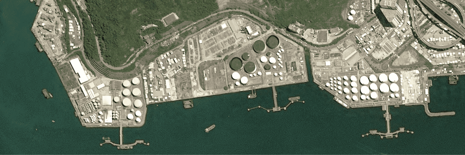
The most common use for optical imagery is mapping—just think Google Earth, which made satellite imagery available to the public on an unprecedented scale. But Google Earth's resolution varies wildly. Likewise, its revisit rate is inconsistent, and can be incredibly slow: some areas don't get updated for years. If you're monitoring construction or infrastructure, you probably need more reliable images.
In contrast, many of the optical satellites on the UP42 platform boast high or very high resolution rates, along with high revisit rates. For example, the Pléiades Neo constellation, along with the Pléiades, Superview, Earthscanner, and Satellogic constellations, are very high resolution (below 1.5m resolution) and offer daily revisits. A custom tasking operation with one of these constellations will get you brand-new very high resolution imagery at speed.
There are a couple of drawbacks to optical imagery. First off, optical satellites can't penetrate cloud cover. So a single image of a cloudy area won't show you much; you'd need repeat images, taken at different times. Second, optical satellites need light, making them heavily dependent on the day/night cycle. But that also makes them cheap compared to our second type.
Satellite tasking for radar imagery
Radar satellites get their imagery by sending beams of radiation towards Earth, and collecting the reflected signals.
These kinds of satellites aren't reliant on light, so they can take imagery at any time of the day or night, which gives them an advantage over optical satellites. They can also penetrate cloud cover, so they're useful for taking images of areas that are frequently obscured by clouds or mist: with radar, you'll only need to task a satellite once to get a guaranteed picture of your AOI, instead of needing repeat visits like you would with optical satellites. Some types of radar, such as LiDAR (Light Detection And Ranging), can even penetrate dense forest canopies.
Radar imagery is useful for a whole host of reasons, from recording the height of objects (both human-made and natural) to measuring air and water quality.
How do I define my AOI when tasking a satellite?
If you're tasking a satellite on the UP42 platform, you have a few different ways to define your AOI.
The first two ways are directly within the UP42 console. Here, within the catalog, you can click to define your AOI by creating a polygon in any shape that you desire. You may also upload a geometry file directly into the console.
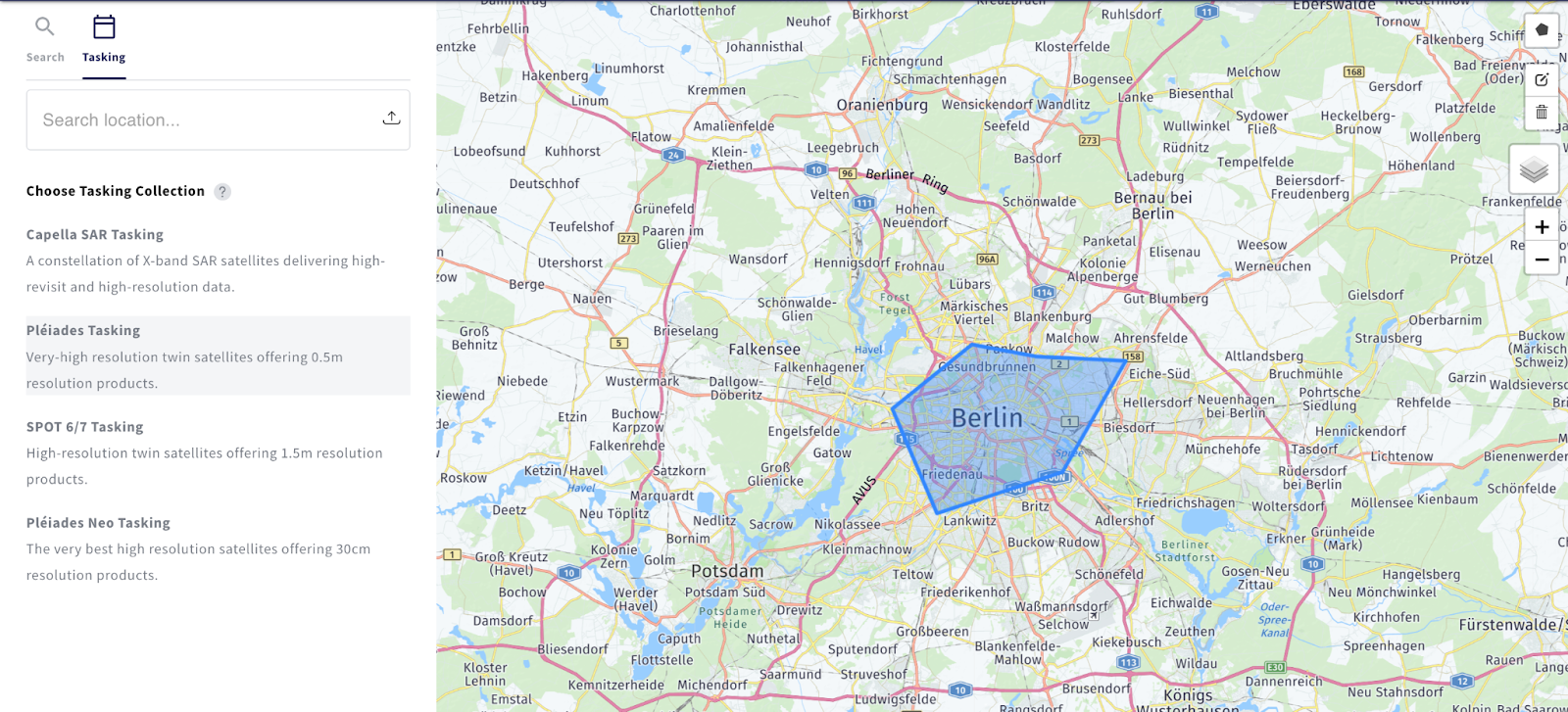
Once you've defined your AOI, the tasking option on the right sidebar will show you which satellite constellations are available. At this stage, you'll be able to use the dynamic tasking form to define specific acquisition parameters, along with start and end date, cloud cover, and incidence angle.
You may also task a satellite via API. For a guide on how to do this, please see our documentation on satellite tasking data discovery (API).
What happens when I task a satellite?
When you task a satellite, whether through the console or via API, the data order goes to UP42's customer support team.
Our team will look at the feasibility of the tasking request, including all the involved parameters, from cloud cover and local climate and seasonal restrictions to acquisition interval and incidence angle. If the order is feasible, the customer support team will then provide a quotation with a final price.
If agreed upon, the tasking operation activates and will begin on the specified date. You can monitor your order within the console, or by API. Once your order is ready, you may download your data as a ZIP file.
Things to watch for when tasking satellites
Want to ensure that your tasking operation runs as smoothly as possible? Here are a few tips.
-
When it comes to your AOI, make sure that your first and last vertices (selection points) are identical, and that you have no duplicate vertices.
-
The polygon that forms your AOI should not contain any holes or self-intersections.
-
Your AOI shape shouldn't be overly complicated. We recommend a maximum of 1000 vertices.
Ready to get started? Head over to our console. Whether you need optical or radar satellite imagery, we've got a wealth of sources available. You can easily explore the different options before you place your order.


