What’s new
Release notes
Keep up with the latest releases and improvements.

Major console upgrades completed
We’ve made some behind-the-scenes upgrades to our infrastructure to help improve user experience and site reliability, ahead of some great new upcoming features.
Automatic email notifications for tasking delivery
We’ll now automatically send you an email notification when a new data asset is ready for your tasking order.
Console Version Update
We’ve been working hard to ensure that you can quickly find and download the geospatial imagery you need. On that note, we’re releasing a new version of our console for UP42 customers. What does that mean for you?
Previously, there were two separate workflows with a differentiation between Purchase and Processing data sets where Processing data sets could be processed directly from the UP42 platform. With this release, we’re removing the Processing workflow altogether. This will simplify the search and order process for our users.
Please note that due to these changes, our OneAtlas archive datasets are scheduled to be unavailable on May 5th from 11:00 CET to 16:00 CET. We apologize for any inconvenience this may cause and look forward to you benefiting from a more seamless experience with these updates.
Shiny New SDK Version 0.18.0
If you haven’t already used the UP42 python SDK, today’s a great day to start as we’ve released SDK version 0.18.0 which entails significant speed & usability improvements when handling large orders, assets, jobs and more. Some of the high-level advantages you’ll enjoy include:
- Ability to add sorting criteria
- Results pagination to avoid timeout issues when querying large asset/order collections
- Significant speed improvements
If you have used our SDK before, simply update via pip install up42-py --upgrade
Some other things to note is this update means the end to the Python SDK Command Line Interface (CLI) as well as removing deprecated handling of multiple features as input geometry. For the latter point, multiple features or a MultiPolygon will now raise an error with the SDK, aligning with regular UP42 platform behavior. See the full changelog here and delve deeper into how this update facilitates your processes.
Tasking Direct from the Catalog
Tasking can be a complex process with lots of back-and-forth, often requested and delivered via email. Gone are the days of being restricted to scouring through your email inbox to see if you sent in that tasking request or if your data’s arrived yet. Customers now have the ability to choose and order data from the different archives of our providers or schedule a tasking request all in the same route on different tabs, which effectively makes it a “one stop shop” for all things data related. Access requests can be made to different collections, namely Pleiades, SPOT, and Pleiades Neo.
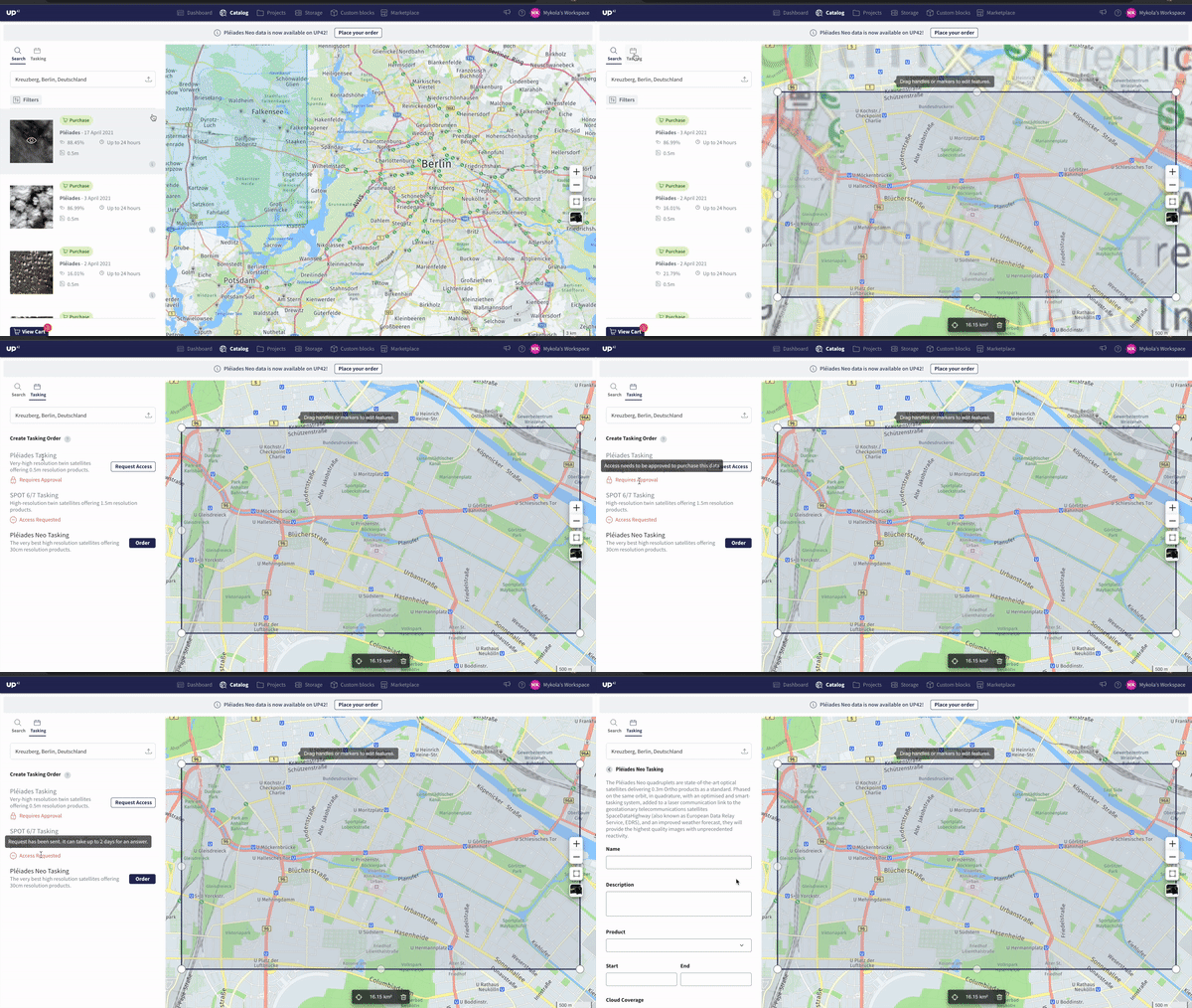
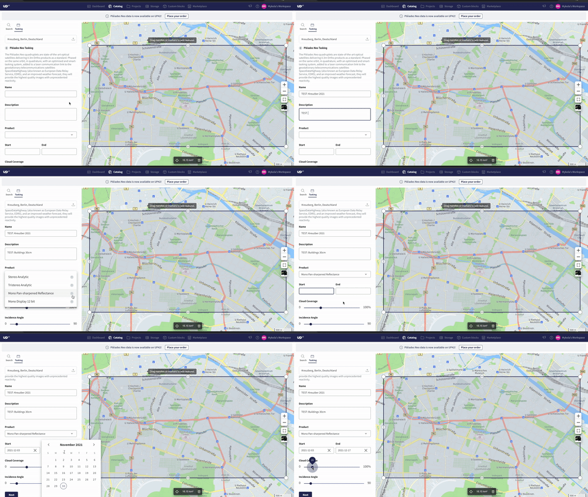
The steps to place your order from the UI are straightforward. Simply navigate to the tasking panel from Catalog Search, select the constellation you'd like to task, add in your necessary information like imaging window and product name, and submit your request.
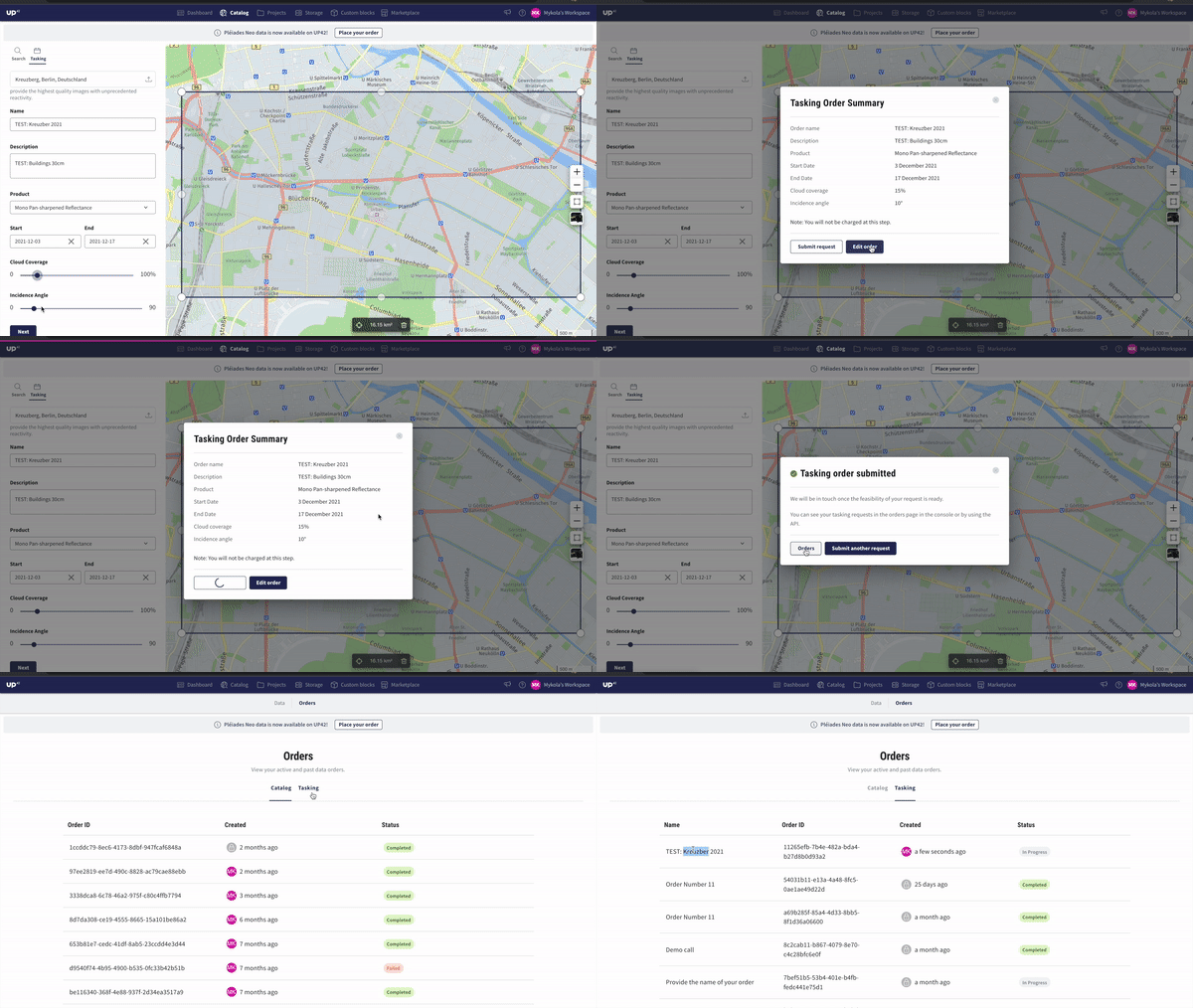
Once the order is placed, it would be visible on the Orders page of the console, under tasking and of course through the new Tasking API.
Here are some helpful links to get you started:
Use Your Tasking Data Like a Pro
Just like with archive data that you order, you can use tasking data from UP42 in workflows with the Processing From Storage block as the data block.Simply build an UP42 workflow using the Processing From Storage block as the data block followed by any compatible processing block. In this example, we are simply converting data from my storage, the output of a Pleiades download block, from DIMAP to GeoTIFF.
As we move from the workflow builder to setting the parameters in the job configuration screen, we simply need to paste the Asset ID into the job parameters enclosed in [“asset ID”], select “Live Job”, and if necessary, adjust the parameters of your processing block(s).
Explore the UP42 platform
Create an account to order, access, and analyze geospatial data.
