


Aerial data from Getmapping, UK’s leading provider, could be just the solution you need for very high-resolution imagery.
We have partnered with Getmapping to bring you the first aerial datasets on the UP42 marketplace- Getmapping’s 12.5 cm resolution and 25 cm resolution aerial blocks in RGB. This new type of data will empower UP42 customers to explore a variety of use cases at some of the highest resolutions available in the market.
Aerial imagery fosters many vital applications of remote sensing, with a sophisticated range of cameras being used to collect information on land use, agricultural management, forestry, pollution and conservation, urban planning, wildlife management, and more.
With over 20 years of experience, Getmapping has an extensive repertoire of datasets and solutions of the highest quality. Getmapping is the UK’s leading supplier of aerial photography and also offers high-quality mapping products and data hosting solutions.
Why choose aerial?
A key advantage of aerial photography is that oftentimes it is captured at relatively low altitudes, thereby capturing fine detail and achieving spatial resolutions that far exceed satellite data capabilities.
Perhaps just as significant as spatial resolution, depending on the project, is the temporal resolution or historical component of aerial data. While the revisit is often less frequent, the ability to look back historically with aerial data surpasses that of satellite data, especially at the spatial resolutions achieved by Getmapping. This unlocks many use cases for exploration which were not achievable on the UP42 platform before!
Some of the types of imagery datasets in Getmapping’s repertoire include Oblique, LiDAR and more, while the first two datasets now available on UP42 are Vertical imagery as depicted below.
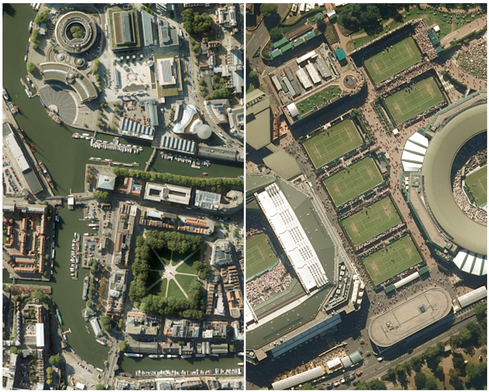 Above: A 25 cm resolution RGB image of Bristol depicted on the left with a 12.5 cm resolution RGB image of Wimbledon depicted on the right.
Key Advantages:
- Select data at the some of the highest resolutions available on the market.
- Access both fresh and historical aerial photography in one convenient location (image acquisitions date as far back as 2000 for Getmapping aerial data!)
- Easily combine the highest resolution imagery with the functionality of UP42 and compatible algorithms
- Extract valuable insights and train algorithms without hassle thanks to Getmapping’s high quality pre-processing
As an added bonus, Getmapping can also provide bespoke Aerial Surveys where off-the shelf footage is not available, all at an affordable price.
What can you expect regarding coverage?
Getmapping’s aerial data blocks have limited coverage (i.e. it is not globally available). As shown below, the 25 cm resolution block covers the entire extent of Great Britain (Scotland, England and Wales) while the 12.5 cm block covers the majority of England and Wales as well as some southerly parts of Scotland.

Limited coverage, such as the case with these two aerial blocks, implies restrictions for the functionality of data blocks regarding AOI selection and data access. Therefore, UP42 has also released a new Coverage Map feature, now available on the user interface. The Coverage Map feature helps with data discovery so you can easily see the extent where data collections are available. The coverage map will display the block's available data, both in Catalog Search and in Job Configuration. As depicted below, you will see a blue area for the available coverage and your AOI cannot be selected outside of the coverage. At least one point has to lie inside the coverage map for results to be returned. An example of how this looks from the UP42 console is depicted below.

 Above: An invalid AOI request for a given restricted coverage data block with a valid AOI request for the same block as a comparison.
This is a great leap forward as we look toward expanding the data selection on UP42. We're looking forward to seeing the algorithms and use cases that can now be supported with Getmapping’s aerial data.


