


Aerial imagery is one of the earliest forms of remote sensing. With origins in 1858, thanks to French balloonist Gaspard-Félix Tournachon, it has evolved from balloons and kites, to drones and airplanes.
Today, it remains one of the most widely used and cost effective methods of remote sensing.
If you’re looking for aerial imagery and need a refresher on what it is and where you can find it, you’ve come to the right place.
What is aerial imagery?
The term aerial imagery refers to all imagery taken from an airborne craft which can include drones, balloons or airplanes.
This bird’s eye view of the world is known as an aerial perspective. By placing ourselves in the air and looking down, we are able to create aerial photographs.
Aerial and satellite imagery
Aerial and satellite data complement each other in terms of what they offer.
Satellites provide high temporal resolutions, often with regular revisits over the same area of the globe. On the other hand, aerial imagery offers incredible spatial resolution —up to 1-5 cm per pixel.
The field of view covered in an aerial photograph is much smaller compared to satellite images. This is since satellites orbit the Earth and have global coverage, whereas aerial data providers conduct survey campaigns over niche areas that they serve.
Due to these differences, the kinds of projects that you can use aerial and satellite imagery for vary depending on what you’re looking to do.
For example, satellite images have greater large-scale applications thanks to its high temporal resolution, while aerial photography is great for more localized applications that make the most of its high spatial resolution.
This complementary relationship between the two makes aerial and satellite data both powerful sources of useful geospatial information. Find them on the UP42 platform to explore each of them more.
What are the different types of aerial imagery?
Aerial photography is classified into three different types according to the camera axis, scale of the image, and the type of sensor used:
Types of aerial imagery based on camera axis:
Vertical aerial photographs
The camera axis is in a vertical position in vertical aerial photos. Most often used in mapping, there is no tilt in the camera and a smaller amount of area is imaged.
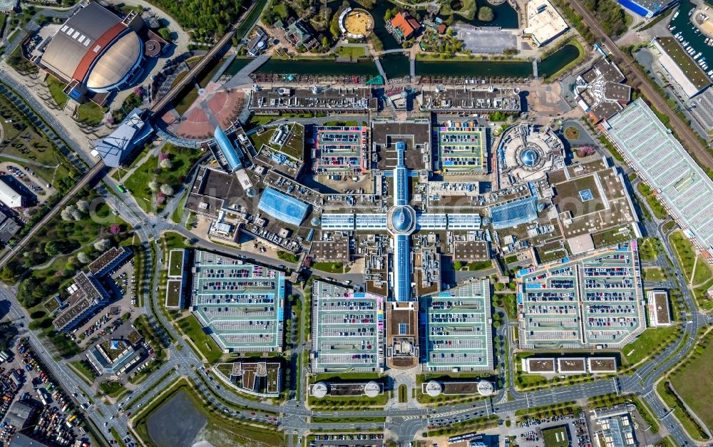 A vertical aerial photograph of the Centro shopping mall in Oberhausen, Germany (Source: © euroluftbild.de/Hans Blossey)
Low oblique aerial photographs
Low oblique images are taken by tilting the camera axis more than 3°. These photos are taken with an intentional deviation of 15° to 30° in the camera axis from the vertical axis. The horizon is not visible in low oblique photographs.
 The camera axis is tilted by more than 3° in low aerial photographs
High oblique aerial
With high oblique photographs the camera axis has a higher degree of tilt. The camera angle is intentionally inclined at around 60° from the vertical axis. In high oblique aerial photos, the horizon is visible and a larger area of land can be photographed.
 In high oblique aerial photographs the horizon is visible
What kind of aerial photograph to use?
When it comes to deciding which type of aerial photograph to use, it depends on the purpose you’re using it for.
Oblique aerial imagery is helpful to reveal topographic details of the land—useful for geological or archelological investigations. Low and high oblique imagery is often used in reconnaissance surveys. Oblique can also be used for 3D models.
Users often combine images of the same area from two or more different directions and use analysis techniques that yield 3D models. These images are called ‘stereoscopic images’—’tri-stereo’ for three directions, or ‘stereo-image pairs’ for two directions.
On the other hand, vertical photographs are better for mapping and most object detection use cases.
Types of aerial imagery based on scale:
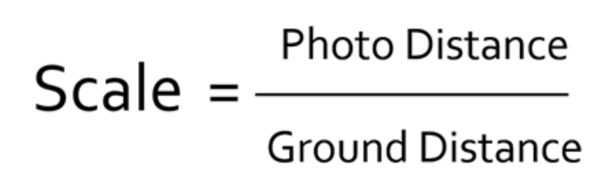
Aerial photographs can also be classified on the basis of scale. The scale of an aerial image is the ratio of the distance in the photo, compared to the corresponding distance on the ground.
So, if the scale of an aerial image is known then the lengths and areas of features can easily be calculated. This is done by measuring the distance on the photo (photo distance) and multiplying this by the scale factor—which is always equal to the ratio of the photo distance to the ground distance.
Aerial imagery scales determine what area of land is covered by the photograph and in how much detail.
There are three main types of aerial photographs based on scale:
Large scale aerial photographs
When the scale of an aerial photograph is 1:15,000 or larger, it is a large scale photograph. These photos are taken at lower elevations and (despite the name) less of an area is captured—but seen in a bigger dimension. That’s why low elevation aerial imagery is known as large scale imagery—making it more useful for measuring objects and mapping features.
Medium scale aerial photographs
Aerial imagery with a scale ranging between 1:15,000 and 1: 30,000 is usually referred to as medium scale photographs.
Small scale aerial photographs
This kind of aerial imagery has a scale that is smaller than 1:30,000. Small scale imagery covers larger areas, in less detail. It is ideal for studying relatively large areas with features that you’re not looking to measure or map in great detail.
Types of aerial imagery based on sensor:
There are many categories that aerial photographs belong to, depending on the type of sensor used. They vary in properties and can be used in a variety of ways:
Black and white panchromatic imagery
Black and white panchromatic sensors record the amount of light reflected by objects in varying tones of grey between black and white. It is useful for photogrammetry, as well as pan-sharpening when capturing higher resolutions at faster speeds.
Natural color imagery
This type of aerial photography replicates colors as seen by the human eye, and is a great base layer for land planning and creating soil maps. Color photography is also helpful to map vegetation or other tasks that benefit from color separation.
Infrared or thermal imagery
Infrared sensors are sensitive to infrared waves, in the spectral region of 0.4 micrometers to 0.9 micrometers. Available in black and white, color, and thermal—infrared is useful for taking photographs at night if there is a source of infrared radiation, as well as studying bodies or water or vegetation.
Radar imagery
Radar remote sensing captures reflected radar waves by sending out pulses of microwave electromagnetic radiation from an ‘active’ sensor. Radar photographs often contain noise and require corrections. Radar imagery is ideal for weather analysis, 3D analysis, and terrain monitoring.
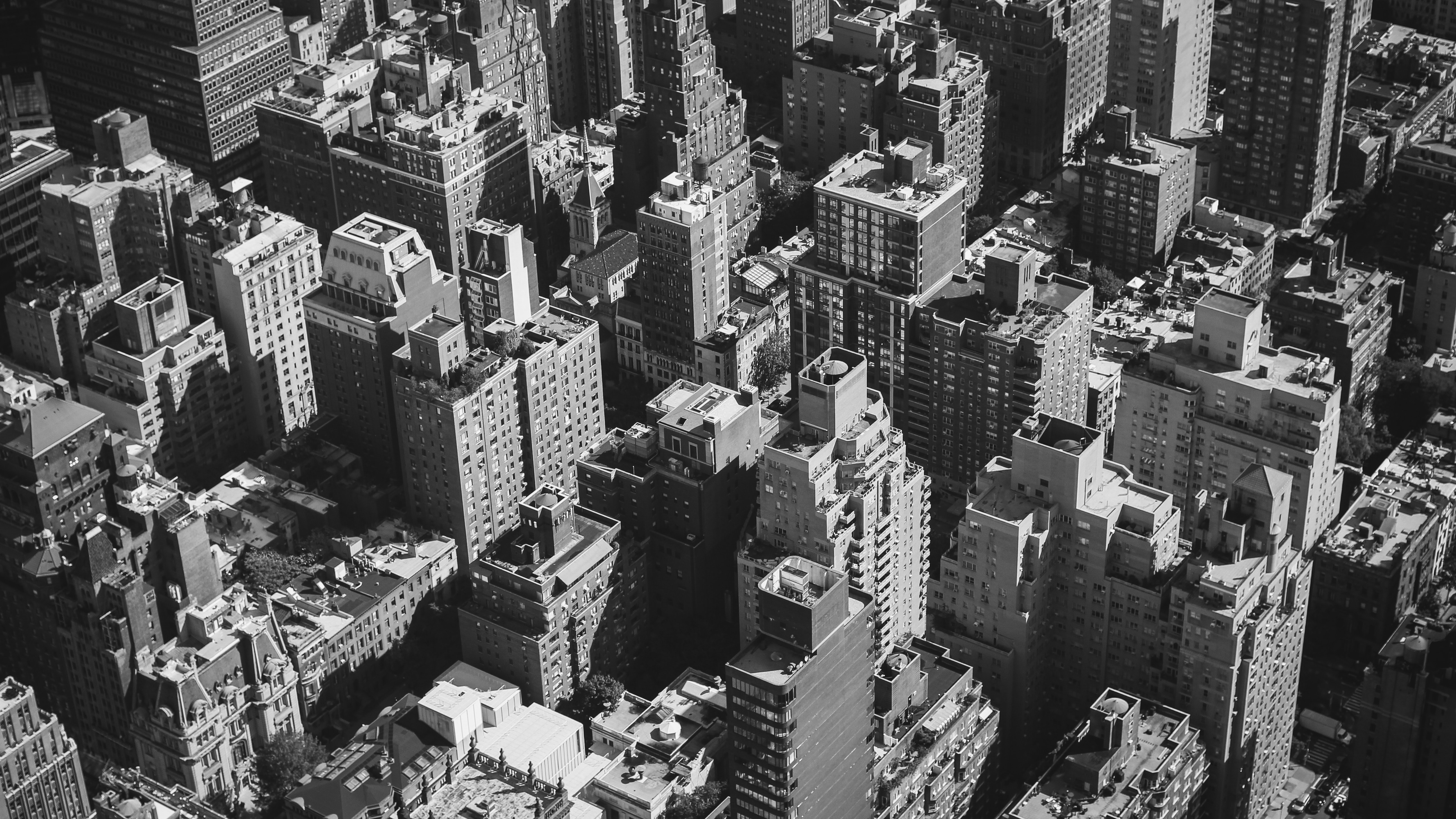 A black and white panchromatic aerial photograph of New York
Sources of aerial imagery
Now that we’ve covered what aerial photography is, how can you purchase aerial imagery?
There are many providers of aerial imagery, a few of which we’ve listed below:
Getmapping
Founded in the UK in 1999, Getmapping has over 20 years of experience in the provision of aerial photography, as well as high-quality mapping products and geospatial solutions across Europe and Africa.
The company produces their own vertical aerial photography, oblique photography, point-cloud and height data derived from aerial and mobile mapping survey programmes. They use reality capture to create a true digital twin, with a wide range of 2D and 3D datasets.
Getmapping has two vertical aerial data products available in 12.5 cm and 25 cm resolution, easily accessible on the UP42 marketplace.__ As an added bonus, Getmapping can also provide bespoke Aerial Surveys where off-the-shelf footage is not available, at an affordable price.
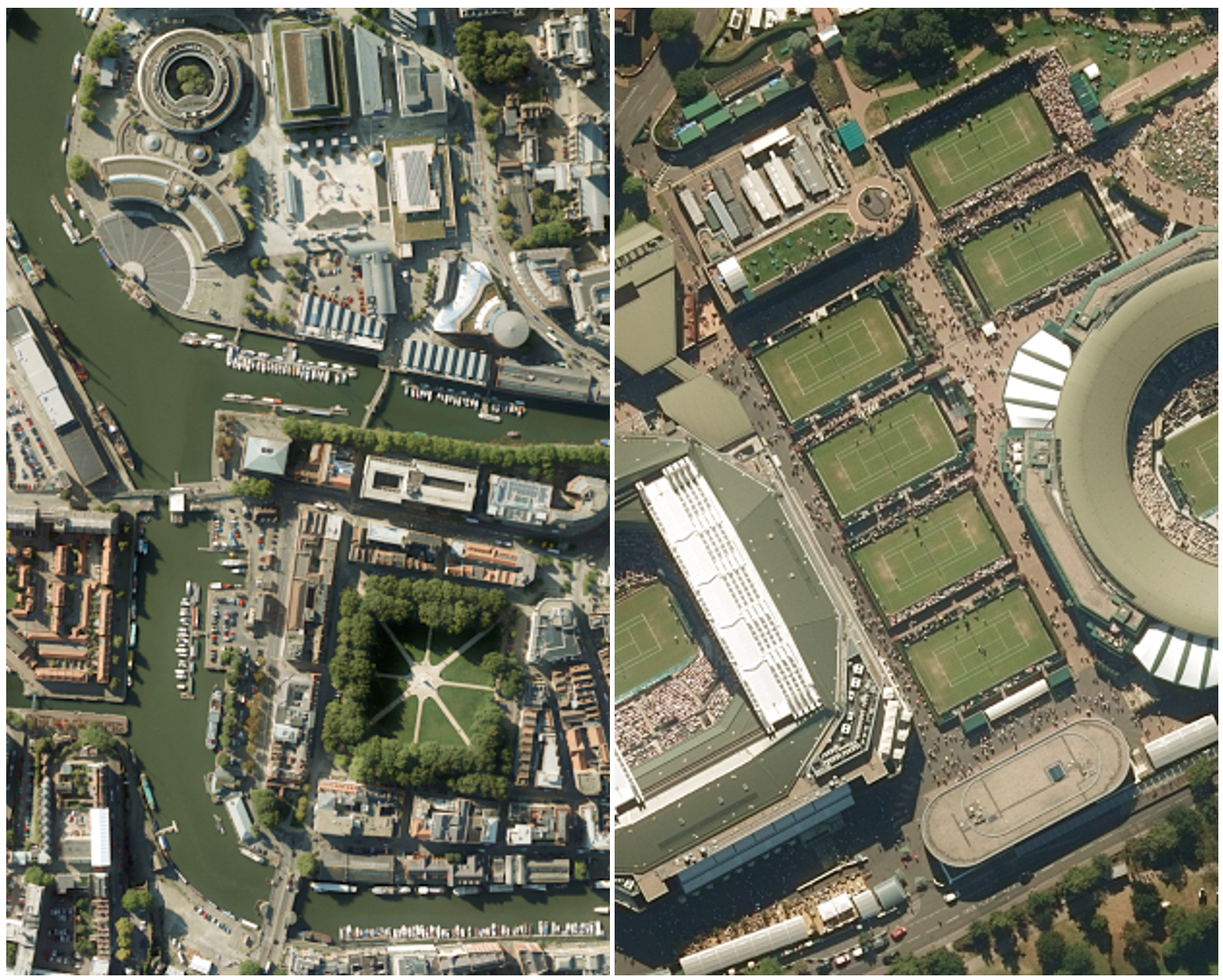 A 25 cm resolution RGB image of Bristol depicted on the left with a 12.5 cm resolution RGB image of Wimbledon depicted on the right.
Hexagon Geosystems
Hexagon Geosystems’ HxGN Content Program is the largest aerial library of high-accuracy airborne data.
Their orthophotos, digital surface models, and stereo imagery coverage spans across the US and much of Europe.
Hexagon's aerial data accuracy is regularly refined. Currently, imagery is 30 cm resolution in wide areas, 15 cm resolution in urban areas, and 15 m in both wide and urban areas. Each dataset is ortho-rectified, accurate, and cloud-free.
Hexagon’s aerial imagery is provided as a streaming service on a yearly subscription model. Their coverage map makes it easy to know if imagery is available over your area of interest. You can access Hexagon aerial data on UP42.
Nearmap
Based in Australia, Nearmap offers high-resolution aerial imagery with coverage across the United States. They offer vertical, oblique, as well as 3D and AI project mapping capabilities.
With both historical archive and regularly refreshed imagery, Nearmap enables detailed change analysis to be conducted, adding time as a critical fourth dimension.
As described on their website, “annual subscriptions cover current, future, and historical imagery across 430 urban areas, including the cities and suburbs that house over 71% of the US population—surveying 330,000+ square miles each year.”
OpenAerialMap
OpenAerialMap brings together tools for searching, sharing, and using openly licensed satellite and unmanned aerial vehicle (UAV) imagery.
It is an open service that is built on top of the Open Imagery Network (OIN), and is made available through the Humanitarian OpenStreetMap Team’s OIN node.
The OpenAerialMap Browser is a simple way to browse and obtain available imagery. Everyone who would like to get started with using aerial imagery—from pilots studying areas in crisis to mappers tracing local regions—can do so through the community database.
Vexcel Imaging
With over two decades of photogrammetry and remote sensing experience, Vexcel Imaging offers digital aerial cameras and mobile mapping platforms.
Their UltraCam line of products offers a sensor portfolio covering aerial, ground-level, and even indoor perspectives. Solutions range from wide-area and high-altitude mapping, nadir and oblique capture, as well as short time, large area capabilities.
Combined with their processing software, UltraMap, Vexcel Imaging enables point clouds, ortho imagery, 3D capabilities, and more. Vexcel is also available on UP42.
Using aerial imagery
One of the most significant advantages of aerial imagery is its ability to integrate as a base layer into GIS, CAD, and other applications to work with it at scale.
That’s why aerial imagery providers like the ones we’ve just mentioned often provide web-based platforms allowing you to measure, annotate, and save edits in one place.
For example, NearMap imagery can be accessed straight from the Esri and Autodesk interfaces and used to create 2D and 3D models.
Applications of aerial imagery
Aerial imagery is an indispensable tool for topographical mapping and the interpretation of places, objects, and features.
The remote sensing method collects vital information that can be used for land use, agricultural management, forestry, conservation, urban planning and more.
Aerial for disaster management
When disaster strikes, it is crucial for relief workers, community leaders, and stakeholders to gain an understanding of what has changed and how.
With aerial imagery, especially using drones, this situational awareness can be the difference between life and death.
Drones are estimated to save one life a week. In late 2015 in India, up to 200 people were rescued from severe flooding as a result of drone use—which helped to narrow the search grid for rescue teams to tailor their search for survivors.

Aerial for precision agriculture
Agritech is a growing industry, as farmers across the world use remote sensing data to make informed decisions, maximize crop yields, and reduce waste.
Aerial imagery in multiple wavelengths allows growers to plan scouting, management, and interventions.
Using multispectral sensors and normalized difference vegetation index (NDVI), plant health can be determined and as a result, addressed.
For more information on NDVI and how to use it, here are 5 Things to Know About NDVI.
Aerial for asset monitoring
Traditional methods of asset inspection require time-consuming and expensive logistics. The use of aerial imagery has enabled accessible remote asset monitoring.
From public utilities to private facilities, high-resolution aerial imagery optimizes infrastructure management, while closely monitoring assets over time.
This way, maintaining equipment and infrastructure can be done proactively and preemptively. As a result, saving resources in the long run.
Aerial for habitat protection
Aerial imagery provides dynamic information on global environmental indicators related to habitat loss and climate change.
Ideal for zooming in on regional areas, aerial photographs of land allow us to better identify and mitigate changes over time.
For example, as temperatures continue to rise, many species of fish such as salmonids in Alaska (below) struggle to survive. Being able to identify areas within a stream which are persistently colder than surrounding areas, will be critical to their survival.
Scientists have begun mapping these cold water habitats. This is valuable to protect and restore critical fish habitats and direct monitoring efforts as warming waters continue.
Thermal infrared imagery provides us with another perspective, beyond what the eye can see. Combined with ground-truthing data, aerial imagery applied in this way provides us with the perspective we need to gain, in order to solve the biggest problems of our time.
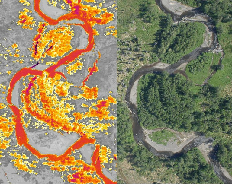 Thermal infrared (left) and color imagery (right) of the Anchor River (orange) in Alaska revealing cold water inputs (purple) in a project to map fish-safe cold-water habitats, away from warming waters. (Cook Inletkeeper/Watershed Sciences, Icn)
Summary
Aerial imagery refers to all imagery taken from airborne craft. It is categorized according to camera axis, scale, and sensor.
While satellite images have greater large-scale scientific applications, aerial photography has greater small-scale commercial applications.
There are many aerial imagery providers that capture their own aerial imagery, or distribute on behalf of others in their database.
The remote sensing method collects vital information that can be used for land use, agricultural management, forestry, conservation, urban planning and more.
Capturing the world from above is useful for both regional analysis, as well as zooming in on specific areas. Aerial photographs are snapshots in time, providing us with historical perspectives on how landscapes used to be and how they look today.
Using aerial imagery, we are able to explore connections between elements of landscapes that can be difficult to perceive from the ground. Flying closer to the ground than satellites, aerial imagery provides us with a detailed and high-resolution view from above—revealing otherwise unseen features.
Ready to use aerial imagery? Sign up to UP42 and access aerial imagery today.


