


Welcome to this first ever update that’s also an end-of-year retrospective! Each month, we've shared the product updates that matter most to you. It's an end of an era as we're moving from these long-form blog posts to newsletter-style emails, so make sure to subscribe to those to get the latest! This time around, we’ll still update you on what’s happened this past month, but also will look back at 2021’s Top Hits for UP42. It’s been a blockbuster year with lots of buzz about all the great things still to come for 2022, so let’s dive into it!! 👇
——— ✨ What's New on UP42? 🚀 ———
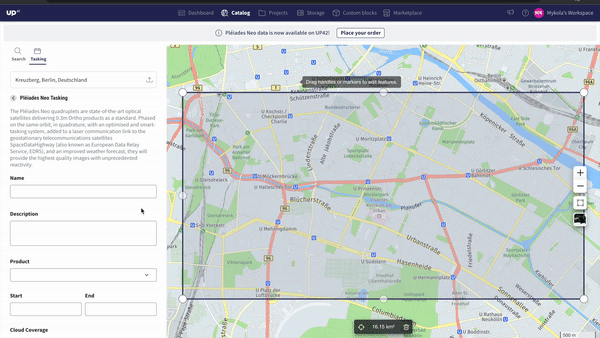
Tasking like never before 🔍
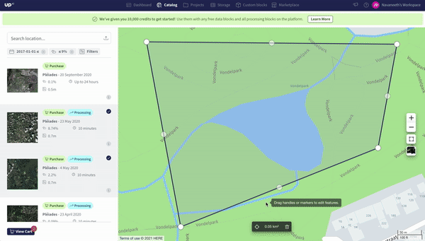
Tasking can be a complex process with lots of back-and-forth, often requested and delivered via email. Gone are the days of being restricted to scouring through your email inbox to see if you sent in that tasking request or if your data has arrived yet. Customers now have the ability to choose and order data from the different archives of our providers or schedule a tasking request all in the same route on different tabs, making the Catalog a one-stop-shop for all things data related.
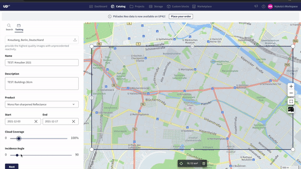
The steps to place your order from the UI are straightforward. Simply navigate to the tasking panel from Catalog Search, select the constellation you'd like to task, add in your necessary information, like imaging window, product name, and cloud cover %, and then submit your request.
Once the order is placed, it would be visible on the Orders page of the console, under tasking and of course through the new Tasking API.
Here are some helpful links to get you started:
Read about this update and more in our release notes.
Shiny new SDK version 💻
If you haven’t already used the UP42 python SDK, today’s a great day to start as we’ve released SDK version 0.18.0, which entails significant speed & usability improvements when handling large orders, assets, jobs and more. Some of the advantages you’ll enjoy include:
- Ability to add sorting criteria
- Results pagination to avoid timeout issues when querying large asset/order collections
- Significant speed improvements
See the full changelog here and delve deeper into how this update facilitates your processes.
——— 💫 Let's Get Retrospective 🕺 ———
What’s launched this year 🚀
For the quick overview, watch this video below:
50+ new satellites 🤯
We’ve added over FIFTY new satellites from our partners this year, and that’s just the ones we’ve announced! This litany of new satellites range from high-resolution SAR to hyperspectral to night-vision, unlocking new use-cases like Infrastructure Change Monitoring, Disaster Response, Height Identification, & Geological Applications.

All of these 50+ new satellites have come from new partnerships like that with Head Aerospace, as shown above, and SIIS, as shown below, as well as from existing partners, such as the case with Pléiades Neo from Airbus.

Last month, we announced the availability of very high-resolution optical imagery from the Airbus Pléiades Neo constellation. Two satellites were launched in 2021 with another two slated for 2022. Pléiades Neo’s unique combination of 30cm native spatial resolution, frequent revisit, new bands like Red Edge and Deep Blue, and faster tasking/data delivery make this dataset a powerful resource for any savvy geospatial analyst.

The uniqueness of these new satellites is not the only advantage, but also more satellites means greater likelihood of there being an image of your area when you need it.
Double Data for Pléiades & SPOT w/ Archived Storage 📈
Archived Storage-- if you haven’t heard of it before, it’s much more crucial than the name might imply. By activating access to OneAtlas's Archived Storage, we roughly doubled the number of high-resolution satellite images available to you from these datasets. The gif below showcases how you can now choose between 2.7 times more scenes in the US than were previously available.

The advantage is clearly visible from the Catalog as well. This data is delivered within 24 hours, a timeframe which is indicated within the search results, allowing you to prioritize latency if and when required.
Purchase with Confidence 💪
We understand that knowing the estimated price ahead of time and knowing how long it may take to acquire data can be vital to winning projects with your clients. Now directly from the Catalog search, you can clearly see both a price estimation and a data delivery time estimation as well as all the other key specs you may want to consider before purchasing.

This estimate is available both within the console or through the Python SDK, leveraging the command, workflow.estimate_job(input_parameters).
Beyond that, you may have read in our last update that we’ve also employed credit holds and real-time updates on credit consumption. And as if that wasn’t enough, because we’ve now enabled teams with UP42, you can have full visibility of your companies processes and the credits you have on a company scale. Now, you can get up-to-date visibility into your ordering patterns and credit consumption directly from the dashboard.
The combination of price estimation and data delivery time estimation directly from the Catalog, dashboard redesign, credit holds, and real-time updates on credit consumption, decision-makers have all the purchasing transparency to meet their project requirements.
Check out the new dashboard here.
Better, More Intuitive Experience ⚡
We’ve added significant updates to our platform and overall console experience such as in-app guidance, HERE Maps integration for more advanced geocoding, and pre-configured workflows to help you, our customers.
With the preconfigured workflows for example, you can bypass all the effort of reading product descriptions and documentation to set your parameters and ensure you have a workflow to test out that yields good results. See the flow below.
What all of this means for you is that you and your team can get started faster on accessing the right data and building their own solutions. See it to believe it here.
Countless New Datasets and Algorithms 📦
Ok, that title is not entirely true. You can easily count up what we have on our platform to date, which is an astonishing 85 Algorithms and 63 Datasets.

——— 📅 Stay Tuned for More ———
What can you expect in 2022? 🎆
Another revolution around the sun, another revolution in the geospatial industry to come. This year has brought its challenges and countless opportunities. So much has happened in fact that there were even some new partners with trailblazing datasets and solutions that we just didn’t have time to announce! So keep an eye out for that.
One trend we’ve seen is resounding success for our customers that know the importance of gathering insights at scale via the UP42 API, integrating us into their solutions. We expect more of this trend in the new year and more content around this topic.
For now, make sure to sign up here to you can get access to 10k free credits to get started with UP42 and more importantly, so you don’t miss out on what’s to come in 2022.
That's all, folks! Thanks for reading and I hope you enjoyed unwrapping all of these feature-shaped presents just before Christmas. 🎁 Make sure to keep an eye on our Release Notes and I look forward to seeing you back here in the new year! 🎉


