ASTERRA: Earth observation that sees below the surface

UP42’s partner ecosystem is crucial in helping us achieve our goal of simplified access to Earth observation insights. So, we’re excited to announce our new partnership with ASTERRA, specialists in extracting soil moisture information from satellite data.
Who is ASTERRA?
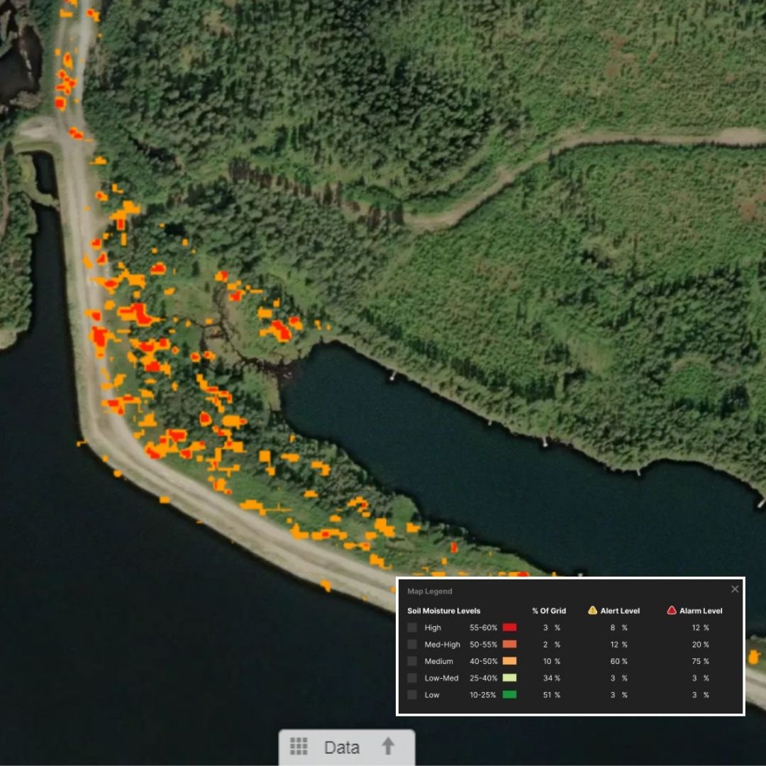
ASTERRA provides subsurface soil moisture insights for many sectors, including water utilities, agriculture, government agencies, and infrastructure companies. They leverage SAR data, patented algorithms, and artificial intelligence to detect leaks, assess pipes, and locate moisture near major installations.
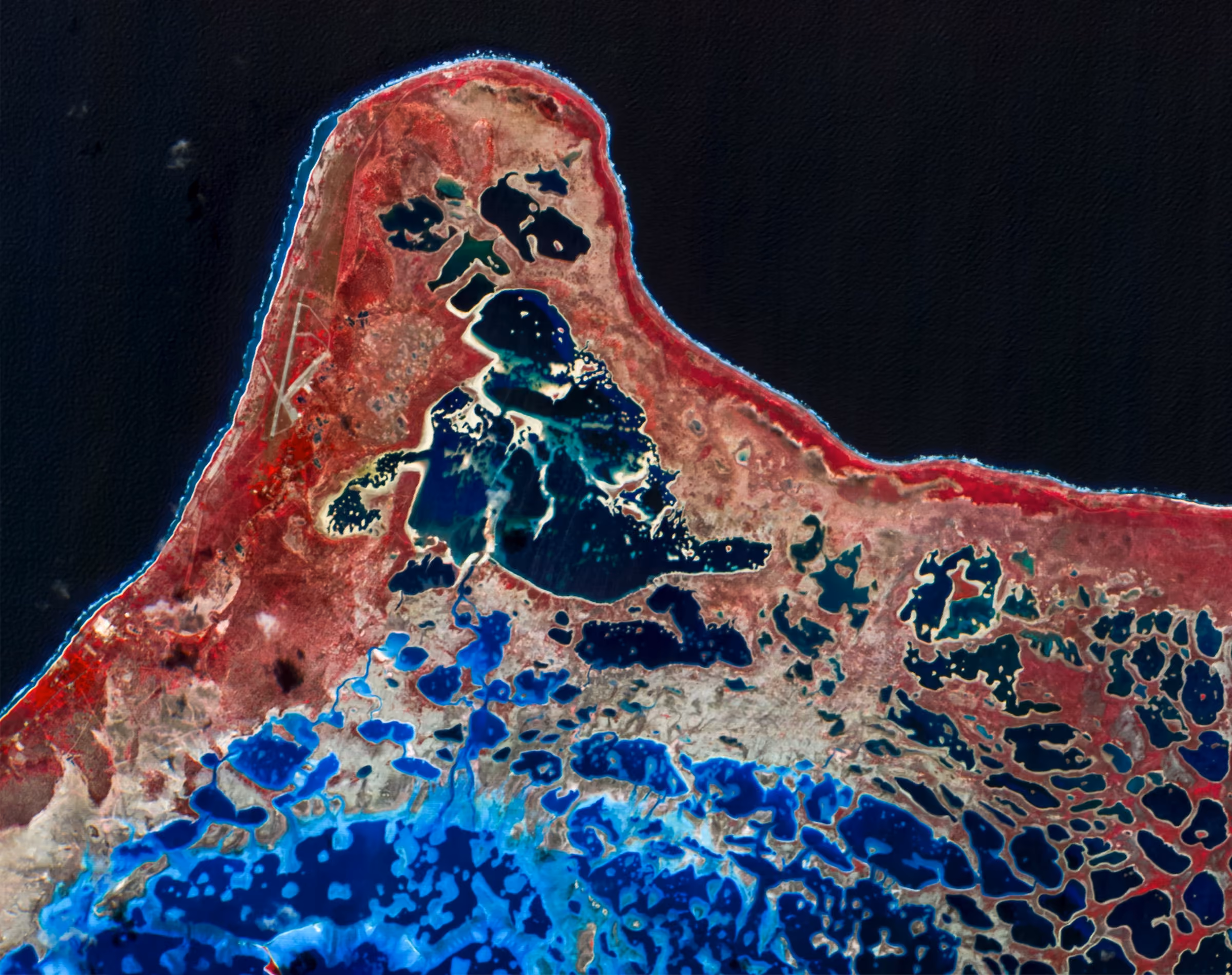
What sets ASTERRA apart is their application of L-Band SAR data. Like with all SAR data, the collection of L-Band SAR is possible regardless of weather conditions, day and night. SAR images from L-band satellites have longer wavelengths compared to C- and X-bands, making them more coherent over time, especially in areas with heavy vegetation. Wavelengths determine how the radar wave interacts with the surface, and how deep it can penetrate. X-band SAR has a wavelength of about 3 cm—which means it will most likely interact with the leaves of the trees only. An L-band signal has a wavelength of about 23 cm, so can achieve deeper penetration. In addition to vegetation, the L-band can penetrate soil, ice, and even infrastructure to provide subsurface information that isn’t possible with other remote sensing technologies.
Why is soil moisture content important and how can we measure it?
Soil moisture refers to the water held in the spaces between soil particles. Its significance varies across industries and applications, but measuring soil moisture is crucial for several reasons, including climate monitoring, soil erosion prevention, water quality management, early drought warnings, and more. Accurate soil moisture data enhances weather forecasting, improves risk assessments, and supports better decision-making across these diverse fields.
Despite the importance of soil moisture information, continuous measurement methods are lacking. Two main techniques are currently used to measure soil moisture. In the first, soil samples are tested to determine the gravimetric water content (GWC). While this method is precise, it’s also labor-intensive. The soil needs to be brought to a lab, weighed, heated to 105 °C, dried, and then re-weighted: the difference in mass shows the water that has evaporated.
The direct field test method involves a technician using a time-domain reflectometry (TDR) meter. This method is also precise, but requires expensive equipment and has limitations, especially when soil has a high salt or clay content. It monitors the time needed for an electromagnetic signal to pass through a steel sensor in the soil and reflect back. The speed of the feedback signal is influenced by the soil’s water content.
Both methods use ground crews, examine moisture from a precise sample, have a restrictive date range, and don’t allow for in-depth measurement of wide areas. In contrast, using SAR data can enable monitoring of a wide area, regardless of how remote and inaccessible the location might be. This method can also complement additional topographical, drainage, and geotechnical information, and help identify specific risks to guide further inspection, thus optimizing resources.
What are some example use cases?
Satellite-based soil moisture mapping plays an important role in many industries.
- Agriculture: optimizing irrigation strategies, ensuring optimal water distribution, and fostering resource-efficient agricultural practices.
- Construction: proactively managing foundation stability risks to ensure structural integrity, and fostering safer and more resilient construction practices.
- Disaster management: offering pre and post-analysis for infrastructure assets, such as dams and levees, providing early warnings and enhancing overall flood preparedness and response efforts.
- Energy: offering a comprehensive evaluation of soil conditions around pylons, making energy infrastructure more resilient, and maintaining stable foundations to ensure the safety of energy transmission networks.
- Environmental: supporting comprehensive monitoring and ground assessments, and helping environmental professionals manage ecosystems, water resources, and overall environmental health.
- Infrastructure: preventing failures and enhancing overall resilience, preemptively addressing potential risks, optimizing maintenance strategies, and ensuring the longevity of critical structures.
- Insurance: assessing property and infrastructure risks, leveraging post-disaster insights to facilitate efficient claims management, mitigating damages, and improving risk modeling and response strategies.
- Mining: ensuring the stability of tailings dams by evaluating subsurface moisture levels, empowering mining professionals to prevent failures, and promoting safe and responsible dam management.
- Real estate: identifying real estate plot vulnerabilities, and optimizing property development to enable informed decision-making for buyers, investors, and real estate professionals.
- Transportation: mitigating sinkhole risks by providing early indications of ground instability along road networks, as well as allowing for timely maintenance and intervention to ensure safety and prevent disruptions.
- Urban planning: optimizing pipeline infrastructure and drainage assessments by highlighting areas prone to debris accumulation and flooding risks, enhancing drainage systems, and strategically planning pipeline networks, ensuring the resilience of urban areas against environmental challenges.
ASTERRA has developed a unique technology for subsurface soil moisture mapping that can cover thousands of square kilometers at once, without any sensors or devices on the ground. This allows for early problem identification and cost savings. To find out more about ASTERRA and how you can order the data on UP42, visit our marketplace.

Subscribe to our newsletter
Stay up to date and learn about our fast-growing new features
