


The geospatial industry has exploded over the past few years and with it, so have data volumes. As more and more players popped up, the industry faced a challenge: how could they simplify data management for providers, developers, and users?
The answer to this question is STAC, which we’ve now integrated with the UP42 platform. In this article, we’ll tell you about our new storage capabilities with STAC, and explain STAC in a nutshell to show you how you’ll benefit from it.
What is STAC?
STAC (SpatioTemporal Asset Catalog) provides a universal standard and common language to describe geospatial information. If you’re new to STAC, it might seem like just another data standard at first. But STAC goes beyond this. It was first introduced in 2021 and has only improved and grown in popularity since then. Many of the biggest providers of remote sensing and spatiotemporal data use the STAC specification. And with more and more geospatial collections made publicly available, you have a great way to learn STAC.
STAC allows users to easily search for, acquire, and analyze geospatial data from multiple providers and sources. This is extremely important because a lack of standardization often leads to low availability of plug-and-play integrations. If you want to build a robust backend and easily explore data from different providers, STAC can give you the foundation.
Some of the main benefits of STAC include:
- It has a well-designed, standard format
- It is user-centric
- It’s openly searchable and discoverable
- It’s crawlable and indexable
- It has a simple, extensible core
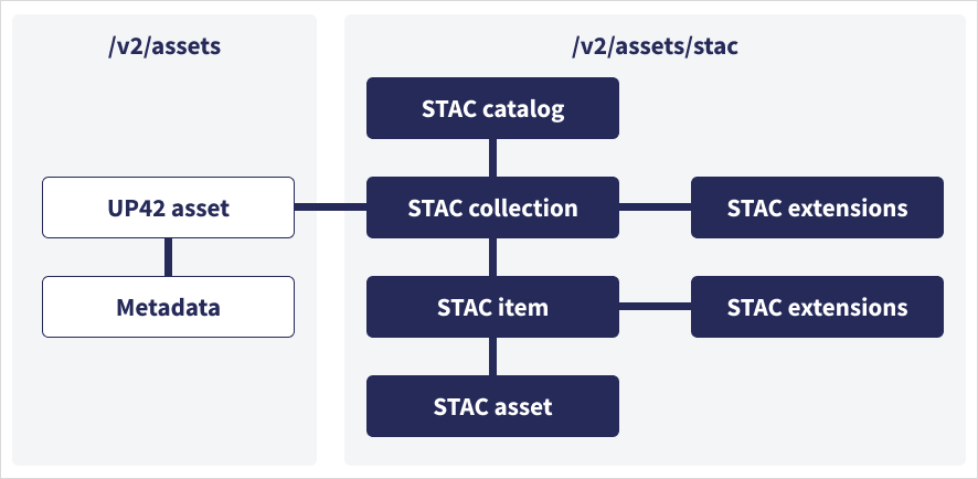
STAC is a specification containing information about your geospatial asset. It’s organized in a structure of catalogs → sub catalogs → collections → items. A STAC catalog provides a flexible structure to link STAC items together so they can be crawled or browsed. It contains a list of STAC items and a list of child STAC catalogs. A STAC collection provides additional information about a spatiotemporal collection of data such as license, keywords, providers, and more, and can be easily extended for additional collection-level metadata. A STAC item is a GeoJSON feature representing a collection of inseparable data and metadata, metadata being the complete depiction of your data. You can read more about it here.
Existing STAC initiatives at UP42
UP42 adopted STAC in 2022 for searching and ordering geospatial data on our platform, without strictly integrating the STAC specification. The UP42 API queries data sources based on the STAC specification. We implemented a unification layer, transforming data from STAC-compliant providers, as well as any other standards. This is important, as very few data sources provide STAC-compatible search APIs. Below is an example of how different companies describe the same entity that was compiled by our Senior Backend Engineer Valeriia Zakhlieniuk and presented at the Cloud-Native Geospatial Outreach Event in April 2022.
| Area of interest | Date | Item ID | Collections | |
|---|---|---|---|---|
| Examples | geometry location bound aoi aoiInGeoJson |
validtime dateRanges startDate endDate start_datetime |
uid strip_id parentIdentifier sourceIdentifier |
item_types sensor datasetName platforms missionName |
| With STAC | bbox intersects |
datetime |
id |
collections |
After introducing STAC for ordering data, we’re now adopting the STAC specification for your stored data too, bringing consistency across the UP42 platform and value chain.
Bringing STAC to UP42 storage
We now provide a STAC API endpoint for data searches in UP42 storage. UP42 will extract the metadata for all your geospatial assets from existing user storage and make them searchable through our STAC asset service. This ensures a consistent metadata format across all providers, as well as a minimum of geospatial information, such as ID (e.g., asset, order), geometry, bbox, datetime, or href, always available for assets in storage. The assets can be data from catalog or tasking orders. With one standardized metadata format, you can now easily integrate data into your pipeline. Let’s look at a tasking example. You’ll automatically get the respective metadata for your tasked assets in the API shortly after the raw asset is delivered into storage, so you can immediately work with it based on your STAC-defined workflows and API calls.
The UP42 storage component is a STAC catalog, in which each UP42 asset is represented with a collection, following items and assets. Each user has, therefore, full access to the STAC item search capabilities for the assets to which they have access. UP42 has also introduced relevant STAC extensions for the respective kind of geospatial asset (e.g., EO, Projection).
In addition to introducing STAC, we have also redesigned our storage and created a new set of functionalities. For you, this means that you can manage your assets and update their metadata, as well as download your assets. List all your assets and their metadata to get an easy overview of current assets in your workspace, sort and filter them, as well as search by the sensor, provider, name, date, AOI and more.
| Current challenges | Impact with new storage |
|---|---|
| No consistent metadata standard across providers | STAC-compatible endpoints for all geospatial assets |
| Inability to manage data in your organization | Reflect your internal asset structure by customizing assets with your own title and tags |
| Inability to find assets easily | Search for a specific asset property (e.g., order ID, title, or asset name) or create a consolidated view of your assets through sort and filter operations for collection, producer, tags, title, and source |
| Inability to work across workspaces of different users | Get an asset overview of your whole organization by running search and filter operations on the workspace and account level |
And the best part? Storage remains free of charge to you.

Read more about the new STAC asset service in our technical documentation.
This is another step to strengthen our commitment to the STAC standard. With more and more companies embracing STAC, we believe the ecosystem will continue to grow, and we want to play a key role in supporting our partners and customers throughout their journey. If you’re already wondering what’s next after making our storage STAC compatible, we have an answer: more cloud-native geospatial data formats and their implementation. Next up, a standard archive format that will transform raster data into standardized COGs, exposed through STAC. With this functionality in place, you’ll be able to stream your data on demand and get only the parts you need, instead of streaming the bulk of it. Expect more updates from us soon.


