Leveraging SAR and elevation data to assess the potential scale of flood damage

Flooding events are growing in severity around the world. In 2023 alone, floods caused thousands of deaths and 14 billion USD in insured losses, according to SwissRe. Germany, where UP42 is based, is currently experiencing a deadly flooding crisis along the Danube and its tributaries in the southern states of Bavaria and Baden-Württemberg.
As authorities and insurers rush to respond to the crisis, satellite and geospatial data play a key role in informing these parties about the potential scale of the damage. Here, UP42’s platform can assist these users in getting the multi-modal data they need to best make decisions during key response periods.
Seeing through dark clouds
While most people associate geospatial data with optical color images similar to those taken by our cameras and phones, this data is not well-suited for monitoring floods. Given flooding is usually associated with cloudy periods of high precipitation, optical remote sensing satellites are blocked from taking useful imagery. Here, an alternative imagery source can play an important role: Synthetic Aperture Radar (SAR).
SAR satellites can see through clouds, and easily detect surface water, making them ideal for monitoring flood events, even as the disaster is unfolding. An example of this kind of imagery taken from the ESA’s Sentinel-1 satellite can be seen below.
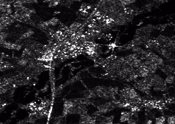
This image shows VV-polarized backscatter over the town of Petershausen in Bavaria on June 2nd, hours after flooding hit the area. While difficult to see in the SAR image, the data contained within the pixels enable remote sensing professionals to extract areas of flooding using index-based methods or machine learning, and then overlay them on earlier optical imagery of the area (see below).

The UP42 platform and API enables users to rapidly task high-resolution SAR providers from multiple providers and constellations, including Umbra, ICEYE, Capella Space, KOMPSAT-5, and TerraSAR-X. This wide range of data sources enables users to quickly find a sensor and an acquisition mode which best suits their particular needs. Moreover, the large number of providers increases the chances that a satellite will be available in the short time frame needed to respond to an emergency.
Knowing the lay of the land
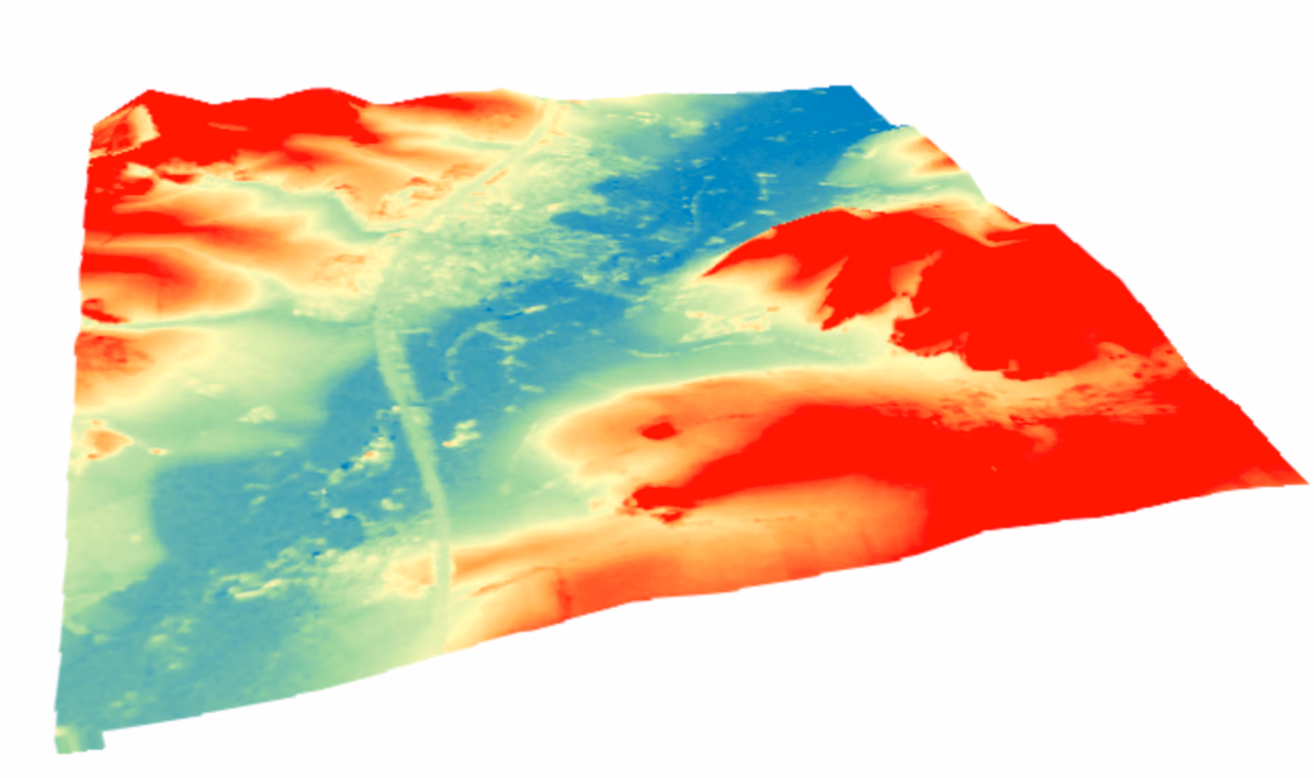
While having access to SAR data is a boon for those involved in emergency response and insurance claims, it can be further augmented by another source: Digital Elevation Models (DEMs). These models provide detailed elevation data about an area, either just the topography of the land in the case of Digital Terrain Models (DTMs), or the land and everything on it, including houses, trees, and other features in the case of Digital Surface Models (DSMs). In the case of flooding, this data can be extremely useful in determining which areas could potentially have been affected by flooding, or indeed work out the height of the flooding above the normal river level. Below we can see an Airbus WorldDEM Neo DSM raster obtained via the UP42 platform covering the same area (Petershausen, Bavaria) as the Sentinel-1 image.
The UP42 platform offers numerous DEM data sources within our catalog, including collections from Airbus, Hexagon, NEXTMap, and Vexcel Elevate. These collections, which cover large fractions of the world, enable users of the UP42 platform to choose the best DEM data for their use case, with resolutions ranging from 10 m per pixel, all the way up to 30 cm per pixel.
The usefulness of integrating this kind of data together with SAR imagery lies in the way that it can be used to determine more precisely, the possible extent of a given flood. Below we can see how the SAR-based water detection can be combined with the elevation data to ascertain the flooding height and then generate a better picture of where the flood may have reached. Furthermore, OpenStreetMap data on building footprints can also be added into the mix, to provide an even better picture of potentially impacted structures, something that is incredibly useful for insurancers looking to quickly estimate potential claims and payouts from a given flooding disaster.
With the number of catastrophic flooding events only set to rise into the future due to climate change, satellite and geospatial data will serve as a key tool to understand, monitor, and mitigate the effects of these disasters. UP42 stands ready to provide the wide range of data sources needed for in-depth analysis, and help connect key sectors with the products they need in a rapid and accessible manner.


Subscribe to our newsletter
Stay up to date and learn about our fast-growing new features
