Processing levels on the UP42 platform, explained

Geospatial imagery is a critical tool for plenty of use cases, from urban planning to environmental monitoring. However, raw data captured by satellites, drones, and aerial sensors needs processing before it becomes actionable. This is where geospatial imagery processing levels come into play. Each level of processing—from raw, unprocessed data to thoroughly processed and interpreted imagery—plays a crucial role in enhancing accuracy, usability, and actionable insights. Understanding these levels is critical to ensuring that the data we rely on is not only accurate but also fit for its intended purpose.
The UP42 platform allows you to choose between two primary processing levels: geometric and radiometric. We map all our optical imagery on the same scale, allowing for clear comparisons and for you to make the best choice for your use case.
Geometric processing
Geometric processing levels are a critical step in ensuring the spatial accuracy of geospatial imagery. Raw images often contain distortions caused by factors like the sensor's angle, the Earth's curvature, and differences in terrain elevation. Geometric correction aligns imagery with real-world coordinates, ensuring that features are accurately mapped. This precision is vital for applications like urban planning, disaster response, and navigation, where even minor distortions can lead to huge problems.
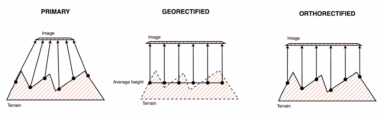
Primary
Primary imagery is the rawest form of optical imagery. Besides some corrections to account for optical and sensor aberrations, this imagery is the closest to what is captured by the sensor. Primary imagery allows users to perform orthorectification or elevation model generation from stereo pairs.
It’s best suited for users that have their own pre-processing workflows.
Georectified
Georectified imagery is aligned with a coordinate reference system. It assumes an average terrain height for a given area and projects each point of the captured imagery to this surface.
This means georectified imagery is ready to be used in GIS platforms alongside other georeferenced imagery.
It’s best suited for users who want plug-and-play imagery for their processing workflows.
Orthorectified
Orthorectified imagery is aligned with a coordinate reference system while accounting for distortions introduced by camera angle and terrain. This process is more computationally intensive, but the resulting imagery is more precise and geospatially accurate, allowing it to be used for mapping, analysis, and detection.
It’s best suited for geospatial librarians who rely on multiple imagery sources.
Radiometric processing
Radiometric processing adjusts pixel values to account for variations in lighting conditions, atmospheric interference, and sensor inconsistencies. Radiometric correction adjusts pixel values so that light intensity, brightness, and contrast are closer to surface characteristics. This step is crucial for applications such as environmental monitoring, agriculture, and resource management, where precise data on surface conditions is necessary for accurate analysis.
Basic
Basic imagery is provided as raw pixel values or digital numbers (DN) with some sensor-specific corrections. This imagery represents what is captured by a given sensor, allowing users to apply their radiometric calibration workflows.
It provides close-to-raw data that can be used for custom radiometric calibrations and is ideal for scientific analysis or algorithm development.
TOA
Top-of-atmosphere imagery converts the pixel values to natural values, like the radiance or reflectance seen at the height of the sensor.
It can be used for atmospheric analysis, climate study, and to provide some insights into ground conditions.
Surface reflectance
Surface reflectance or bottom-of-atmosphere imagery has undergone radiometric conversion and atmospheric correction to provide values closer to the natural or actual values seen on the Earth’s surface. You will see clouds and other atmospheric aerosols, but all systemic atmospheric effects will be eliminated.
It provides surface reflectance imagery for assessing land conditions without atmospheric interference, perfect for environmental monitoring or vegetation health analysis.
Display
Display imagery is color-corrected to provide imagery with natural or true colors, as seen by the human eye. It won’t represent meaningful physical values, but it will be visually meaningful and appealing, allowing you to use it directly for visualization, communication, and image detection algorithms.
It provides visually interpretable imagery with natural colors, making it suitable for communication, presentations, or quick visual assessments of landscapes.
Bit depth per pixel
Bit depth or dynamic range represents the number of bits used to represent each pixel in an image. The bit depth of imagery can influence the image detail and quality and what you can do with it.
8-bit: This bit depth is used for more processed imagery with a smaller dynamic range. This is great for visualizing imagery, as the color value range better represents how humans perceive them. It’s directly compatible with all displays and is suited for visualization and feature detection in imagery.
16-bit: This bit depth is used for more raw imagery and has a greater dynamic range of values. This is great for classification and more in-depth analysis.
Combinations
Different combinations of processing levels can be used for different use cases as can be applied. Some of our more popular imagery uses the following combinations.
Vexcel provides 8-bit imagery with orthorectified geometry and display-level radiometric processing.
Pleiades Neo can offer primary surface reflectance imagery in a 16-bit format.
SkySat imagery is orthorectified and can be delivered as 16-bit surface reflectance data.
Learn more
UP42 lists all these specifications all the time, consistently, and across all our offerings. Whatever your needs are, and wherever in the chain your needs lie, we have imagery to serve your needs.
We don't just provide imagery; We give you the tools and information to make the best decision for your use case all the time and unlock the potential of geospatial imagery.
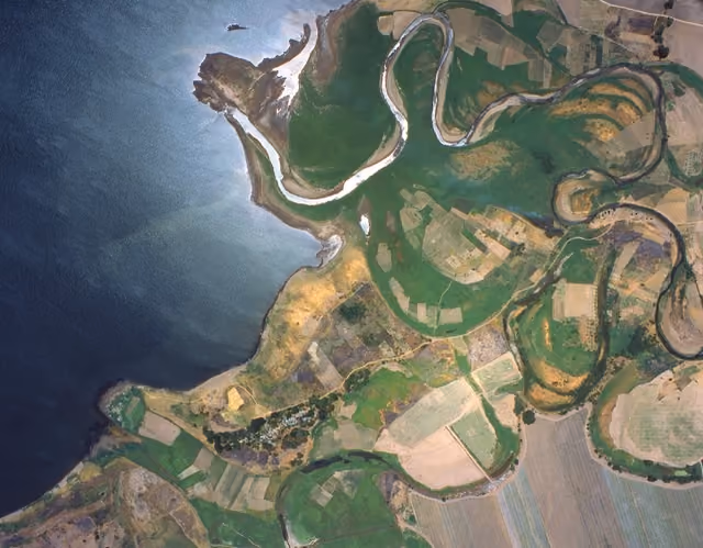
Find the above sample data and more on our console.

Subscribe to our newsletter
Stay up to date and learn about our fast-growing new features
