See more from above with Getmapping aerial imagery
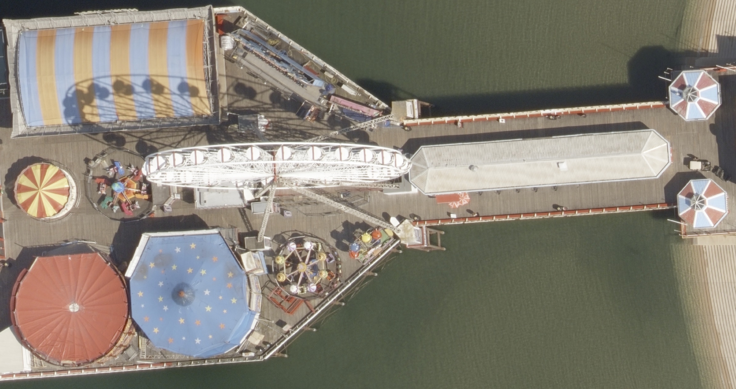
Getmapping provides aerial imagery at very high levels of detail and accuracy, and enables the engineering and construction markets to visualize and analyze their chosen AOIs. The new Getmapping 5 cm CityView flying program gives a unique perspective on urban areas, covering all major towns and cities in the UK and Ireland.
The world looks completely different from above. When looking down at Earth, we see details that aren’t apparent at ground level. Landforms and objects such as buildings, bridges, and trees have additional spatial attributes which can only be captured from the air. And thanks to modern aerial imaging, it’s easier than ever to create a bird's-eye view of our planet.
Our partner, Getmapping, is keenly aware of the power of aerial imagery. And their ultra high resolution data is now available on UP42.
Aerial imagery meets the high expectations of the engineering and construction markets
Highly accurate geospatial data is particularly valuable in the engineering and construction markets, where new technology-driven solutions increasingly rely on the availability and accuracy of spatial datasets. With good data, users can depict reality in its current state and transform plans into digital representations.
Here are some key areas where aerial imagery brings significant benefits:
- Site analysis and planning: Aerial imagery provides a comprehensive view of a construction site or potential project area. It can be used to assess the terrain, existing structures, vegetation, and other relevant features.
- Surveying and mapping: Aerial imagery, equipped with photogrammetry capabilities, can be used for precise land surveying, mapping, and even creating 3D models.
- Design visualization: Aerial imagery provides a unique perspective for architects and designers. Professionals can visualize the project in its real-world context, which helps to understand the relationship between the proposed structure and its surroundings.
- Construction monitoring: Aerial imagery can be used to monitor progress, track changes, and identify potential issues. Regularly capturing a construction site, for example, allows project managers to compare actual progress, detect discrepancies, and improve safety on-site.
- Infrastructure inspection: Aerial imagery is invaluable as a tool for inspecting large-scale infrastructure projects such as bridges, highways, and pipelines. This helps in the early detection of issues, improving safety, and reducing the cost and effort required for manual inspections.
Let's have a closer look at Getmapping aerial imagery and the values it brings
Having established some of the challenges and opportunities faced by the engineering and construction market, and how they can be addressed by leveraging the power of aerial imagery, we’ll now introduce a company that provides these geospatial products and meets the high expectations of the market.
Getmapping is a British company that specializes in geospatial surveys, data, and solutions, with a 25-year experience in the capture and delivery of high-resolution aerial imagery, LiDAR, and digital mapping. They believe that everyone can benefit from easy access to location-based intelligence, and their mission is to transform geospatial data into actionable insights and visuals to enable better decision-making.
As the first company to collect nationwide aerial photography of Great Britain in 1999, and the only company to have continuously maintained the imagery layer ever since, Getmapping is an expert in aerial imagery.
Aerial imagery delivers value across a range of different sectors, including architecture, engineering, and construction. Furthermore, switching to a digital representation of the built environment reduces the need for onsite visits, reduces travel time and costs, increases productivity, and helps deliver carbon reduction plans.
Getmapping captures high-resolution vertical aerial imagery at different resolution levels, including:
- NationalView: 12.5 and 25 cm resolution imagery, available for the whole of the UK and Ireland. NationalView data is updated on a 3-year cycle – so the data will never be older than 3 years – with archive data available dating back to 1999.
- CityView: a new flying program that for the first time captures aerial imagery of all the major towns and cities in the UK and Ireland, at ultra high resolution (5 cm). In addition, CityView data is updated annually, providing the most detailed imagery content on the market.
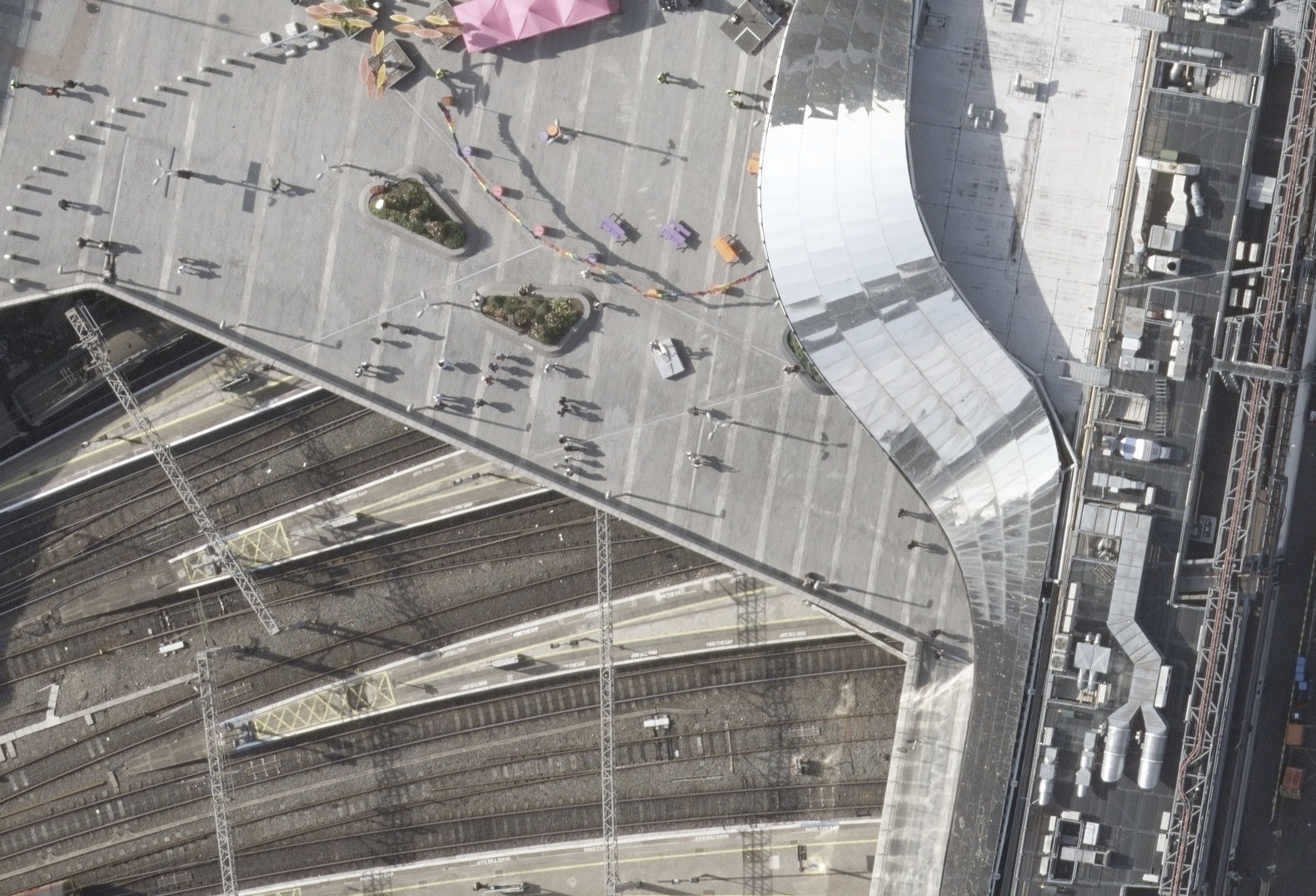
In addition to traditional vertical imagery, Getmapping also offers oblique aerial imagery. Oblique imagery provides multiple angled views of the same location, allowing for a more comprehensive visualization of an area. This type of data is often used for urban planning and 3D modeling.
Getmapping on the UP42 marketplace
The UP42 platform serves customers all around the globe, with data from the world’s leading providers. In addition to aerial imagery, we also host satellite imagery, digital elevation models, and more, along with a wide range of analytics tools.
“We are proud to be partnering with UP42. It is great news that they are taking full advantage of our new 5 cm CityView content to provide users with access to highly detailed imagery of towns and cities across the UK, updated every year, and supporting the growing demand for higher resolution and higher currency insights”, says Dave Horner, Getmapping CEO.
The following Getmapping products are now available on the UP42 marketplace:
- 5 cm CityView imagery of the major cities in the UK, with annual updates
- 12.5 cm NationalView aerial imagery of Great Britain
- 25 cm NationalView aerial imagery of Great Britain
Visit the marketplace and try them out today.


Subscribe to our newsletter
Stay up to date and learn about our fast-growing new features
