How satellite imagery helps with construction monitoring

Imagine you are overseeing the development of a vast infrastructure project spanning different locations.
On a typical day, you visit the site to assess construction progress, review issues, and detect deviations from the budget and schedule. You subsequently prepare weekly progress reports based on your observations and on-site monitoring data from other teams.
In addition to progress monitoring and reporting, you also keep an eye on ground subsidence in and around the site, infrastructure stability, and the impact of construction on nearby vegetation.
Furthermore, you must address unanticipated site conditions, regulatory requirements, and community concerns. Despite your best efforts, manual monitoring falls short. The project is not completed on time and within budget.
Unfortunately, this is not a unique case.
A 2015 KPMG survey of construction projects revealed that 53% of respondents had experienced underperforming projects in the previous year, with most facing budget overruns.
But what if there was a better way? What if you incorporated satellite imagery?
This article examines how satellite imagery complements manual monitoring in architecture, engineering, and construction (AEC) projects.
What is construction monitoring, and why is it important?
Construction monitoring is the process of ensuring that a construction project is on time, within the budget, meets quality standards, and complies with health, safety, and environmental requirements. It involves gathering data on construction activities, analyzing the data, and reporting the results to stakeholders.
Monitoring is important for
- Progress measurement and reporting
- Identifying potential issues for timely decision-making
- Reducing the risk of delays, cost overruns, disputes, etc.
What are the drawbacks of traditional construction monitoring?
Traditionally, construction monitoring data is gathered manually through on-site inspections or land surveys. However, manual collection methods are labor-intensive, time-consuming, and error-prone. Why? Construction sites are often vast and involve the simultaneous execution of different tasks. Reliance on manual methods alone leads to delays and increased costs.
Issues also arise during reporting, which shares the same problems with data gathering. Furthermore, there may be inconsistencies in data collection, making it challenging to interpret and analyze data accurately. Moreover, the reported progress may be subjective, as it is based on the interpretation of the construction status by field personnel.
Consequently, communication gaps between project stakeholders (e.g., architects, contractors, and subcontractors) may arise, leading to misunderstandings, delays, and cost overruns.
The good news is that satellite imagery can help mitigate some of these challenges.
As we shall see, satellite imagery offers a wider coverage and objective perspective. It enables remote monitoring of construction sites, allowing for frequent and consistent data collection over large areas. This improves the efficiency, accuracy, and reliability of construction monitoring, leading to better communication, timely decision-making, and improved project outcomes.
What types of satellite imagery help with construction monitoring?
Satellite images are Earth's surface as captured by sensors mounted on spaceborne platforms. They provide a snapshot of the features of the Earth's surface and enable their interpretation and analysis.
Depending on the lighting source, satellite imagery is captured by passive or active sensors. Passive sensors measure reflected energy. The captured images are optical, thermal, or passive microwave imagery.
Active sensors, on the other hand, emit energy to the Earth's surface and measure the reflected or backscattered energy. This is how Synthetic Aperture Radar (SAR) satellites capture their imagery.
In this article, we'll primarily be talking about optical and SAR data. For a deeper dive into satellite imagery types, check out our detailed guide.
Benefits of satellite imagery for construction monitoring
Satellite imagery provides vital insights during construction monitoring. This table highlights the key benefits of incorporating satellite imagery.
Applications of optical satellite imagery in construction monitoring
Optical satellite images are collected in the visible and infrared regions of the electromagnetic spectrum. The images mimic how we see with our eyes, enabling visual monitoring of the construction progress. Further, optical images capture the spectral variations of various features, enabling their differentiation.
We now examine how these capabilities benefit infrastructure monitoring.
Satellite imagery facilitates construction progress monitoring and reporting
Construction progress tracking and reporting are critical for ensuring timely and well-informed decisions and faster dispute resolution. However, relying solely on in-person manual inspections can be challenging–particularly for large construction projects with multiple teams spanning a large geographical extent.
Satellite imagery offers the opportunity to capture construction progress regularly. Very high resolution images, such as the 30 cm imagery provided by Pléiades Neo, provide detailed views of construction progress. The benefits include:
- Visualization of progress status ensuring all stakeholders are on the same page and reducing miscommunication
- Near real-time updates of construction progress supporting decision-making and reducing delays
- Reduced need for frequent on-site monitoring, saving on time and costs
Satellite imagery also enables automated progress monitoring of projects with repetitive construction stages such as roads and railways. For such projects, the temporal patterns of construction activities can be visually identified, enabling model training and subsequent automated change detection.
Overall, satellite imagery provides an independent complementary dataset to on-site progress reports and enables timely identification of construction delays. It offers a valuable tool for stakeholders to stay informed, and address construction challenges effectively.
Satellite imagery enables monitoring of the environmental impacts of construction
Monitoring infrastructure construction impacts on the landscape and environment is crucial. Why? Because it informs mitigation measures during construction and facilitates the restoration of degraded lands after construction. Here, too, satellite imagery offers monitoring opportunities.
First, satellite imagery enables the detection and quantification of the environmental changes caused by construction by using indices derived from multispectral and hyperspectral images. For instance, variations in the Normalized Difference Vegetation Index (NDVI) and Normalized Difference Moisture Index (NDMI) make it possible to monitor vegetation stress arising from construction-induced factors like dust deposition on vegetation.
Second, satellite images enable land use land cover (LULC) change mapping, aiding in environmental impact assessment over the construction period. For example, the images below depict the LULC changes before, during, and after highway construction.
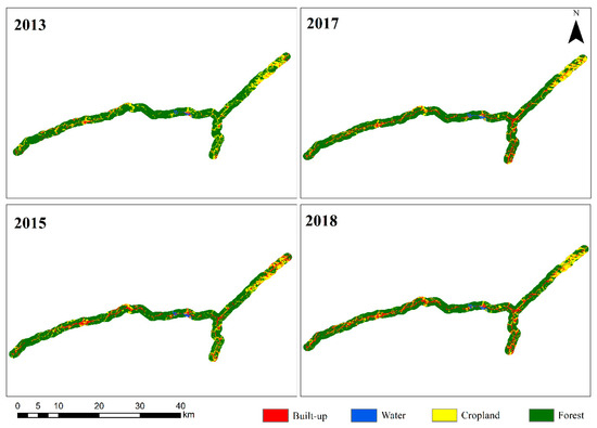
In general, satellite imagery aids large-scale detection of environmental impacts that are invisible to the eye. The analyses enhance our understanding of the relationships between infrastructure construction and the environment and help to ensure environmental protection.
Applications of SAR imagery in construction monitoring
Synthetic Aperture Radar (SAR) images are Earth's surface images collected in the microwave portion of the electromagnetic spectrum.
Several SAR imagery characteristics make it a valuable tool for construction monitoring. More specifically, they are:
- Weather and daylight independent, enabling day and night construction monitoring–even in areas with persistent cloud cover where optical imagery is limited.
- Sensitive to the moisture content of surfaces, enabling the detection of variations in soil water content.
- Able to penetrate surfaces depending on the wavelength frequency and the object size. Longer wavelengths can penetrate dense canopies to reach the ground, further facilitating construction monitoring.
Let us see how these characteristics come into play during construction monitoring.
Discover how SAR data is complementary to optical.
SAR enables the monitoring of ground deformation due to tunneling
The construction of underground transportation infrastructures beneath densely populated urban areas may cause ground subsidence, which can lead to damage to surface buildings and structures. Therefore, it is essential to measure and track subtle ground movements.
Traditional methods, such as leveling, offer accurate measurements but rely on a limited number of control points. Additionally, leveling can be time-consuming and expensive for consistent monitoring.
SAR imagery greatly enhances ground deformation monitoring during tunneling activities. By employing the Interferometric Synthetic Aperture Radar (InSAR) technique, SAR imagery enables the detection of millimeter-scale ground deformation. InSAR uses two or more SAR images acquired at different times or from slightly different positions.
A comparative study that evaluated leveling and InSAR in urban underground construction monitoring found that both methods deliver similar levels of precision when used for deformation monitoring in construction environments.
However, SAR imagery offers several advantages.
- Comprehensive monitoring dataset: InSAR provides a dense set of measurement points resulting in a more comprehensive dataset for monitoring ground deformation.
- Large area coverage: SAR imagery covers a larger area, offering the opportunity to monitor both the site under construction and the surrounding infrastructure.
- Regular monitoring opportunities: SAR satellite imagery is captured regularly facilitating frequent monitoring. For instance, TerraSAR-X imagery provides the opportunity for monitoring every 11 days.
Overall, both leveling and SAR imagery offer valuable data for identifying surface movements during construction. Integrating these complementary datasets provides a more comprehensive understanding of tunneling-induced ground subsidence.
In addition to monitoring surface movements resulting from the construction of underground infrastructure, it is equally important to monitor the deformation associated with aboveground structures.
SAR aids in the stability analysis of aboveground infrastructure
The movement of newly constructed infrastructure, whether caused by factors like loose rock, landslides, or groundwater pumping, can pose deformation and safety risks to the infrastructure itself and the surrounding area.
Likewise, movement in the existing surrounding infrastructure also presents a risk. Hence, regular deformation monitoring near construction sites is critical for early warning.
While site visits, surveying measurements, or geotechnical sensors can aid in identifying at-risk areas, they only enable monitoring at a few key positions on the infrastructure and within a small geographic area.
SAR interferometry methods like differential SAR (DinSAR) and Persistent Scatterer Interferometry (PSI) extend the scope of stability monitoring to cover a large portion of the structure over a wide area.
Additionally, some SAR satellites offer flexible acquisition modes, allowing for both wide-area overviews and detailed stability monitoring of small areas. For example, TerraSAR-X imagery acquired in the Stripmap mode covers a standard scene size of 30 km × 50 km, with a spatial resolution of 3 m, for wide-area monitoring. Meanwhile, imagery captured in Staring SpotLight mode covers a 4 km x 3.7 km area, with a spatial resolution of up to 25 cm, enabling multiple independent deformation measurements on a single structure.
In summary, SAR technology, specifically through DinSAR and PSI methods, enhances infrastructure stability monitoring. By utilizing SAR imagery, it becomes possible to monitor a large portion of the structure over a wide area, providing valuable insights for early detection and mitigation of potential deformation risks.
Read about how TerraSAR-X imagery was applied in dam monitoring.
SAR imagery helps to detect surface moisture
Changes in soil moisture levels affect the stability of the ground on which infrastructure is built. If left unchecked, moisture changes can lead to infrastructural damage and costly repairs. Therefore, monitoring moisture content fluctuations is crucial for identifying areas prone to failure, implementing preventative measures, and minimizing the risk of damage.
Traditional methods of determining soil moisture content include
- Laboratory testing of soil samples
- On-site testing using soil moisture meters
However, traditional methods require field crews, which is labor-intensive and time-consuming, especially over vast areas. Furthermore, these methods only provide sample measurements at specific data collection points.
SAR satellite imagery offers a way to improve soil moisture detection.
SAR can measure the intensity of the backscattered radar signal, which is higher if a surface has high water content. As such, SAR imagery facilitates wide-area retrieval of soil moisture content at multiple measurement points without extensive fieldwork.
Moreover, SAR enables the mapping of spatiotemporal fluctuations in soil moisture content. This means that you can monitor changes in soil moisture content over time, providing early warnings for potential areas of infrastructure failure. With this information, you can deploy field crews for detailed inspection and preventive actions.
What satellite imagery cannot do in construction monitoring
While satellite imagery is a powerful tool for construction monitoring, it is important to understand its limitations. This helps to set realistic expectations and identify situations that require alternative monitoring methods.
Here are some things that satellite imagery cannot do in construction monitoring:
- Monitor objects and surfaces hidden from the line of sight: Satellite imagery cannot penetrate inside buildings or capture the undersides of bridges or other structures which are obstructed from the satellite's line of sight. It can only monitor what is visible from above.
- Provide real-time continuous construction monitoring: Satellite imagery data collection time and frequency are limited to the satellite's revisit times. Depending on the satellite system, the revisit frequency can vary from several days to daily. For example, Sentinel-2 satellites revisit the same point on Earth every 5 days, whereas Pléiades Neo revisits daily. As such, real-time monitoring of construction activities on a specific day and time may require additional methods like ground surveys. That said, satellite tasking helps to overcome this challenge.
- Detect north-south horizontal displacement using SAR imagery: SAR satellites are side-looking and usually point to the right of their travel direction. Therefore, they are suited for detecting upward/ downward and east-west surface movements rather than north-south displacements.
- Monitor deformation in areas that lack persistent scatterers: Deformation monitoring using SAR imagery relies on detecting persistent scatterers. Persistent scatterers are long-term stable points or structures used for measurement. This means that deformation monitoring is challenging where persistent scatterers are lacking (e.g., in heavily vegetated areas). In such cases, installing artificial reflectors is necessary to facilitate measurements.
Satellite imagery: Valuable beyond construction monitoring
While satellite images cannot fully replace on-site construction monitoring methods, they can improve the monitoring process in several ways.
Unlike manual monitoring, which requires the physical presence of the person or equipment on-site, satellite images are non-intrusive, supporting the monitoring of construction activities in inaccessible areas.
Satellite images provide a near-real-time synoptic view of the construction progress facilitating timely decision-making. This is in contrast to progress report compilation based on manually collected data which is tedious and time-consuming, meaning that when you submit the report, the project status and progress may no longer be valid.
Another advantage of satellite imagery is its ability to cover extensive areas enabling wider-scale monitoring compared to manual monitoring, which covers small areas.
Satellite images also provide insights beyond the construction stage.
By incorporating satellite data during feasibility studies, you can identify unforeseen challenges like ground instability and potential environmental issues before construction begins. This early detection improves project planning and reduces project delays.
Post-construction, satellite imagery plays a critical role in infrastructure maintenance. It helps to identify potential areas of concern, reducing the likelihood of catastrophic failure. Additionally, satellite imagery provides a safe and cost-effective alternative to scheduled site visits.
It's time to use the advantages of satellite imagery at every stage of your AEC project. Need assistance? Contact us. We'd be happy to help.


Subscribe to our newsletter
Stay up to date and learn about our fast-growing new features
