What’s new
Release notes
Keep up with the latest releases and improvements.

EROS-B and EROS-C archive data from ISI now available on console and API
We're adding two more very high resolution optical satellite imagery collections to the UP42 platform!
- EROS-B offers very high resolution 50 cm optical satellite imagery, acquired worldwide with a revisit rate of 2 days. Catalog datasets are available starting from 2006.
- EROS-C offers very high resolution 30 cm optical satellite imagery, acquired worldwide with a daily revisit rate. Catalog datasets are available starting from 2021.
Our new pansharpening algorithm: now on console too
Two weeks ago we introduced our brand new pansharpening algorithm, our first advanced processing capability. You can now try it out directly on the console. Here is how:
- In the map section, select the scenes you want to process
- The selected scenes are automatically validated before processing—no actions for you
- If a scene is not suitable for processing, we will tell you why and give you the option to remove it from the selection
- In the case of pansharpening, scenes need to contain both panchromatic and multispectral bands
- You can then pansharpen all compatible images (as many as you want) and track the status in the new Jobs table
- That's it, you can now use the data for your downstream use case.
And the best part—pansharpening is currently free of charge.
An exampe of a pansharpened image
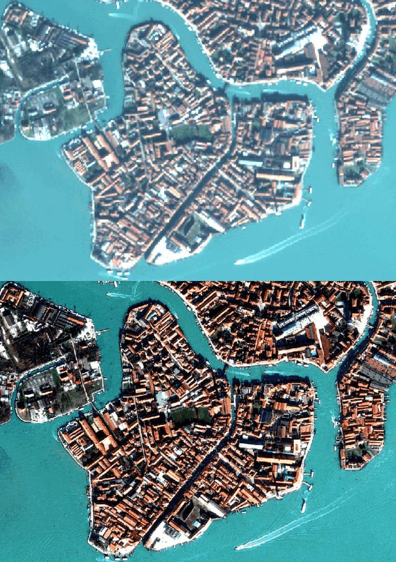
Pléiades, Airbus
You can find more information about the requirements, input, and output in our detailed technical information. Try out pansharpening on the console today.
Brand new pansharpening algorithm: our first advanced processing capability
We're fully integrating our analytics capabilities into the platform. You can now process any order delivery via our data management component. Most importantly, the output will be available in our STAC endpoints too, accessible through the same component. The process is more scalable—you can now apply our advanced processing capabilities to as many scenes as you want, as long as they’re compatible. It is also easier to scale—the end output will no longer be stored in the project itself, but in your data management component, making it easier to use the data for your downstream use case. Now let’s review a more practical example: pansharpening.
Short for panchromatic sharpening, pansharpening is an image fusion technique that increases the image to the resolution of the panchromatic band. It combines the higher-resolution panchromatic band with a lower-resolution multispectral band to yield a high spatial and spectral resolution image. You can now pansharpen your scenes directly on our platform using the Brovey method.
You will be able to automatically see which scenes are suitable for pansharpening, e.g., which scenes contain both panchromatic and multispectral bands. We will provide automatically optimized grey weights—no need to specify anything yourself.
The algorithm consumes and returns data and metadata that is STAC and CNAM compatible. It allows you to select an unlimited number of scenes and pansharpen them, instead of doing so individually for each scene. You can apply the algorithm by defining its STAC item ID. The pansharpened asset will be added to your account as a new STAC item, accessible via /v2/assets/stac endpoints.
Pléiades, Airbus
And the best part—pansharpening is currently free of charge. You can find more information about the requirements, input, and output in our detailed technical information. Try out pansharpening on the UP42 platform today.
New tasking flow with easier ordering and instant price estimation
We’ve made some exciting new changes to the tasking ordering flow. Now you can view the list of available collections and their specifications upfront, upload geometries to validate compatibility, get an instant price estimate for your order, and view a complete summary of your order before submitting.
More very high resolution data from Pléiades Neo on the UP42 catalog
You can now access the full Pléiades Neo archive via the UP42 catalog. What's new?
- Nearly 340 million km2 of Pléiades Neo data is now available on the platform—a 6-fold increase in the availability of very high resolution 30 cm data on the UP42 platform.
- The minimum order size has been lowered to 5 km2.
Access the full Pléiades Neo archive through our console or via our API.
Explore the UP42 platform
Create an account to order, access, and analyze geospatial data.
