See heat patterns with thermal intelligence from constellr

UP42 is excited to welcome constellr as a partner. We sat down with Max Gulde, constellr's CEO, to talk about the company and their solutions, as well as the increasing importance of thermal intelligence.

1) Can you tell us a little bit about constellr as a company? When, where, and why was it founded?
constellr was founded in 2020 in Freiburg, Germany, with roots in the Fraunhofer ecosystem, which bridges academic research and industrial application through proprietary calibration and data processing technologies. The “why” was simple: the world is heating up, but decision-makers still lack consistent, high-quality temperature information at the scale where actions happen. Our mission is to build a thermal intelligence atlas of the planet to support climate action and sustainable resource use. As a first important step, we are supporting a sovereign Europe with our assets.
2) Could you tell us about your satellite constellation, HiVE, and its history?
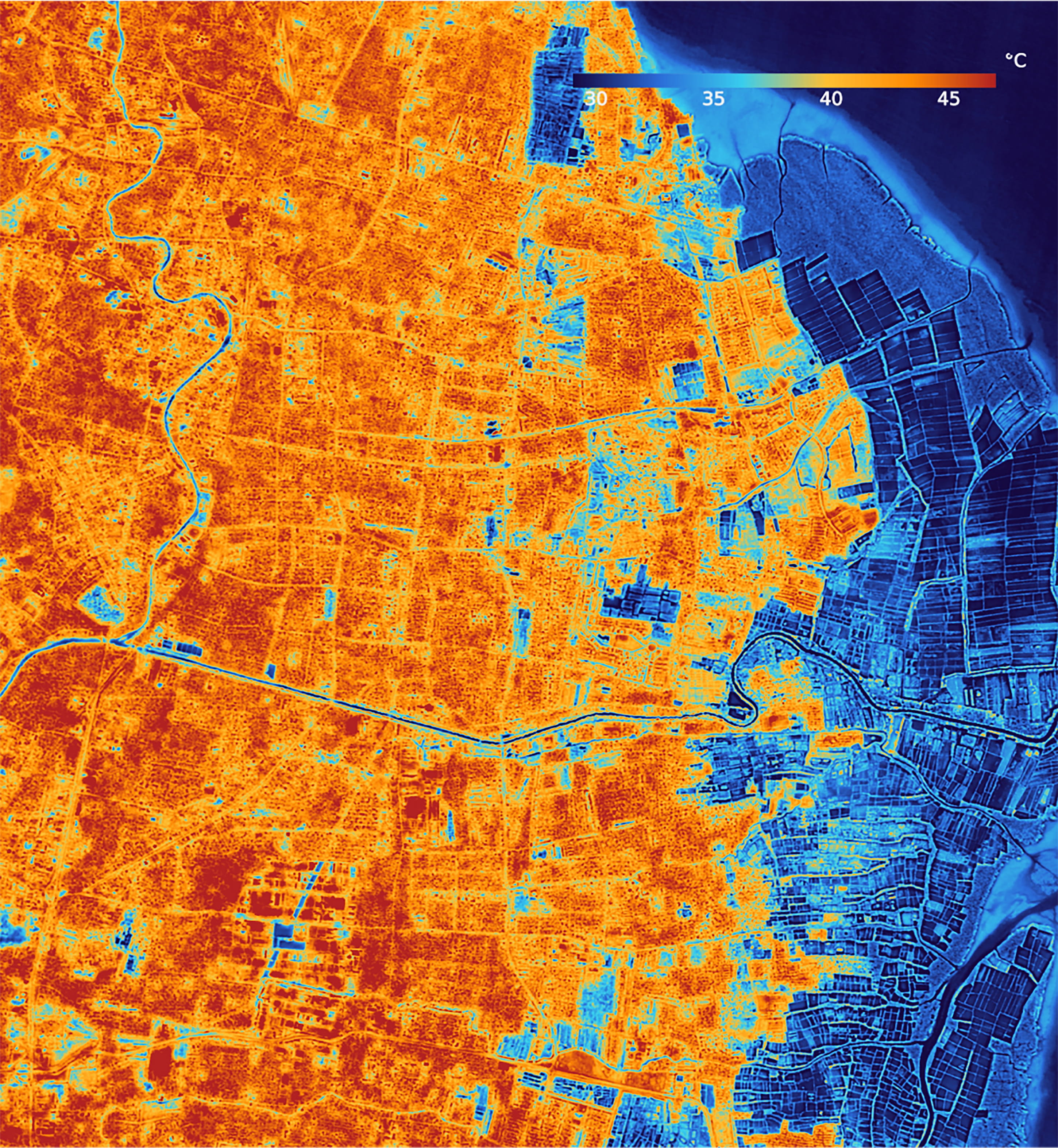
HiVE (High-precision Versatile Ecosphere) is our thermal Earth observation constellation designed to deliver high-resolution Land Surface Temperature (LST) with frequent revisit. HiVE’s first satellite, SkyBee-1, launched in January 2025, and the constellation now includes SkyBee-1 and SkyBee-2 (launched June 2025) enabling sub-daily revisit, day and night.
3) Tell us about constellr’s offerings. How do they help to solve real-world problems?
Our portfolio is built around turning temperature into operational insight across domains, from agriculture to defense:
- LSTfusion: cloud-free, modelled daily LST at 30 m by combining constellr measurements with other sources for continuity at scale
- LSTprecision: high-precision, frequently updated LST at 30 m for reliable absolute temperature monitoring
- LSTzoom: higher “sharpness” layer designed to support detailed local analysis (10 m spatial detail layer)
Use cases span security & defense, agriculture and water, urban heat and resilience, and infrastructure and industrial monitoring, where temperature often reveals stress, inefficiency, or anomalies before they show up visually.
4) What are some ways that thermal data can be used with other types of Earth observation data?
Thermal becomes far more powerful when fused with:
- Optical/VNIR for vegetation indices and surface context (what is it?) alongside temperature (how is it behaving?)
- SAR for structure and moisture-related signals, especially when clouds block optical, i.e., for maritime awareness
- Weather and reanalysis data to separate “hot because of weather” from “hot because something changed on the ground”
- Land cover, DEM/elevation, and infrastructure layers to attribute drivers and quantify risk
5) What are the biggest untapped areas of opportunity for thermal intelligence?
A few that we think are still underexploited:
- Security and defense (critical infrastructure monitoring, maritime awareness)
- Industrial decarbonization and efficiency (process heat, losses, abnormal heat signatures)
- Urban adaptation (hyperlocal heat-risk targeting, verifying cooling interventions)
- Water risk and crop productivity (moving from “where is it dry” to “where is transpiration dropping right now”)
- Climate finance and resilience verification (measuring outcomes, not just plans)
6) And the biggest barriers facing wider adoption of thermal data right now?
In practice, adoption is often held back by:
- Data continuity and revisit (thermal has historically been infrequent at high resolution)
- Clouds and gaps (and the need for robust gap-filling and uncertainty)
- Calibration, comparability, and trust (users need consistent accuracy across time and regions)
- Integration friction (getting thermal into existing EO workflows, not as a separate science project)
7) Why did constellr decide to partner with UP42? What does it mean to your company?
We partnered with UP42 because we see them as the most relevant entry door into that market. We are extremely selective about partnerships, and UP42 gives us a scalable route to meet users where they already procure and operationalize EO, with standardized access patterns that reduce integration and contracting overhead.
8) What’s next for constellr?
We are focused on scaling thermal intelligence from “great data” to “always-on capability” at defense-grade performance specs
- Launching our next generation with sub-5-meter resolution and defense-grade performance
- Expanding constellation capacity and product layers as we build toward a continuously updated thermal atlas
- Broadening accessibility through institutional and commercial channels, including new distribution pathways and partnerships
Place an archive or tasking order, or learn more in our documentation.

Subscribe to our newsletter
Stay up to date and learn about our fast-growing new features
