


Nature has a mind of its own. Where no human sets foot, it takes over whatever is in its way, unpredictably. For utility companies, this means that high-voltage lines are under constant threat from fallen and overgrown trees, with consequences ranging from power outages to fire outbreaks.
Vegetation management is the response to an issue that costs larger utility companies in the US [over 30 billion in damage caused by blackouts.
If timely maintenance and monitoring are critical to identifying assets prone to spark a fire, choosing the right technology to make this task more efficient is of utmost importance. Ideally, the right tool will help guarantee an uninterrupted supply of energy while also protecting the surrounding environment.
An increasing number of utility companies are turning to remote sensing to monitor linear infrastructure -- in stark contrast to what used to be a manual, costly, and time-consuming operation. However, there are several innovative technologies within remote sensing, each with its benefits and drawbacks, so that choosing the right one for your business can be a challenge.
For the purpose of this article, and in order to evaluate the ultimate benefit for your business, we will examine three remote-sensing solutions playing a critical role in vegetation management: LiDAR, drones, and satellite imagery.
LiDAR for Rich Data and Accuracy
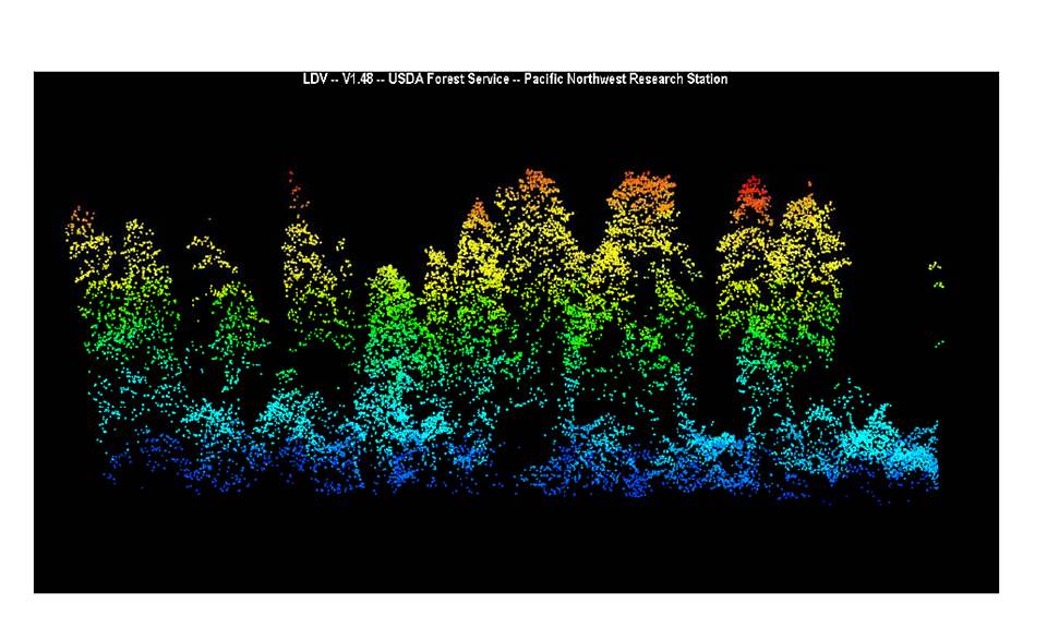 Image of a Douglas-fir canopy in the H.J. Andrews Experimental Forest. Photo: Andrew Ngeow, courtesy of Oregon State University
LiDAR is an optical remote sensing technology based on "light detection and ranging" that measures the light reflected by ground objects and transforms it into accurate 10-50 cm resolution digital elevation models (DEMs), depending on the device. In vegetation management, LiDAR is a popular solution to scan portions of forests and detect elevation.
A scanner often used in combination with helicopters, LiDAR has now reached a sufficient degree of compactness such that it can be easily used as a drone payload. This has dramatically reduced the costs associated with its usage and transportation compared to traditional vehicles, but there remain some drawbacks and limitations when it comes to data interpretation:
-
LiDAR's highly accurate data requires an intense work of interpretation and analysis often carried out by external experts, resulting in additional costs. Furthermore, the conspicuous amount of data makes it sometimes impractical to identify critical details such as a fallen tree, requiring additional insights from satellites.
-
LiDAR results could take from weeks to years to be ready to be acted upon. By the time reports are generated, the data may already be outdated, requiring the process to be immediately repeated.
-
It is possible to estimate trees' growth with LiDAR and obtain some health information such as presence or absence of leaves. But we have no factual information about the general health condition of those plants. In this particular case, LiDAR is often used in combination with satellite imagery (high-resolution multispectral) to gether precise information on the greenness of the vegetation.
Drone Imaging and Photogrammetry for Ad-hoc Inspections
 Conservation drones using GIS. Photo: Cliffspiration
The use of camera-equipped drones for enterprises is on the rise and has quickly moved from being a novelty to becoming a day-to-day tool surveyors swear by to get the job done.
In vegetation management, drones are often used for detailed surveys rather than monitoring at a larger scale due to their average range of 12 km. Once the data acquisition on a large portion of vegetation around distribution lines is performed through LiDAR or satellites (often in combination), drones are then used to intervene on a single tower to perform all the necessary inspections while also eliminating safety risks for operators.
Drone inspections rely on photogrammetry (also performed through helicopters), which is sometimes used as an alternative to LiDAR technology and in combination with satellite imagery. Thanks to orthomosaic mapping, 3D models, or multispectral camera-generated NDVIs (normalized difference vegetation index), photogrammetry is key to measure the encroachment of trees along power lines as well as the health of vegetation -- only on a smaller scale.
However, when compared against LiDAR, photogrammetry lags behind in terms of accuracy and it may require more than one flight to ensure an absolute level of accuracy. Even in this case, it is the combination of drone and satellite imagery that gives businesses a comprehensive insight into trees and bushes overgrown along electric corridors rather than one single remote sensing solution.
Satellite Imagery for Insightful Data on a Large Scale
 Satellites showing trees above a certain height, in relation to their distance from the railway.
Last but certainly not least, satellite imagery is the go-to solution for many utility companies looking to protect critical infrastructure.
Often used in conjunction with optical remote sensing technologies such as LiDAR (to detect elevation), drone photogrammetry (for encroachment and vegetation's health), or even aerial imagery (for highly accurate 3D representation of the Earth's terrain) satellite imagery compares relatively better for a series of reasons:
-
With nearly 6,000 satellites orbiting around the Earth, we have reached a high level of affordability that is only set to increase.
-
With a single acquisition, satellites can cover 3600 km² or more, with an accuracy of 50 cm, saving time and resources with just one monitoring, whereas other solutions require multiple operations.
-
Satellites imagery can help generate highly accurate information on the general condition of vegetation, namely:
-
Health: This insight enables growth prediction based on actual conditions rather than generalized estimations.
-
Dryness: This insight is paramount to assess the risk of wildfires and ultimately protect the wildlife around the infrastructure.
-
Satellites are in constant orbit around the Earth, facilitating quick, real-time data updates and allowing for more precise and timely interventions.
In summary, satellite imagery offers a clear advantage in vegetation management for utility companies when it comes to three key intrinsic features:
Reliability: Satellite imagery is highly accurate and constantly up to date.
Flexibility: Satellite imagery can be used in combination with LiDAR and drones to compensate for their drawbacks.
Accessibility: Satellite data are publicly available and more affordable than any other types of equipment.
Ultimately, all three technologies have a specific purpose, and we encourage utility companies to choose a solution that works best for their specific case, whether that is a more detailed power line inspection with drones or a high-level analysis with LiDAR.
But when the direct result of using satellite data for vegetation management is that companies can save up to 20% of their annual budget for vegetation management with a single mission, the message is clear: nature may be unpredictable but you are still in control of your business.
Learn more about remote sensing technology for infrastructure monitoring and vegetation management directly from our customers in our recent webinar and on our website.


