What’s new
Release notes
Keep up with the latest releases and improvements.

UP42 - Your Data Partner
We have 50 different data sets on the UP42 marketplace that can be seamlessly accessed through the console or API. But did you know that you can also easily task a satellite or order custom data with us?
We're excited to share our new Order Data page, outlining our extensive and expanding tasking and custom data ordering options. On this page, you will find a selection of industry-leading optical, radar, and aerial data providers.
Our team of geospatial data experts are here to help you every step of the way. They’ll be happy to advise you on the best constellations for your use case and in no time at all, they’ll be ensuring the safe delivery of your data sets to the UP42 platform and available via API to integrate into your own data ecosystem.
Launching Our New Documentation Hub
We aim to provide a seamless out of the box experience with the UP42 platform, but with such a wide variety of capabilities both within the core platform and offered by our amazing partners, some pointers are sometimes needed.
Launching our new Documentation Hub - a central place to find information on how to use the UP42 platform, our data and processing capabilities, and the Python SDK and API. The Documentation Hub is a complete overhaul of our documentation, carried out with user experience front and center.
This clean, fresh uncluttered approach will allow you to quickly find what you’re looking for whether you’re a product manager trying to search and order satellite imagery from the archive or a data scientist building and selling algorithms through the UP42 marketplace.
Keep your eyes peeled in the coming days for a blog post from John Ngo, our Senior UX Designer, who will discuss how the Documentation Hub was developed with you, the user, in mind. And in the meantime, head over to the Documentation Hub and let us know what you think!
Sentinel-2 L2A Analytic and Pan-Sharpening
Last month, we announced our new Sentinel-2 block that provides access to the latest 12-bit Sentinel 2 imagery, ideal for processing and analytics purposes. This block comes with 12 spectral bands from visible and NIR to short-wave IR, enabling a wide range of use cases.
However, most analytics and processing capabilities require all bands to be processed at the same resolution. As such, this block is now compatible with our Pan-Sharpening block. This enables you to upsample all 13 bands to a 10m resolution and consolidate them into a single GeoTIFF file that can be easily processed and connected to a range of analytics.
Scale Your Analysis
We've relaxed our limits on the maximum AOI from 1000km2 to 180,000km2 and the number of jobs you can run concurrently from 10 to 1000. This allows you to parallelize your analysis more efficiently and cover more land than ever before.
Unified Search Results
You can now search and discover data to purchase or process in one unified set of search results. We’ve added tags to the catalog search results to differentiate between data that can be purchased or processed.
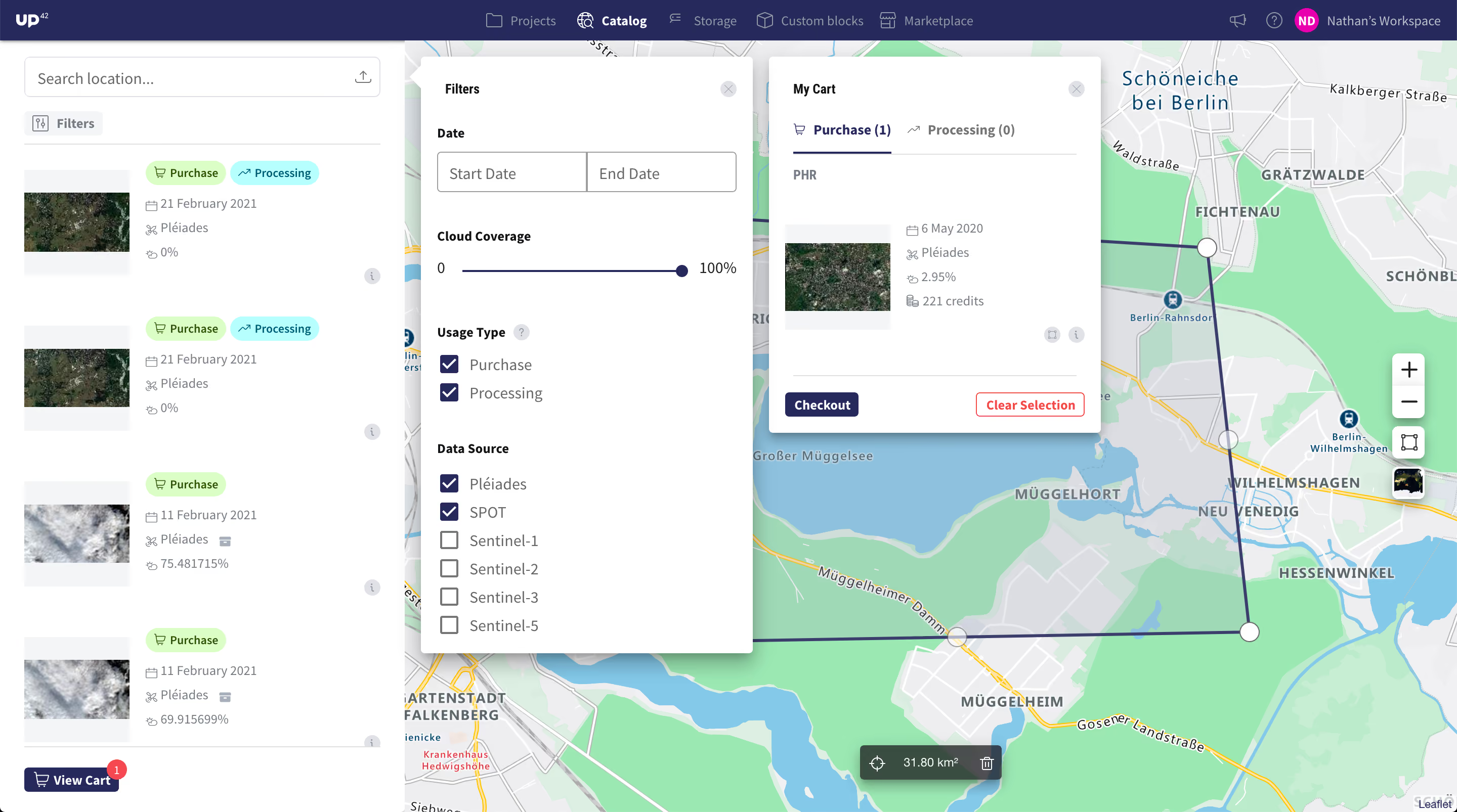
Sentinel-1, 2, 3, and 5 imagery that can only be processed is marked only with the tag “processing”, while Pléiades and SPOT imagery in archived cold storage is tagged with “purchase”. The latter is ordered and delivered to your user storage within 24 hours. Pléiades and SPOT imagery that is warm is tagged with both “processing” and “purchase” and is available almost immediately.
You can also use the “Usage Type” search filter to narrow your results to either data available to process or purchase. Finally, in the “Cart”, you can switch between “Purchase” and “Processing” tabs, depending on whether you want to order data for download or configure a job to process your selected data.
Explore the UP42 platform
Create an account to order, access, and analyze geospatial data.
