Utility vegetation management: Elevation models and stereo imagery for DEM generation
We’ve written extensively about elevation data in different blogs in the past, so in this article, we’ll keep the introduction short. In a recent blog, we also talked about how you can augment utility vegetation management with satellite imagery. Here, we'll discuss the advantages of archive elevation models, as well as tasking a satellite and using stereo imagery for DEM generation–all made possible through the UP42 platform.
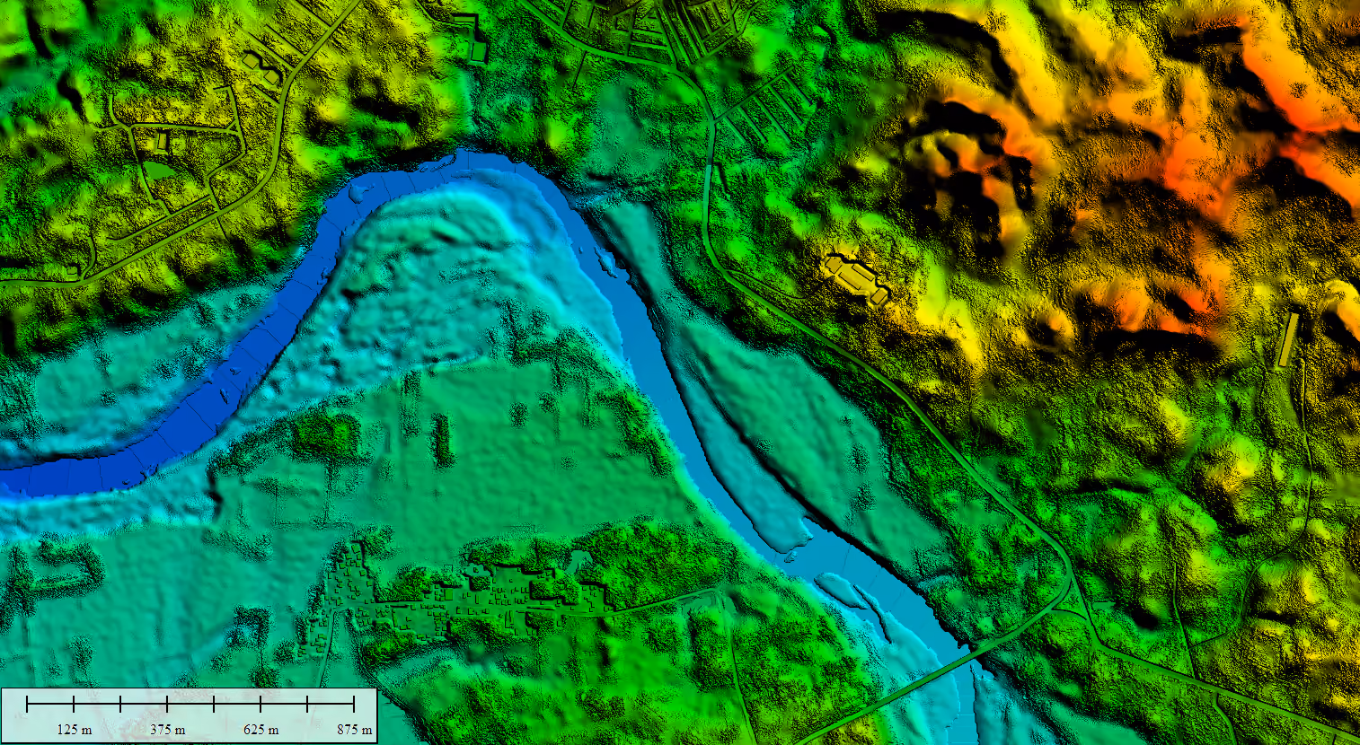
Elevation data helps you get a better understanding of the earth’s surface, including structures. Different types of elevation data can be captured by satellites, helicopters, planes, or drones.
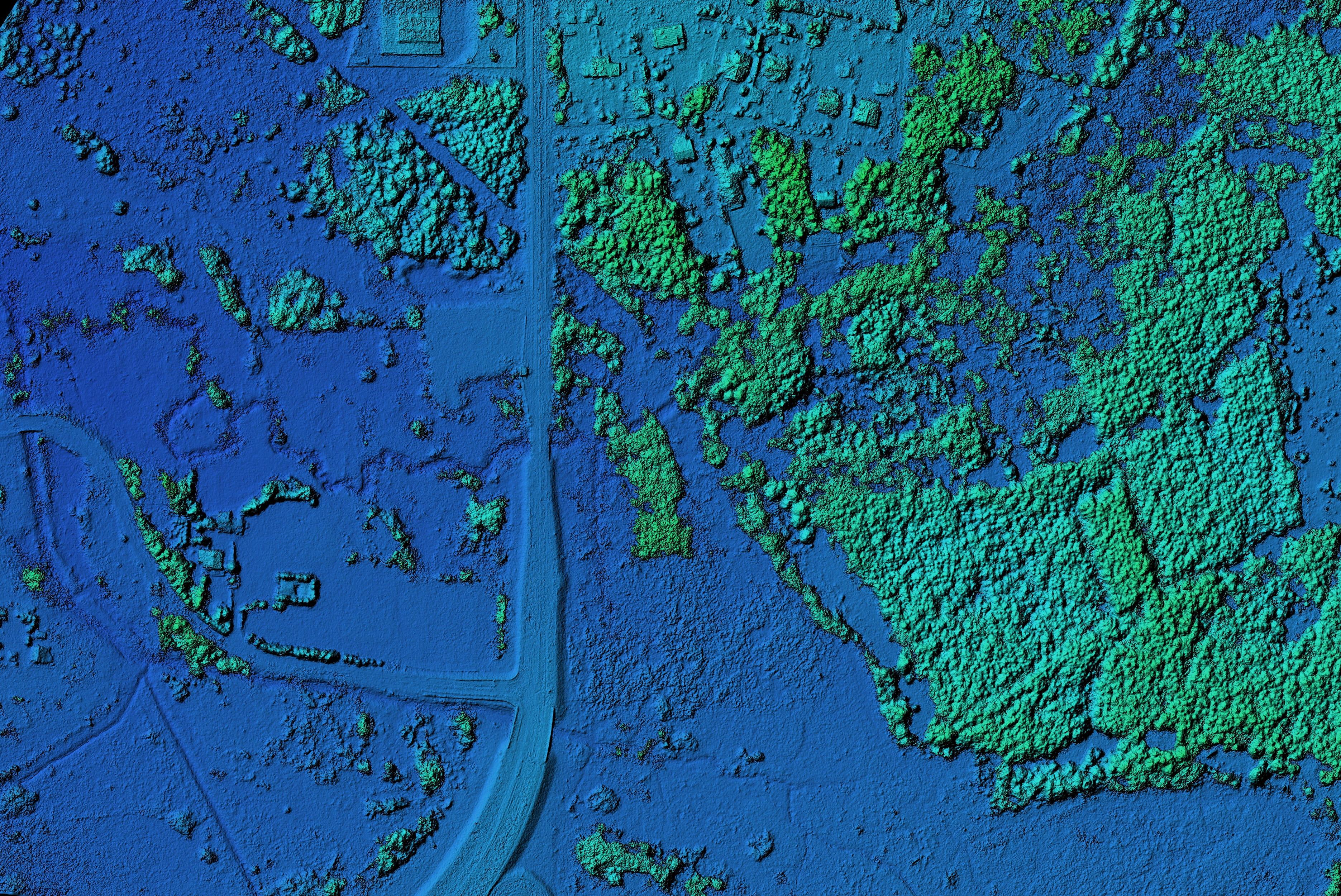
- Digital Surface Models (DSMs) represent elevations of natural (mountains, trees) and human-made structures (e.g., buildings, infrastructure). They illustrate the earth's surface and all objects on it.
- Digital Terrain Models (DTMs), on the other hand, are bare-earth models devoid of human-made and natural structures. DSMs can be turned into DTMs by removing non-ground objects using a method called interpolation–but the higher the amount of vegetation, the harder the process becomes.
Elevation models play a critical role in monitoring vital infrastructure. They provide a detailed view of the terrain, including vegetation cover and other features. Elevation data serves as an input to infrastructure planning, ensuring that construction of railways, pipelines, and power lines is not planned across high-slope areas. It can also be used to track differences in elevation and ensure that hazards such as vegetation encroachment are monitored, predicted, and mitigated, minimizing damage and outages. Below are some examples of how you can use elevation data to identify potential risks and plan interventions such as thinning or removal.
- Compute vegetation height by subtracting a DTM from the corresponding DSM and assessing risk to infrastructure. You can read more on this topic here.
- Estimate the volume of vegetation and assessing the potential impact on infrastructure.
- Identify or track changes such as height and density in vegetation over time to assess risk.
- Improve your vegetation management analysis by resolving false positives that can arise when using satellite 2D images. By overlaying satellite data onto elevation data, you can more easily identify inconsistencies and errors.
UP42 brings together elevation data alongside optical and SAR satellites, aerial imagery, weather data, and more. You can order NEXTMap® and WorldDEM™ Neo elevation data directly from the UP42 platform, using our API, Python SDK, or console, and then integrate the data directly into your pipelines.
NEXTMap® Elevation Data Suite
Intermap provides up to 1 m resolution elevation products in their Elevation Data Suite, enabling precise spatial analysis. NEXTMap is available as a natural terrain feature DSM or as a bare earth DTM. All NEXTMap DSM, DTM, or bundle products are available at 1 m, 6 m, and 10 m resolutions. You can check coverage here.
WorldDEM™ Neo
WorldDEM™ Neo from Airbus is an edited DSM that provides up-to-date global coverage and very high resolution at 5 m pixel spacing. Worldwide availability makes it a great option for robust risk assessments.
In addition to NEXTMap and WorldDEM Neo, you can also order elevation data from Hexagon and Vexcel on our marketplace.
HxGN Content Program
Hexagon’s HxGN Content Program offers countrywide photogrammetric DSM with up to 40 cm resolution or higher across the US and Europe. HxGN provides a clear view of the surface and its above-ground features in a 3D format.
Vexcel Elevate
Vexcel joined our marketplace very recently, offering DSMs and DTMs in addition to their aerial imagery across the U.S., Canada, the U.K., Western and Eastern Europe, Australia, New Zealand, and Japan. You can use Vexcel’s DSM (7.5 cm) or DTM (15-20 cm) data to power automatic feature extraction and machine learning applications.
While having access to archive elevation data is great, it’s mainly used to establish a base reference. There are several reasons for this:
- Existing data may not cover all the AOIs needed for your project
- Terrain changes may have occurred due to construction, or natural events such as an earthquake
- You might want more precision and control over the data used to produce your elevation models
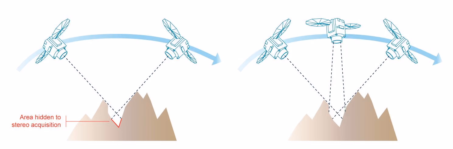
In those cases, you can turn to stereo or tri-stereo images and generate your own elevation models. This method provides more accuracy and allows us to determine the level of a threat posed by an object. You can also compare DSM made from tasked stereo data to your base reference.
Stereo imagery, satellite tasking, and utility vegetation management
DEM generation and terrain reconstruction from stereo imagery can be a more efficient method than traditional airborne LiDAR, as satellite imagery can cover a larger area. As explained in this blog, stereo imagery refers to the capture of two or more images of the same area from different positions so that the same scene is visible in different photographs. When you overlay two images, you create a stereo pair. When you overlay three images, you get a tri-stereo image. Stereo images enable the generation of 3-dimensional models and naturally, tri-stereo images create more accurate 3-dimensional models as compared to basic stereo. Satellites can capture image pairs either in one pass, along the same orbit (along-track stereo), or from different orbits (across-track stereo). You can use stereo imagery to extract stereo DEMs and DSMs. Stereo imagery can also be complemented with LiDAR, SAR, and survey data to extract insights from different datasets and get a fuller picture in more densely vegetated areas.
You can access stereo and tri-stereo imagery from UP42’s platform. You have the option to use historical archive data to detect changes and make predictions. Simply search existing imagery for your AOI in our catalog. Or task a satellite to get fresh imagery. Some of the main benefits include:
- Capture thousands of kilometers of linear infrastructure in a single pass for larger-scale vegetation management
- Identify risk areas to avoid more costly image-capture methods for the entire infrastructure and to drive cost savings over wide areas
- Identify the health and species of vegetation remotely
- Maximize compliance and minimize employee risk by imaging the most inaccessible parts of your infrastructure
- Improve overall scalability, reliability, and flexibility by tasking a satellite for the whole duration of your project
Some of the typical challenges you might face with this approach are the cost of tasking a satellite, as well as the higher level of technical expertise needed for DEM generation. With UP42, you can task satellites from different providers depending on your budget and the nature of your project.
How can I task a satellite to get stereo imagery?
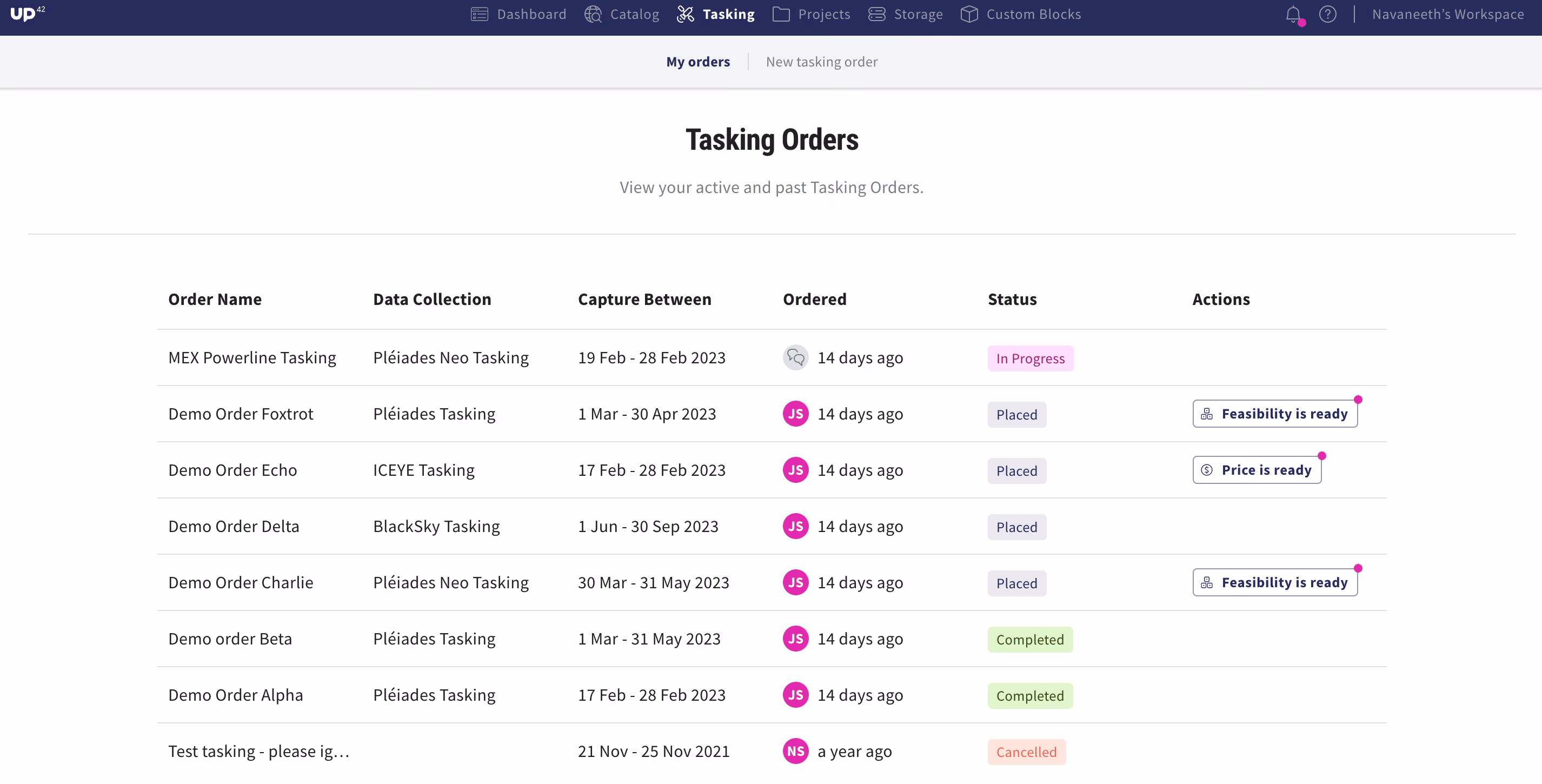
With UP42 tasking, you benefit from fully automated cross-sensor tasking. Search for the specific collection you want, review feasibility options, and place orders—all from within the console. And the best part: UP42 helps you reduce risk and increase total capture by tasking more than one provider for your project. We have several providers integrated into our tasking platform that offer stereo/ tri-stereo capabilities.
Optical
Pléiades Neo provides very high resolution 30 cm images acquired bi-daily on a global basis. In addition to mono, Pléiades Neo has stereo and tri-stereo capabilities.
Pléiades provides high resolution 50 cm images acquired daily on a global basis. Acquisition types offered include mono, single-pass stereo, and tri-stereo.
With SPOT 6/7 you get high resolution 1.5 m images acquired daily on a global basis, as well as stereo and tri-stereo capabilities.
HeadAerospace’s Superview four identical satellites have a native resolution of 0.5 m. This satellite also provides stereo imaging, a deep archive, and significant imaging capacity.
HeadAerospace’s TriStereoZY3 is a 3-satellite constellation offering tri-stereo imaging in a single pass and 2.1 m resolution.
GaoFen-7 from HeadAerospace offers a stereo satellite with two onboard cameras offering 0.65 m resolution.
BlackSky’s constellation of Earth observation satellites offers high-revisit, high resolution (0.83 m to 1.3 m) low-cost imagery for site monitoring with stereo acquisition mode.
SAR
You can also leverage SAR to create DEM using interferometry, or InSAR. Combining two or more SAR images originating from a different position over the same region helps reveal surface topography. And since SAR can penetrate clouds and other obstacles, it can be a useful method for areas where traditional methods are lacking. You can task ICEYE and Capella Space satellites directly from our tasking interface.
Capella Space constellation of X-band SAR satellites delivers high-revisit and high-resolution data (0.5 m - 1.2 m). Great for change detection and verification.
ICEYE’s radar satellite imaging service is designed to deliver very frequent coverage, ideal for persistent monitoring. Capable of up to a ground resolution of 1 m.
You can find more guidance on ordering stereo imagery on the UP42 platform in this article.
Accessing and visualizing your data
In addition to all the exciting new partners that have joined our platform, we’ve also worked hard to make it easier for you to access and visualize imagery that you purchase on UP42. The UP42 ArcGIS Pro Add-in allows you to instantly connect your ArcGIS Pro account with UP42's platform. Search for, order, and analyze imagery directly from your ArcGIS Pro account. You can read more here.
Supporting you from start to finish
And if you still have questions or are unsure of the best approach for your project, our teams will help you to define requirements, recommend the best data, and monitor your ongoing technical and data acquisition progress from start to finish. UP42 has the infrastructure to process urgent requests so you can obtain your data as soon as possible and stay on budget.


Subscribe to our newsletter
Stay up to date and learn about our fast-growing new features
