What does “high resolution satellite imagery” mean, anyway?
Editor's note: this article was originally published on September 25th, 2023. It was revised and updated on October 31st, 2025.
60 m, 30 m, 10 m, 30 cm, 15 cm. Since the launch of the first Earth observation satellite in 1972, the spatial resolution of satellite imagery has kept increasing, and so have the applications. Imagery is used to monitor land cover changes, detect deforestation, map urban change, estimate carbon stocks, and inform disaster response.
Amongst other factors, the imagery used for an application depends on how well an object can be seen in the image, i.e., spatial resolution. Based on this, satellite images are described as low resolution, medium resolution, or high/very high resolution.
But what does that actually mean? This article will explain, and highlight the value of higher resolutions. Let’s get started.
Types of satellite imagery
Satellite imagery may be optical, thermal, or microwave images, depending on the portion of the electromagnetic spectrum captured by the sensor.
Optical satellite images are captured in the visible and infrared portions of the electromagnetic spectrum, thermal images are sensed in the infrared portion, and synthetic aperture radar (SAR) images are captured in the microwave portion.
The different types of satellite images are complementary, with one type making up for the weaknesses of the other, and vice versa. For example, optical satellite imagery suffers occlusion from clouds. SAR images, however, are unaffected by clouds and can thus be integrated with optical imagery to fill gaps in persistently cloudy areas.
Types of satellite imagery resolutions
Resolution is a measure of what can be identified in an image. There are several measures of resolution, including:
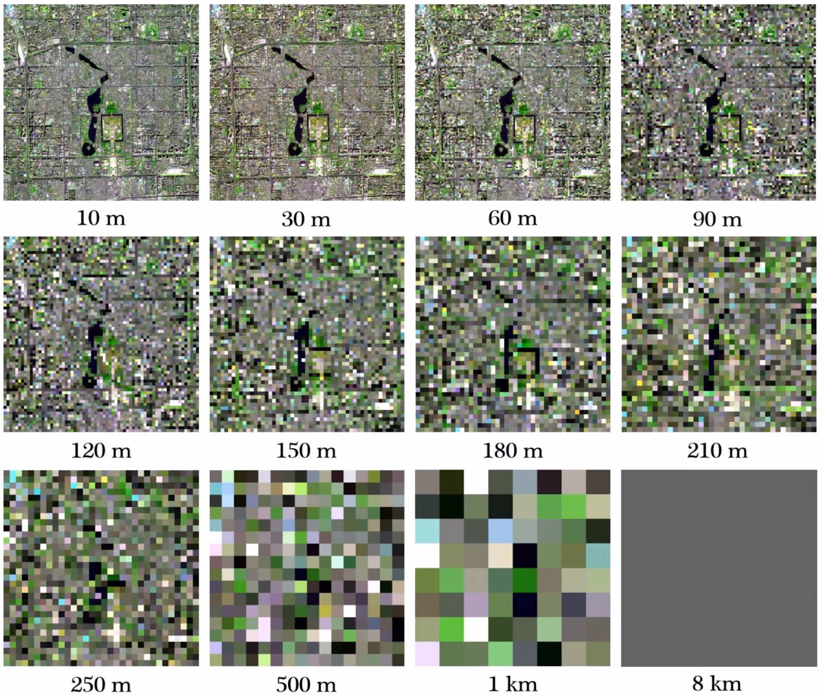
- Spatial resolution: The smallest size of an object on the Earth's surface that can be seen as being separate from its surroundings in the image. The spatial resolution may be taken to equal the area on the ground represented by a single pixel on the image, but this is not always the case. Nevertheless, spatial resolution is usually reported as ground sampling distance (GSD). The spatial resolution affects the detail to which we can identify features in the imagery. Based on the spatial resolution, satellite imagery may be classified as course/ low resolution, medium resolution, and fine/ high resolution.
Note: The spatial resolution of SAR imagery is usually stated in two directions: ground range (distance along the ground) and azimuth direction (the dimension along the flight path).
- Temporal resolution: The frequency with which a location on the Earth's surface is imaged. It is also known as revisit time and is usually expressed as the number of days. A satellite that images the same area within a shorter time than another sensor is said to have a higher temporal resolution Temporal resolution determines the applicability of satellite imagery in change detection. For example, high temporal resolution imagery is important for capturing time-sensitive variability like damage caused by ongoing flooding.
- Spectral resolution: The number of bands or wavelength intervals captured by an optical sensor. It determines the ability to distinguish between features based on their spectral properties. Based on the spectral resolution, optical satellite imagery may be classified as panchromatic, multispectral, or hyperspectral.
Note: SARs are active sensors that transmit microwave signals at a specific wavelength and measure the backscattered portion of the signal. Therefore, unlike optical images, SAR images do not capture the spectral reflectance of features.
Depending on the application, the spatial, spectral, and temporal resolution are key factors to consider when choosing satellite imagery. In this article, we are interested in spatial resolution. Let's go into more detail.
Breaking down spatial resolution
Optical satellite imagery may be classified as
- Low resolution: >20 m
- Medium/ coarse resolution: > 2 m to ≤ 20 m
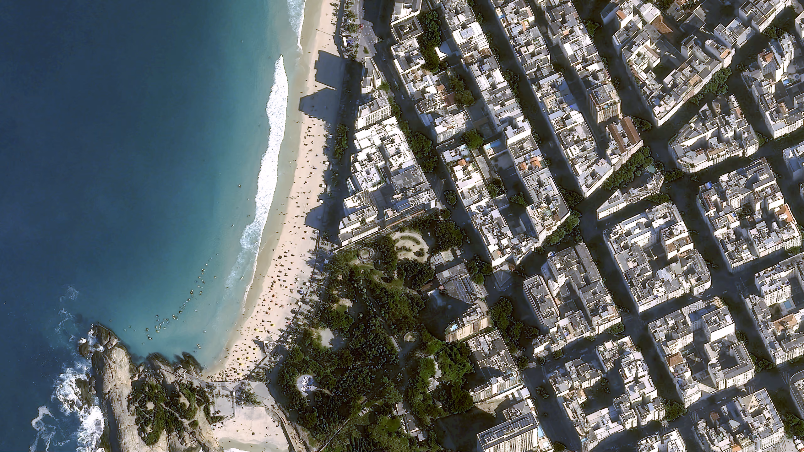
- High resolution: > 50 cm to ≤ 2 m
- Very high resolution: ≤ 50 cm
SAR imagery, on the other hand, is usually subdivided based on the wavelength at which data is gathered.
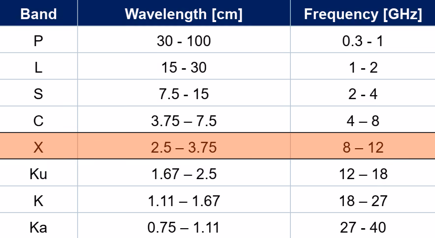
Smaller wavelengths enable the detection of smaller details as compared to longer wavelengths. Therefore, SAR imagery gathered at smaller wavelengths is high resolution SAR. With this in mind, X-band SARs are classified as high resolution, C-band as moderate- to high resolution, S- and L-bands as medium resolution, and P-band as low resolution SAR.
Note: With Earth observation technologies constantly evolving, imagery categorized as high, medium, and low resolution keeps changing.
Next, we highlight the technical factors influencing satellite image spatial resolution.
Which factors affect satellite imagery spatial resolution?
The spatial resolution is affected by different factors including:
Satellite altitude: The distance between the Earth's surface and the satellite. Generally, the higher the altitude, the larger the area of coverage but the lower the spatial resolution. As such, high spatial resolution satellites use orbits relatively close to the Earth's surface (Low Earth Orbits, LEO). At the same time, the altitude will determine the time taken by the satellite to complete a full orbit (orbit period).
Temporal resolution: The time taken by a satellite to return to a point over the Earth's surface is determined by the orbit period and sensor swath width. Given the same orbit period, a sensor with a narrower swath width (high spatial resolution) would take longer to image the same point on the Earth's surface compared to a sensor with a wider swath width (low spatial resolution). In short, there is a spatial and temporal resolution tradeoff with high temporal resolution sensors tending to have low spatial resolutions, and vice versa.
Note: To counter the spatial and temporal resolution tradeoff, some satellites can point in different directions---other than only directly downwards---enabling them to reduce the time between successive measurements of the same area. Some work in constellations to minimize the trade-off.
Enhancing the spatial resolution of optical satellite imagery
Let us look at two ways of enhancing the visual representation of lower resolution satellite imagery.
Pansharpening: Some satellites, like Landsat 8, simultaneously capture multispectral and panchromatic image bands. The panchromatic band usually has a higher spatial resolution than multispectral bands. Pansharpening is the process of fusing the two to obtain higher spatial resolution multispectral images. For example, pansharpening Landsat 8 30 m multispectral imagery using the 15 m panchromatic band results in 15 m multispectral images. To find out more, check out our article on pansharpening satellite imagery.
Let us now consider the case where the satellite does not capture a panchromatic band. Or, we want to "sharpen" the imagery beyond the resolution of the panchromatic band. In this case, we turn to the second method.
Upsampling: This entails using machine learning algorithms to enhance resolution. An example is Nara Space's upsampling algorithm that improves the spatial resolution of Pléiades Neo and several other types of imagery.
What does 'high resolution satellite imagery' mean for different applications?
In this section, we highlight the additional value provided by high resolution optical and SAR satellite imagery for different applications.
The value of high resolution optical satellite imagery
Land use land cover mapping: While low resolution imagery is helpful for global or large-area land use land cover (LULC) mapping, it may be inaccurate at local scales, especially in heterogeneous regions like urban areas. High resolution imagery, on the other hand, captures LULC dynamics over smaller areas enabling more representative local scale maps. For example, high resolution imagery enables the mapping of more detailed LULC categories like residential areas, parks, industrial areas, etc. in urban areas.
Further, high resolution satellite imagery enables finer-scale LULC change detection as compared to coarse and medium resolution images.
Vegetation monitoring: High resolution imagery enables finer-scale vegetation monitoring ranging from forest stands to individual trees. Such detailed information is beneficial for several applications. In deforestation monitoring, high resolution imagery can help detect small canopy gaps caused by illegal logging which may be missed by course resolution imagery.
Vegetation monitoring along linear infrastructure like roads, railways, and power lines also benefits from high resolution imagery. High resolution imagery provides information on vegetation type and proximity to infrastructure informing maintenance strategies.
Our case study with our partner Overstory talks about this in more detail.
Precision agriculture: Fragmented fields characterized by crop heterogeneity are challenging to map and monitor using coarse resolution satellite images. High resolution satellite images help to address this problem. They can capture intra-field variability in crop type, crop growth, crop conditions, and soil conditions. This information is essential for informing variable rate fertilization, pesticide application, and irrigation in precision agriculture.
Want a more detailed use case? The German development bank KfW used very high resolution to increase food security in Africa.
The value of high resolution SAR imagery
SAR is a powerful tool for mapping the Earth's topography, monitoring deformation, and studying vegetation, to name a few. But what value does high resolution SAR provide for applications? Let's find out. First, some background.
The wavelength affects the interaction of the radar signal with surface objects. Briefly,
- If the wavelength is approximately the same size as surface height variations (roughness), the backscatter will be stronger, and the surface will appear brighter in the image. Conversely, if the wavelength is larger than surface height variations, there will be little or no backscatter and the surface will appear smooth. This means that higher resolution SAR images, like X-band images, are more sensitive to changes in surface roughness than lower resolution SAR e.g., L-band imagery.
- The longer the wavelength, the greater the penetration depth of the signal through vegetation canopy, ice and dry soil. For vegetation, short wavelengths, e.g., X-band, interact with the top of the canopy with backscattering coming from leaves, twigs, or branches. Medium wavelengths, e.g., C-band, go deeper and interact with the canopy and trunk. Longer wavelengths, e.g., L-band, penetrate the canopy and interact with the ground. Other factors affecting penetration depth include canopy closure, incidence angle, and polarization.
High resolution SAR images provide different advantages. They enable discriminating between smaller objects facilitating visual interpretation, detailed analyses and mapping. For example, individual buildings can be distinguished using high resolution imagery for building-level analyses. This ability to differentiate between smaller objects also allows for high resolution land cover mapping.
SAR imagery not only provides information derived from one image but also reveals additional insights when several images are combined. For example, applying SAR interferometric (InSAR) techniques which combine two or more images of the same area gathered from different antenna positions helps to extract 3-dimensional information about the Earth's surface.
The extracted 3-dimensional information is employed in generating global digital elevation models (DEM). Here, the value of high resolution SAR is the identification of small relief changes enabling the generation of high resolution elevation data. An example is the global 5 m resolution WorldDEM Neo based on TerraSAR-X and TanDEM-X satellites.
SAR interferometry is also useful for change detection. For example, SAR images can be used to monitor displacement due to landslides, land subsidence, or infrastructure failure. The ability of high resolution SAR imagery to discriminate between smaller features makes it possible to monitor the deformation of major urban features like buildings, roads, and bridges, which may not be possible with low resolution SAR. High resolution SAR, therefore, is key for urban monitoring.
In this section, we have highlighted the value high resolution imagery brings to a few applications, but there are many more. Generally, the main value is that it enables investigations at a greater level of detail.
Examples of high resolution satellite imagery
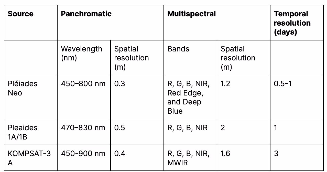
The table below summarizes a few examples of high resolution optical imagery. Some sources provide high resolution multispectral images while others offer high resolution panchromatic images–providing the opportunity to pansharpen.
To satisfy diverse applications, most SAR satellite antennas can be operated in different imaging modes which differ in spatial coverage and spatial resolution. For example, TerraSAR-X has six different imaging modes and can achieve spatial resolutions of between 0.25 m and 40 m. Generally, the higher the spatial resolution, the lower the spatial coverage, and vice versa.
Airbus also now offers an upsampled version of Pléiades Neo, called HD15, which improves imagery resolution even further to 15 cm. You can find more details in our documenation.
Challenges in using high resolution satellite imagery
There are several challenges associated with capturing and processing high resolution images.
First, high spatial resolution satellite imagery is usually more expensive than lower resolution images. Second, high resolution images cover smaller areas meaning that for large-area analyses, several images have to be mosaicked. The resulting large data volumes are challenging to store and process. High resolution images are thus more useful for small-area detailed analyses.
Finally, high spatial resolution imagery contains a high degree of spectral variability within features of the same class. This is because they capture finer details of features. For example, the leaves, branches, and trunk of the same tree may have different spectral characteristics in high resolution images. This within-class spectral variability may lead to poorer classification results.
When should you use high resolution satellite imagery?
While it is tempting to always choose imagery with the highest spatial resolution, the choice of satellite imagery depends on the features or processes to be examined and the available budget and resources.
High spatial resolution imagery is valuable for applications that require a high level of detail as they enable finer-scale analysis and feature extraction than medium or coarse resolution images.
Now that you know what high resolution satellite imagery is and why it is valuable, put it to good use in your applications. Explore our wide range of high resolution imagery.
Key takeaways
- High resolution satellite imagery is usually defined as 1 meter or better. Very high resolution imagery is even finer, at 50 cm or better.
- Spatial resolution is measured in Ground Sample Distance (GSD), which is the distance between the centers of two side-by-side pixels on the ground. Bigger is not better: a smaller GSD number means a higher resolution.
- Using upsampling algorithms like this one can further improve the resolution of already very high resolution images.
- The true value of very high resolution imagery is its ability to see and analyze small features in clear detail, from larger items like buildings to smaller features like trees, cars, and infrastucture objects like power line towers.
- While high resolution imagery is essential for many use cases, it's not cheap. Lower resolution imagery is less expensive, high resolution is expensive, and very high resolution is the most expensive. It's important to find the balance between price and resolution for your use case.


Subscribe to our newsletter
Stay up to date and learn about our fast-growing new features
