An introduction to orthorectification

Editor's note: this article was originally published on February 9th, 2023. It was revised and updated on December 3rd, 2025.
They have the aesthetic quality of a photo and the planimetric geometry of a map. You can use them to measure true ground distances, angles, and positions. Unlike maps, which represent features as points, lines, or polygons, they represent features as images.
They are orthorectified images—also known as orthoimagery or orthophotos. And they’re produced through a process known as orthorectification.
In this article, we dig into orthorectification: what it is, why it is important, how it is performed, and where it is applied.
Want to perform orthorectification yourself? Check out our practical guide.
What is orthorectification?
Orthorectification is the process of removing image distortions or displacements caused by sensor tilt and topographic relief.
Orthorectification aims to ensure that every point on the image is represented as if it were captured directly below the sensor (i.e., at nadir). Orthorectification places image features in their true ground position while ensuring a uniform scale.
What causes the distortions?
Broadly, image distortions may be categorized as arising from:
- The "observer" or acquisition system, e.g., sensor tilt, the motion of the platform, and the motion of the scanning system.
- The "observed" or factors external to the acquisition system, e.g., the Earth's rotation, curvature, topography, and atmosphere.
The effects of sensor tilt could be reduced if images are collected as close to nadir as possible. In practice, however, and especially for satellite platforms, sensor rotation is important for enabling flexibility and revisit capabilities.
With satellite platforms operating from relatively stable orbits and at a higher altitude as compared to airborne platforms, the effects of distortion are generally less pronounced in satellite images than aerial images. But in each case, we must remove or reduce image distortions before attempting to make measurements or extract further information.
Nevertheless, orthorectification in areas with complex high relief features, like buildings, presents some challenges.
What are the challenges of orthorectification in complex high relief areas?
The use of digital terrain models (DTMs) for orthorectification means that only the base of vertical features like trees and buildings are rectified to their correct position. Away from the ground level, there is a shift and such features appear to lean. This occurs because DTMs do not capture the height of aboveground surface features like trees, buildings, bridges, etc.
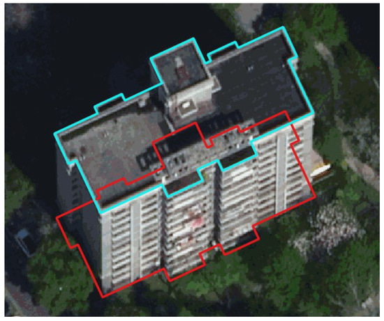
In addition, steep surfaces, like slopes or building walls, lead to occlusion and shadows in the raw images. Consequently, the resulting orthoimage may also contain gaps. These effects are more pronounced in areas with high-rise buildings, reducing their application in urban mapping.
To eliminate these errors, true orthorectification is usually applied.
What is true orthorectification?
True orthorectification (or true ortho for short) refers to the process of rectifying surface features like tall buildings and structures–not included in the DTM–to their correct and upright positions. Furthermore, true ortho compensates for gaps resulting from occlusions by high relief features like buildings and other urban structures.
The resulting images are called true orthophotos with aboveground objects depicted as if viewed directly from above. The production of true orthophotos differs from conventional orthophotos with the requirement for modeling aboveground features (captured in DSMs, digital surface models) and visibility analysis.
There are several methods of achieving true ortho. Generally, they entail applying heights from a digital surface model (DSM) rather than a DTM.
What are the benefits of orthorectification?
The main benefit of orthorectification is that it combines the advantages of imagery and maps in one product: orthoimages.
On the one hand, orthoimages are pictorial representations, making them easy to interpret and enabling the identification of ground objects. On the other hand, just like maps, orthophotos are geometrically correct, enabling precise measurement of ground distances on the image.
Specific benefits of orthorectification include:
- A constant scale throughout the image, enabling you to measure ground angles and distances, eliminating the need for field measurement.
- Freedom from geometric distortions caused by relief e.g., leaning structures, and crooked roads, means you can use them to digitize two-dimensional vector features or update maps.
- Registration to a ground coordinate system means you can integrate/ fuse orthoimages with other raster or vector datasets for increased insights.
In Geographic Information Systems (GIS), orthorectification enables accurate data combination and overlay. Orthorectified images also provide:
- Background layers in areas where cartographic data are hard to find
- Up-to-date data which speeds up map production and enables crisis mapping
- Context to analysis results
- New ways of visualization when combined with other digital datasets
The above benefits give rise to the different applications which we look at later.
How is orthorectification performed?
Orthorectification may be performed in two ways. Before we go over those, let us first list the pertinent inputs for orthorectification:
- Rational polynomial coefficients (RPCs). This is a model of the positional relationship between the image and the ground. Raw satellite images are usually distributed with RPCs.
- A digital elevation model (DEM).
In addition to the RPC file and the DEM, if available, ground control points (GCPs) may also be used to increase the accuracy of the resulting orthophoto.
The first way you can perform orthorectification is by using software that supports RPC models. This method is commonly known as the black box or analytical model. Such software can orthorectify images solely based on the RPC files. For high accuracy, you can orthorectify with RPCs and a DEM. Higher accuracies are achievable by orthorectifying using RPCs, a DEM and GCPs.
Note: For imagery within UP42 storage, you can install the UP42 ArcGIS Pro Add-in to take advantage of ArcGIS Pro orthorectification capabilities.
The second way you can perform orthorectification is by using the physical sensor model. Aside from RPC files, this method also requires sensor data (e.g., satellite position and atmospheric conditions) generated during data collection to orthorectify images. A drawback of this method is that it necessitates access to sensor parameters, which are proprietary information that can only be obtained from the image/ sensor owner.
Note: Orthoimage accuracy is dependent on the accuracy of the orientation data (RCP files) and the Digital Elevation Model (DEM) used.
Orthoimagery: Example use cases
Orthoimagery is essential for applications that require accurate positional information and precise measurement of features.
It is commonly used as a layer in GIS environments for:
- Topographic mapping and updating: Through digitizing orthoimage features like roads, buildings, rivers, lakes, forests, etc.
- Land surveying: orthoimagery can be used as rough base maps for relocating property boundaries, field planning and reconnaissance.
- Highway planning and design: Corridor studies, route analysis, preliminary planning, and impact assessment can all benefit from orthophotos.
- Urban planning: Land use mapping on orthoimages to assess changes over time
- Coastal monitoring: Monitoring changes in the coastline, e.g., due to sea level rise or natural events like storms.
- Forest monitoring: Mapping forest size and health, and monitoring trends using multitemporal orthoimagery.
Since satellite orthoimages offer the benefit of large area coverage at consistent time intervals, they find application in environmental monitoring, natural hazard assessment, resource management, change detection, planning, etc.
Orthoimages can also be draped over digital elevation models for 3-dimensional modeling and visualization of the landscape.
The examples presented here are only a small sample of the many ways you could apply orthophotos. We expect new applications to continue emerging in the future.
Examples of orthorectified data you can find on UP42
The UP42 marketplace contains a range of orthorectified products which we highlight below.
At the same time, we recognize that you may opt to perform your image orthorectification. Some imagery products, therefore, are available in three geometric processing levels: primary, projected, and ortho. We also touch on those in this section.
What do we mean when we say primary, projected and ortho geometric processing levels?
- Primary: The image is not orthorectified, but is free of radiometric distortion. RPC files and model data, like the attitude and ephemeris, are provided to facilitate orthorectification.
Who should get this product? Users with considerable expertise in satellite image processing techniques have their GCPs and/or precise DEMs.
Drawbacks: The image cannot be overlaid with maps in a GIS environment.
- Projected: The image is not orthorectified but is projected into a map projection system at a constant altitude relative to a reference ellipsoid. As such, the image still contains terrain distortions. RPC files are provided with the data to aid orthorectification.
Who should get this product? Users with considerable expertise in satellite image processing techniques have their GCPs and/or precise DEMs.
Key benefits: Allows you to visualize the image in a GIS environment together with other layers.
Drawbacks: The image may not align with other map features/ layers due to relief distortions.
- Ortho: Images are free of distortions, including terrain displacements. The images have also been georeferenced, and, if available, ground control points have been used to increase positional accuracy.
Who should get this product? Those unfamiliar with satellite image processing techniques or when imagery needs to be immediately usable in a GIS environment.
Key benefits: Image can be superimposed on other data in a GIS environment.
The table below shows some of the imagery available on the UP42 platform and their corresponding geometric processing level.
Note: Depending on the sensor, satellite tasking enables you to specify the geometric processing level you need your delivered data in. Furthermore, in some cases, tasking also allows you to provide the DEMs and GCPs to be used for orthorectification.
Orthorectified or non-orthorectified?
Geometric distortion is an inevitable consequence of the image capture process. Non-orthorectified images are characterized by positional and scale errors. They are also prone to artifacts like leaning objects and crooked linear features.
Orthorectified imagery is free of distortions, making it essential for applications that require accurate positional information and precise measurement. Orthophotos also ensure accurate data fusion, overlay, and feature extraction.
There is no question that orthoimages are versatile and can serve many purposes. Whether you prefer an already orthorectified image or want to perform orthorectification yourself, at UP42, we offer both options.
Key takeaways
- Orthorectification is the process of removing geometric distortions caused by sensor tilt and topographic features. The aim is to create an image that has the aesthetic quality of a photograph, but the planimetric (horizontal) accuracy of a map, known as an orthophoto.
- Standard orthorectification uses Digital Terrain Models (DTMs), which correct ground level but can leave vertical objects (like skyscrapers or trees) appearing to "lean." True orthorectification uses Digital Surface Models (DSMs) to rectify these above-ground features to their correct upright positions.
- Unlike raw imagery, orthorectified images have a constant scale throughout. This allows users to accurately measure true ground distances, angles, and positions, and makes the images suitable for use as layers in GIS software.
- Performing orthorectification typically requires Rational Polynomial Coefficients (RPCs), which model the relationship between the image and the ground, and a Digital Elevation Model (DEM). Adding Ground Control Points (GCPs) can further improve accuracy.


Subscribe to our newsletter
Stay up to date and learn about our fast-growing new features
